Barn Record Andover
RETURN TO ‘FIND BARNS’
- Overview
-
Designations
Historic Significance
Architectural description:
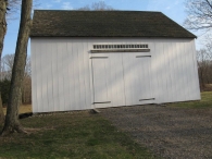
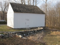
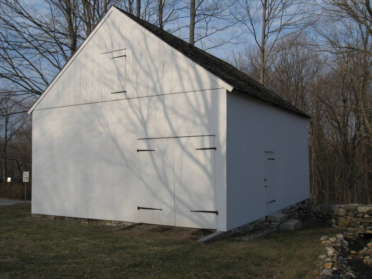
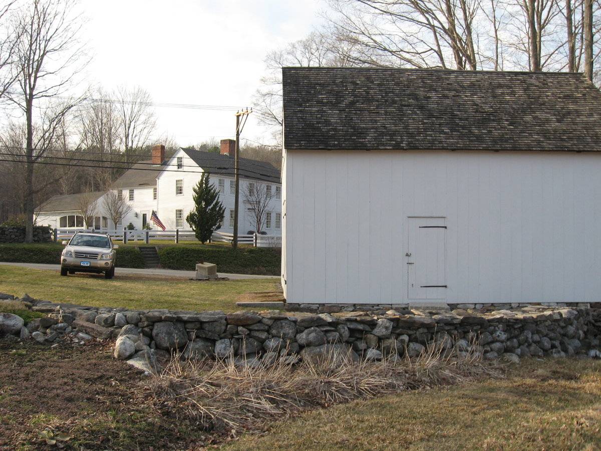
This is a 1 1/2-story three-bay gable-roofed eave-entry barn. The main façade faces northwest and the ridge-line of the barn is approximately parallel with this portion of Hebron Road, which runs southwest-northeast. The main entry is a pair of exterior-swinging doors with iron strap hinges in the middle bay. Above the main entry there is an unpainted wooden lintel and a nineteen-pane transom window. The remainder of the façade is blank. The southwest gable-end has a pair of exterior-swinging doors in the right (south) corner and a single exterior-swinging hay door in the gable attic, above the girt line siding divide. All have iron strap hinges. The ground slopes down gently towards the east, revealing a fieldstone foundation in the southeast eave-side of the barn. This side is blank except for a single exterior-swinging pass-through door to the left (south) of center, which is approached by stone steps. The northeast gable-end appears to be blank, with a fieldstone foundation. The barn has vertical flush-board siding painted white. The roof is covered with wood shingles.
Historical significance:The oldest barns still found in the state are called the “English Barn,” “side-entry barn,” “eave entry,” or a 30 x 40. They are simple buildings with rectangular plan, pitched gable roof, and a door or doors located on one or both of the eave sides of the building based on the grain warehouses of the English colonists’ homeland. The name “30 by 40” originates from its size (in feet), which was large enough for 1 family and could service about 100 acres. The multi-purpose use of the English barn is reflected by the building’s construction in three distinct bays - one for each use. The middle bay was used for threshing, which is separating the seed from the stalk in wheat and oat by beating the stalks with a flail. The flanking bays would be for animals and hay storage.
Historical background:“Statement of Significance:
Today a quiet suburban community, Andover Center Historic District reflects and embodies the historical development of a small rural crossroads village in the Eastern Uplands of Connecticut. During its transition from a separate church society to the institutional center of an independent town, the village became the local market center for a small-scale agrarian-based economy, an evolution reflected in the rural ambience and historic architectural character of the district. The collective significance of the district architecture, which is primarily domestic in nature, is enhanced by fine representative examples of the Colonial, Greek Revival, and Carpenter Gothic styles. The rarity of an associated building type in the district, as well as the exceptional artistic quality of the old burying ground, also add to the overall significance of this cultural landscape.”(Cunningham, Section 8, p.1.)“The oldest surviving building in the district is the Phelps-Bingham House, which sits on a rise above the west side Hebron Road (Inventory #58; Photograph #1). The restored barn across the street remains associated with this property (Inventory #59). One of five eighteenth-century Colonials in the district, the house consists of the original main block, a double cube only one-room deep, and a large rear two-story central chimney ell, with a low rear wing. The principal facade features a later Greek Revival doorway surround, but has retained its multi-light transom and double-leaf paneled doors.” (Cunningham, Section 7, p.2.)
The most evocative emblem of the colonial period is the Phelps-Bingham House, a commanding presence in the district Inventory #58). Exceptionally well-preserved, this classic example of the double-cube form, embellished by a fine Greek Revival doorway, proclaims the land wealth of its early owners. The compatible rear addition and the restored barn across the road (Inventory #59), along with the retention of much of the original acreage, add to the individual significance of this property.(Cunningham, Section 8, p 5.)
Field Notes
Barn was moved with A CAR FROM farther up Route 316 Barn dates 1780 post and beam. A beam is inscripted with date inside barn. Was dismantled in 1998 by owner and rebuilt to period build. The name Phillip Bingham is the name of owner in 1700's. John Bolton is 8th generation; I think he had a lot of information could not spend anymore time listening. He would be fine with any contact from you for info. This address is an approximation. The property is located across the street from 40 Hebron Road. Contributing resource in Andover Center Historic District.
- Use & Accessibility
Use (Historic)
Use (Present)
Exterior Visible from Public Road?
Yes
Demolished
n/a
Location Integrity
Moved
- Environment
Related features
Environment features
Relationship to surroundings
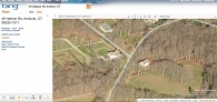
The barn fronts Hebron Road and is on the opposite side of the road from the house with which it is associated. Hebron Road runs generally north-south but curves toward the east at this point. The ridge-line of the barn is parallel to the road and at a diagonal to the ridge-line of the main portion of the house. The 2 ½-story center-chimney Colonial style house, built in c. 1740, has its main entry in the east eave-side of a gable-roofed block oriented with the ridge-line north-south. A 2 1/2-story wing projects west from the main block and a 1-story ell extends west from the southwest corner of the wing. There are extensive gardens and woodlands associated with the house, which occupies a 50-acre lot. The barn occupies its own lot of 5 acres. A short gravel driveway leads southwest from Hebron Road to the main entry of the barn. There is parking area adjacent to the northwest corner of the barn and a grassed open area beside the southwest gable-end. There appears to be a stream running alongside the southeast eave-side of the barn following the gentle slope of the land towards the east. A retaining wall extends from the east half of the southeast eave-side and curves away towards the west. There are woodlands on the northeast side of the barn. The area surrounding the site is open land, woodland and scattered housing. The property is at the southwest edge of the village of Andover, located where Jonathan Trumbull Highway (US Route 6 today) meets Hebron Road.
- Typology & Materials
-
Building Typology
Materials
Structural System
Roof materials
Roof type
Approximate Dimensions
775 square feet
- Source
-
Date Compiled
03/09/2011
Compiled By
L. Mackintosh & T. Levine, reviewed by CT Trust
Sources
Field notes and photographs by Pamela Brown date 6/6/2010.
Town of Andover Assessor’s Record or GIS Viewer: http://data.visionappraisal.com/AndoverCT/
Parcel ID: 33/ 031/ 000002/ / /Aerial Mapping:
http://www.bing.com/maps accessed 3/9/2010.Cunningham, Jan and Herzan, John, Andover Center Historic District, National Register Nomination No. 03000236, National Park Service, 2002.
Sexton, James, PhD, Survey Narrative of the Connecticut Barn, Connecticut Trust for Historic Preservation, Hamden, CT, 2005, http://www.connecticutbarns.org/history.
Visser, Thomas D., Field Guide to New England Barns and Farm Buildings, University Press of New England, 1997.
- PhotosClick on image to view full file
-