Barn Record Prospect
RETURN TO ‘FIND BARNS’- Building Name (Common)
- Prospect Dairy
- Building Name (Historic)
- Prospect Dairy
- Address
- 177 New Haven Road (Rte 69), Prospect
- Typology

- Overview
-
Designations
Historic Significance
Architectural description:
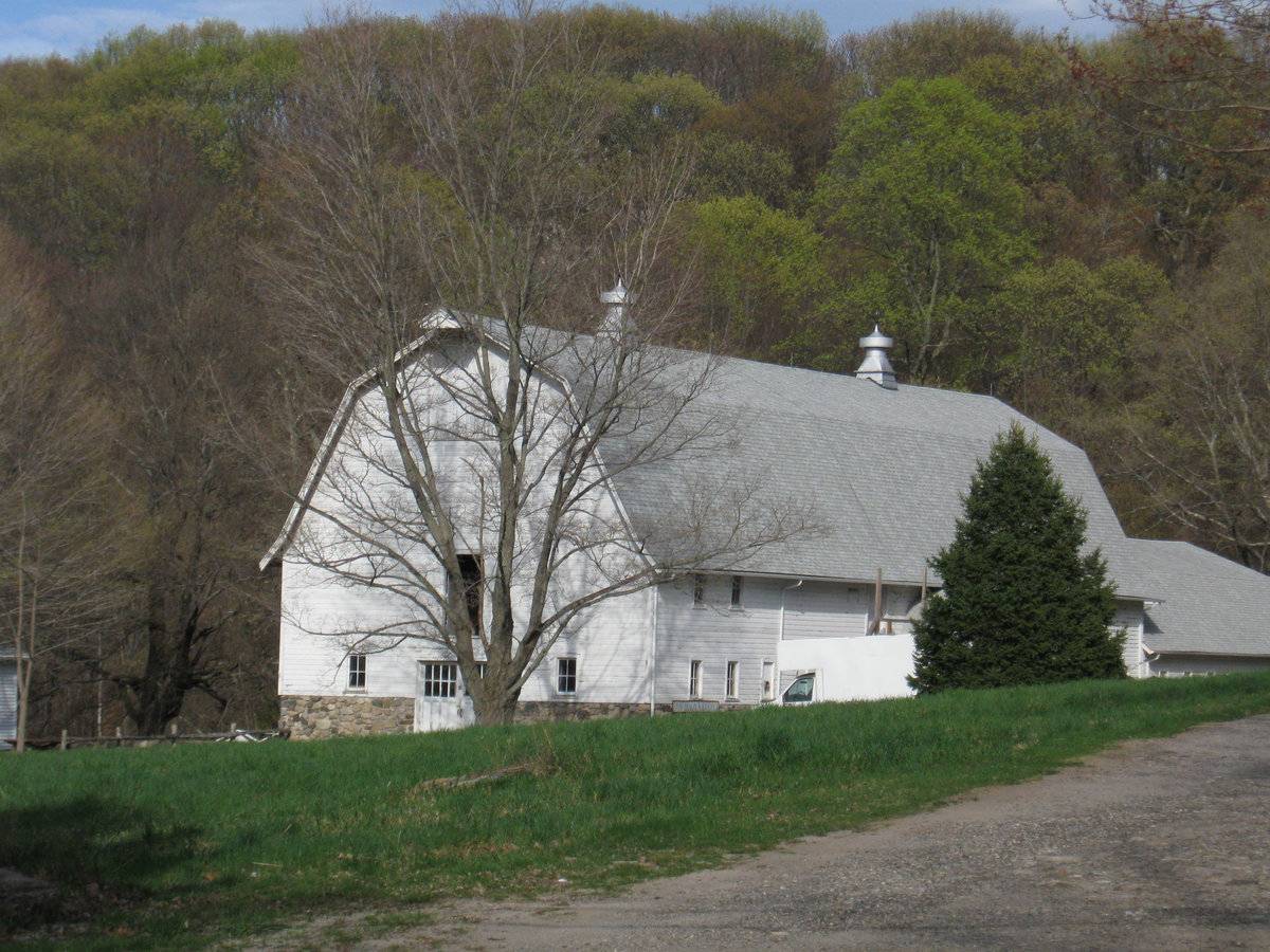
This is a 2 ½ - story multi-bay gable-entry Dutch gambrel-roof bank barn with a 1 ½ - story gambrel-roof addition encompassing the entire length of its east gable-end. The ridge lines of both the main gambrel-roof barn and the gambrel-roof addition run east-west perpendicular to New Haven Road. The west gable-end of the main barn facing the road is the main façade with the main entrance at the center through a pair of paneled hinged doors with eight-pane door leafs. The main entrance is flanked by a four-pane window on either side while a tall hinged hay door is centered at the second floor level. The main west gable-façade also has a large hay door just below the apex of the roof which projects out to form the hay hood. The grade level along the west gable-façade of the main barn gradually declines towards the north along the un-coursed mortared field stone masonry up to sill level of the windows at the first floor, that continues to wrap the barn around its north eave-side. The north eave-side of the barn flush with the north eave-side of the gambrel-roof addition has series of four-pane windows and a continuous margin of un-coursed mortared field-stone masonry along the low grade level. The multi-bay south eave-side of the barn has a small gambrel-roof addition at the center with series of four-pane windows lining the first floor level and the second floor level. The south eave-side of the gambrel-roof addition is flush with the south eave-side of the main barn and also has a similar row of four-pane windows. The Dutch gambrel-roof of the main barn has two steel ventilators along the ridge line; one each towards either side while a steel vent can be seen rising from the gambrel-roof addition, off-centered towards the north.
The wooden frame of the barn is supported on un-coursed mortared field stone masonry foundation. The barn has asphalt shingles roofing and white painted horizontal siding walls.
Historical significance:
By the early 20th century agricultural engineers developed a new approach to dairy barn design: the ground-level stable barn, to reduce the spread of tuberculosis bacteria by improving ventilation, lighting, and reducing the airborne dust of manure. A concrete slab typically serves as the floor for the cow stables. Many farmers converted manure basements in older barns into ground-level stables with concrete floors. Some older barns were jacked up and set on new first stories to allow sufficient headroom. With the stables occupying the entire first story, the space above serves a a hayloft. By the 1920s most ground-level stable barns were being constructed with lightweight balloon frames using two-by-fours or two-by-sixes for most of the timbers. Novelty or tongue-and-groove beveled siding is common on the walls, although asbestos cement shingles also were a popular sheathing. Some barns have concrete for the first-story walls, either poured in place or built up out of blocks.
The gambrel roof design was universally accepted as it enclosed a much greater volume than a gable roof did, and its shape could be formed with trusses.
Also see entry for Pole Barn.Field Notes
Listed on the State Register of Historic Places 5/01/2013 Built in 1935 with addition in 1942. Gambrel roof
- Use & Accessibility
Use (Historic)
Use (Present)
Exterior Visible from Public Road?
Yes
Demolished
n/a
Location Integrity
Original Site
- Environment
Related features
Environment features
Relationship to surroundings
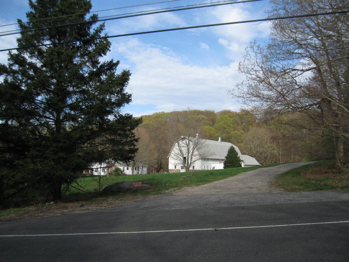
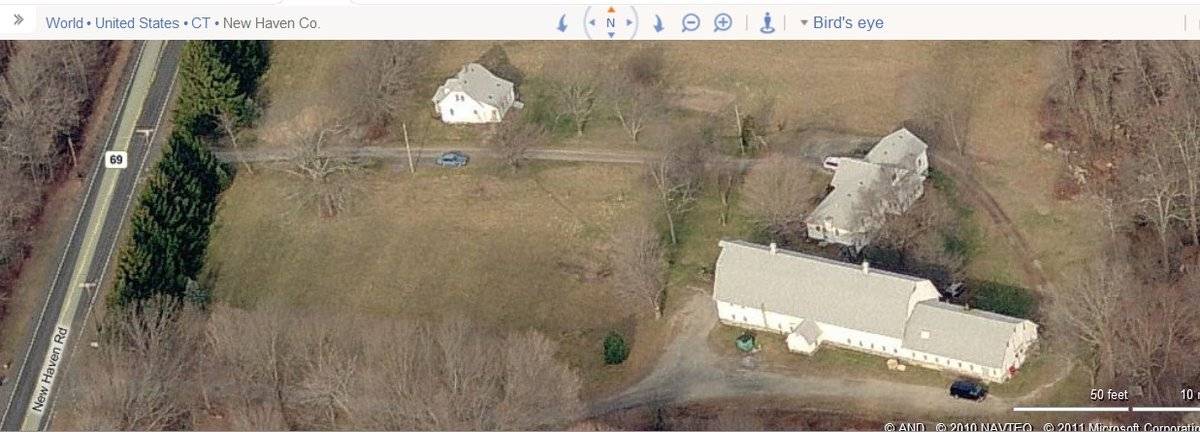
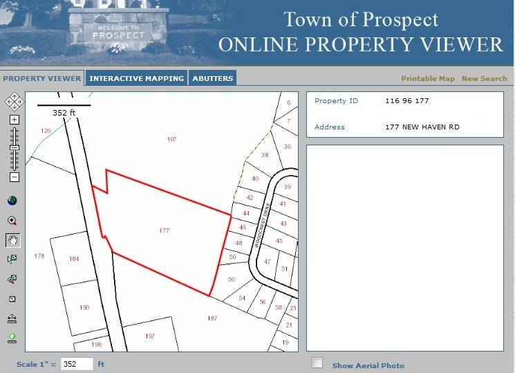
The 10.75 acres property, Account Number- V0301300 and Map number- 116 96 177, is located towards the east of New Haven Road. The property is located in a sparsely populated residential area of rural character with individual plots separated by woodland. Residential plots can be seen towards the south and the southwest of the property across the road while the area towards the north, east and the west is covered by dense woodland.
The barn is located in the southeast corner of the property, offset from New Haven Road. The ridge line of the barn runs east-west almost perpendicular to the road. The circa 1925 ranch style main residence is located towards the immediate north of the barn. A circa 1935 second residence is located towards the northwest of the barn. The property is accessed by a through-driveway towards the south of the circa 1935 residence that continues eastwards encircling the other residence and the barn, and exits along the south eave-side of the barn. The property has open land towards the north and the west of the building complex while dense woodland can be seen along the fringes and beyond.
- Typology & Materials
-
Building Typology
Materials
Structural System
Roof materials
Roof type
Approximate Dimensions
Barn: 3672 SqFt, 1944 SqFt
- Source
-
Date Compiled
06/15/2011
Compiled By
T. Levine and M. Patnaik, reviewed by CT Trust
Sources
Field notes and photographs provided by: Charlotte Hitchcock, 04/17/2010.
Assessors’ records retrieved on June 15th, 2011 from website http://www.prophecyone.us/index_prophecy.php?town=Prospect
GIS Map and information retrieved on June 15th, 2011 from website http://host.appgeo.com/prospectct/Map.aspx
Photograph/Information retrieved on June 15th, 2011 from website http://www.google.com
Photograph/Information retrieved on June 15th, 2011 from website http://www.bing.com.
Photograph/Information retrieved on June 15th, 2011 from website http://www.zillow.com.
Sexton, James, PhD; Survey Narrative of the Connecticut Barn, Connecticut Trust for Historic Preservation, Hamden, CT, 2005, http://www.connecticutbarns.org/history
Visser, Thomas D., Field Guide to New England Barns and Farm Buildings, University Press of New England, 1997.
- PhotosClick on image to view full file
-