Barn Record Suffield
RETURN TO ‘FIND BARNS’- Building Name (Common)
- James Hall House
- Building Name (Historic)
- James Hall House
- Address
- 15 High Street, Suffield
- Typology

- Overview
-
Designations
Historic Significance
Architectural description:
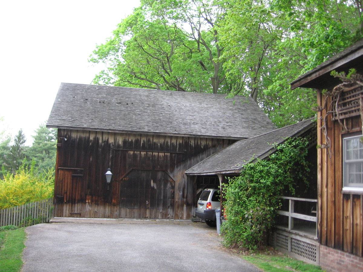
This is a 1 ½ story eave-entry tripartite bank barn with an open shed addition. The main façade of the barn faces east and the ridge-line of the barn is roughly parallel to High Street which runs approximately north-south. The main entry is on the east, eave-façade and consists of a twentieth-century wooden overhead garage door with chamfered corners. A rail is located a couple of feet above the door suggesting that an older door may have been an exterior sliding door. The door is located in the middle bay with a modern electric lantern-style light hanging on the southern side. The southern bay contains a pass-through door with hand-wrought hardware on the southern corner. The northern bay has an eight-light window that is under the open shed addition that projects eastward. The south façade appears to have no door or window openings but as the property slopes downwards from east to west, a basement level is revealed. The west façade has an open basement. Wooden posts support the structure. The open shed’s ridge-line runs east-west and it has two bays on the south façade. The barn is clad in unpainted board and batten siding. The roof is covered with wood shingles. The frame sits on a brick foundation.
Historic significance:“The oldest barns still found in the state are called the ““English Barn,” “side-entry barn,” “eave entry,” or a 30 x 40. They are simple buildings with rectangular plan, pitched gable roof, and a door or doors located on one or both of the eave sides of the building based on the grain warehouses of the English colonists’ homeland. The name ““30 by 40”” originates from its size (in feet), which was large enough for 1 family and could service about 100 acres. The multi-purpose use of the English barn is reflected by the building’s construction in three distinct bays - one for each use. The middle bay was used for threshing, which is separating the seed from the stalk in wheat and oat by beating the stalks with a flail. The flanking bays would be for animals and hay storage.
The 19th century saw the introduction of a basement under the barn to allow for the easy collection and storage of a winter’s worth of manure from the animals sheltered within the building. The bank barn is characterized by the location of its main floor above grade, either through building into a hillside or by raising the building on a foundation. This innovation, aided by the introduction of windows for light and ventilation, would eventually be joined by the introduction of space to shelter more animals under the main floor of the barn.”Field Notes
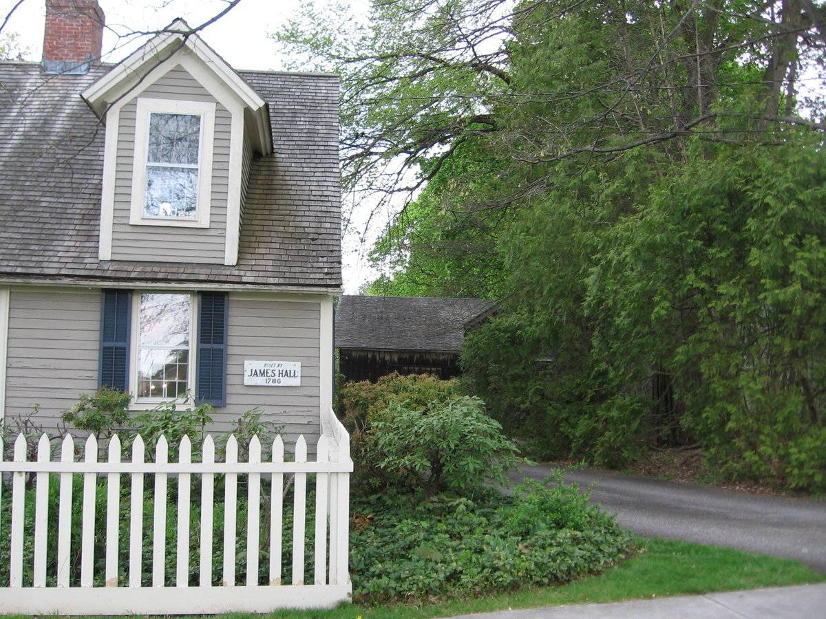
This home and the outbuildings are in the center of town across from the South Green. It has had additions over the years but the main part of the house is dated 1786. The largest barn (at the end of the driveway) is a bank barn with a brick foundation. There is an attached shed structure which forms an "L" with the barn that looks like a typical horse shelter. In addition, there is an additional two story building which looks as if it were built later and its age is uncertain. It has been modernized. The property has clearly been a Suffield fixture for many years.
- Use & Accessibility
Use (Historic)
Use (Present)
Exterior Visible from Public Road?
Yes
Demolished
n/a
Location Integrity
Unknown
- Environment
Related features
n/a
Environment features
Relationship to surroundings
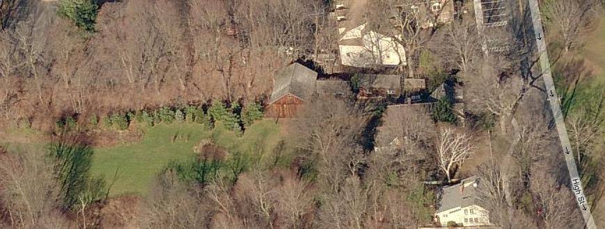
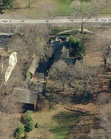
This barn is set on a 1.32-acre property that is located on the west side of High Street approximately half-way between the intersection of High Street and Mountain Road and the intersection of High Street and South Main Street. The property is bounded by High Street to the east; the 7.46-acre Phelps-Hatheway House & Garden, a property owned by CT Landmarks (http://www.ctlandmarks.org/index.php?page=phelps-hatheway-house-garden), consisting of both grassy lawn and woodlands is to the south; an 11-acre wooded lot owned by the Town of Suffield to the southwest; the 3.29-acre lot holding the Town Hall, designed by Keith Sellers Heine and built by the John Romano Construction Company in 1962 (http://www.suffieldtownhall.com/content/77/93/656.aspx), to the west; and three lots containing commercial buildings to the north. A late eighteenth-century house is located to the east of the main barn. The ridge-line of the house is roughly parallel to the High Street and the house is situated very close to the curb. An early twentieth-century cottage is located adjacent to the open shed addition to the east. A tree-covered garden area is between the house and barn. An open, grassy field is directly west of the barn.
- Typology & Materials
-
Building Typology
Materials
Structural System
n/a
Roof materials
Roof type
Approximate Dimensions
1000 sq ft
- Source
-
Date Compiled
08/17/2010
Compiled By
Melissa Antonelli, reviewed by the CT Trust
Sources
Photographs by Janet Banks.
Connecticut Landmarks, http://www.ctlandmarks.org/.
Map of Suffield, CT, retrieved Aug 17, 2010 from website www.bing.com.
Ransom, David, Suffield National Register District Nomination No. 79003750, National Park Service, 1979.
Sexton, James, PhD, Survey Narrative of the Connecticut Barn, Connecticut Trust for Historic Preservation, Hamden, CT, 2005, http://www.connecticutbarns.org/history.
Ransom, David F., Suffield Historic District National Register Nomination No. 79003750, National Park Service, 1979.
Town of Suffield, http://www.suffieldtownhall.com.
Vision Appraisal Online Database. www.visionappraisal.com/SuffieldCT.
Visser, Thomas D., Field Guide to New England Barns and Farm Buildings, University Press of New England, 1997.
Local Historic District - Main Street Historic District, 1963.
- PhotosClick on image to view full file
-