Barn Record Norwich
RETURN TO ‘FIND BARNS’- Building Name (Common)
- n/a
- Building Name (Historic)
- Simon Huntington Home Lot
- Address
- 61 East Town Street, Norwich
- Typology

- Overview
-
Designations
Historic Significance
Architectural description:
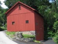
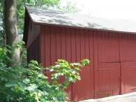
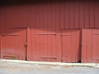
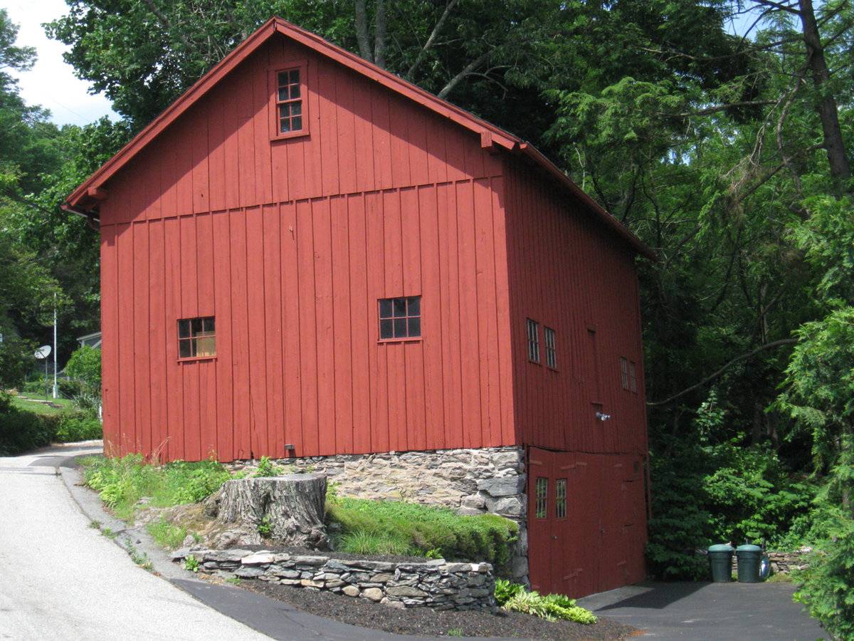
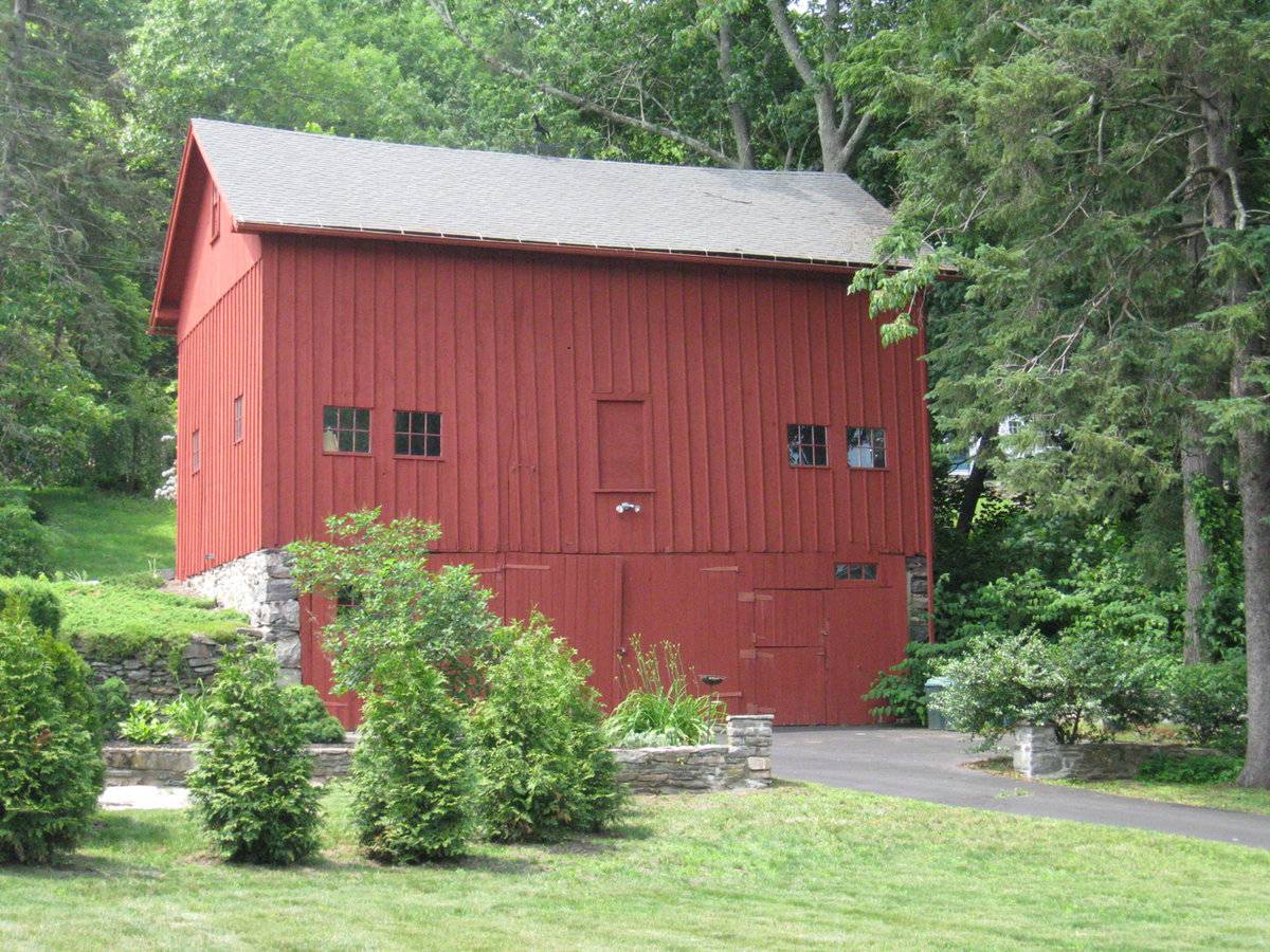
This is a 1 ½-story three-bay gable-roofed bank barn structure with its ridge-line oriented southwest-northeast. The main (upper level) entry is in the northwest-facing eave-side, accessed from Mediterranean Lane. There is a pair of hinged barn doors in the center bay, which appear to have been full height but to have been split into upper and lower leaves, with the upper fixed shut. These have long iron strap hinges on the lower operable leaves. The left and right bays also have pairs of hinged doors. The right (south) doors have iron strap hinges. This side has board and batten siding.
The northeast gable-end faces the side property line and is inaccessible. It appears to have no openings at the main level, where the siding is board and batten. The attic gable has flush-board vertical siding and there is a window near the peak.
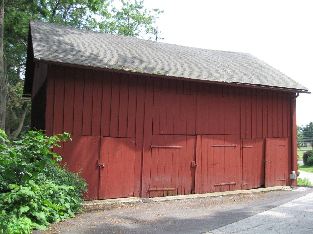
The southeast eave-side opens at the basement level to the parking area and yard level of the property. At the basement level, the mortared fieldstone end walls of the gable-end foundations are exposed. The three bays of the eave-side have pairs of hinged doors. The left pair has iron strap hinges and a four-pane light in each leaf. The center pair is solid planking with iron strap hinges. The righthand bay has a shorter pair in which the left leaf is split like a stable door. There is a horizontal three-pane window above the right leat. Above at the main level, the center bay has a small hay door opening, boarded shut, and there is a pair of six-pane stable windows in each of the flanking bays. Siding is board and batten at the main level.
The southwest gable-end faces the curve of Mediterranean Lane. The grade slopes down from left to right, with the mortared fieldstone foundation wall partially exposed. At the main level there are two six-pane stable windows widely spaced. There is a four-over-four double-hung window in the attic gable near the peak. The main level has board and batten siding and the attic gable has flush-board vertical siding.
The roof has deep overhangs with exposed purlin ends supporting the rakes, where there is a narrow bargeboard trim. Rooding is asphalt shingles. The siding is painted red.
Historical significance:
The oldest barns still found in the state are called the “English Barn,” “side-entry barn,” “eave entry,” or a 30 x 40. They are simple buildings with rectangular plan, pitched gable roof, and a door or doors located on one or both of the eave sides of the building based on the grain warehouses of the English colonists’ homeland. The name “30 by 40” originates from its size (in feet), which was large enough for 1 family and could service about 100 acres. The multi-purpose use of the English barn is reflected by the building’s construction in three distinct bays – one for each use. The middle bay was used for threshing, which is separating the seed from the stalk in wheat and oat by beating the stalks with a flail. The flanking bays would be for animals and hay storage.
The 19th century saw the introduction of a basement under the barn to allow for the easy collection and storage of a winter’s worth of manure from the animals sheltered within the building. The bank barn is characterized by the location of its main floor above grade, either through building into a hillside or by raising the building on a foundation. This innovation, aided by the introduction of windows for light and ventilation, would eventually be joined by the introduction of space to shelter more animals under the main floor of the barn.Until the 1830s, the horses used for riding and driving carriages were often kept in the main barn along with the other farm animals. By the 1850s, some New England farmers built separate horse stables and carriage houses. Early carriage houses were built just to shelter a carriage and perhaps a sleigh, but no horses. The pre-cursor to the twentieth-century garage, these outbuildings are distinguished by their large hinged doors, few windows, and proximity to the dooryard.
The combined horse stable and carriage house continued to be a common farm building through the second half of the nineteenth century and the first decade of the twentieth century, until automobiles became common. Elaborate carriage houses were also associated with gentlemen farms and country estates of the late 19th and early 20th centuries. Another form of carriage barn, the urban livery stable, served the needs of tradespeople.This barn is likely contemporary with its associated house, as the deep overhangs at the roof eaves and rakes are compatible with the Italianate style of the second half of the 19th century. Aside from this detail, the barn resembles the typical English barns of previous decades. As the center of Norwichtown was becoming fully developed by 1860, this may have functioned more as a carriage barn than for agricultural use.
Historical background: The first settlement in Norwich was in 1660 and was located in the area known as Norwichtown. The pattern and features of that settlement are still apparent in the great
number of early structures remaining Some have been altered, reflecting their varied uses. The Historic District includes that area of first settlement, which is the Green and surrounding streets.The “Town Plot” was laid out along the Yantic River. Home lots were several acres and included pasture land. Near the center of the Plot was an open space for public buildings; this area was soon known as the Meetinghouse Plain or the Green. The church had its place here and alternately stood on the Green and on the cliff behind (Meetinghouse Rocks) (Bixby, p. 1).
Field Notes
Located in the Norwichtown National Register Historic District.
- Use & Accessibility
Use (Historic)
Use (Present)
Exterior Visible from Public Road?
Yes
Demolished
n/a
Location Integrity
Unknown
- Environment
Related features
Environment features
Relationship to surroundings
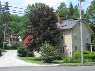
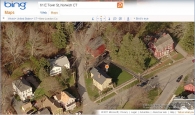
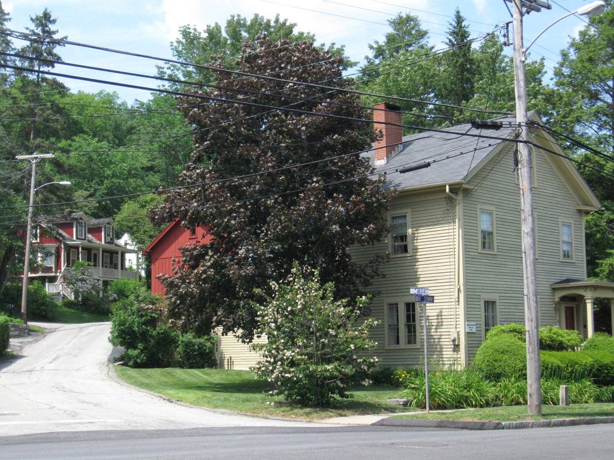
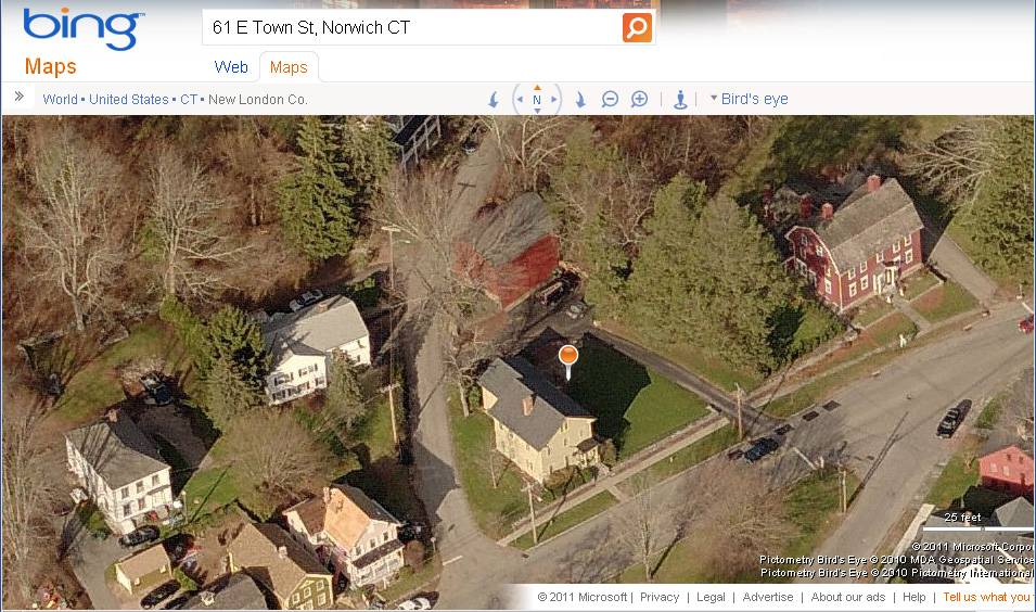
The Norwichtown Historic District, in existence since 1967 as a local district and 1973 as a National Register District, includes the Norwichtown Green and the streets that were laid out around it in the 18th century. This property is located at the north corner of East Town Street and Mediterranean Lane, facing the northwest side of the Green. The house is a 1 ½-story vernacular Italianate style building with its ridge-line oriented perpendicular to East Town Street and its entry in the southeast gable-end facing the street. It has a 1-story one-bay porch at the entry in the right of three bays. There are additions at the rear (northwest) of the house. Mediterranean Lane slopes up and curves from west toward north behind the house, forming a lot with an acute angle corner. The barn is located north of the house close to the rear lane, with upper level access from the lane and basement access at the ground level of the house and East Town Street. A driveway enters the site from Mediterranean Lane and there is a parking area north of the house, between house and barn. The drive also enters the site from East Town Street, running along the east edge of the property toward the barn. The remainder of the site is lawn and some landscaped planting beds. A low fieldstone wall borders the sidewalk line at the southeast frontage of the property.
- Typology & Materials
-
Building Typology
Materials
Structural System
Roof materials
Roof type
Approximate Dimensions
864 square feet
- Source
-
Date Compiled
06/30/2011
Compiled By
Charlotte Hitchcock, reviewed by CT Trust
Sources
Field notes and photographs by Charlotte Hitchcock 6/03/2011.
Norwich Assessor’s Record: http://data.visionappraisal.com/Norwich
Parcel ID: 67/ 2/ 40 House date c. 1860
BRN4 1 STY LFT&BSMT 864 S.F.
Acres: .33Aerial Mapping:
http://maps.google.com
http://www.bing.com/maps accessed 6/03/2011.Bixby, Susan, B., Norwichtown National Register Historic District Nomination No. 73001951, National Park Service, 1973.
Sexton, James, PhD, Survey Narrative of the Connecticut Barn, Connecticut Trust for Historic Preservation, Hamden, CT, 2005, http://www.connecticutbarns.org/history.
Visser, Thomas D., Field Guide to New England Barns and Farm Buildings, University Press of New England, 1997.
Local Historic District - Norwichtown Historic District, 1967:
http://www.historicdistrictsct.org/maps/HistPropList_3.htm - accessed 6/20/2012. - PhotosClick on image to view full file
-