Barn Record Sharon
RETURN TO ‘FIND BARNS’- Building Name (Common)
- Ellsworth Hill Orchard and Berry Farm
- Building Name (Historic)
- Lord-Dunbar Farmstead
- Address
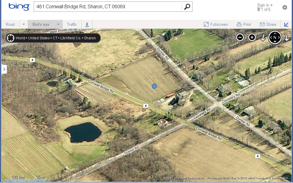
- 461 Cornwall Bridge Road (Rte 4), Sharon
- Typology

- Overview
-
Designations
Historic Significance
Architectural description:
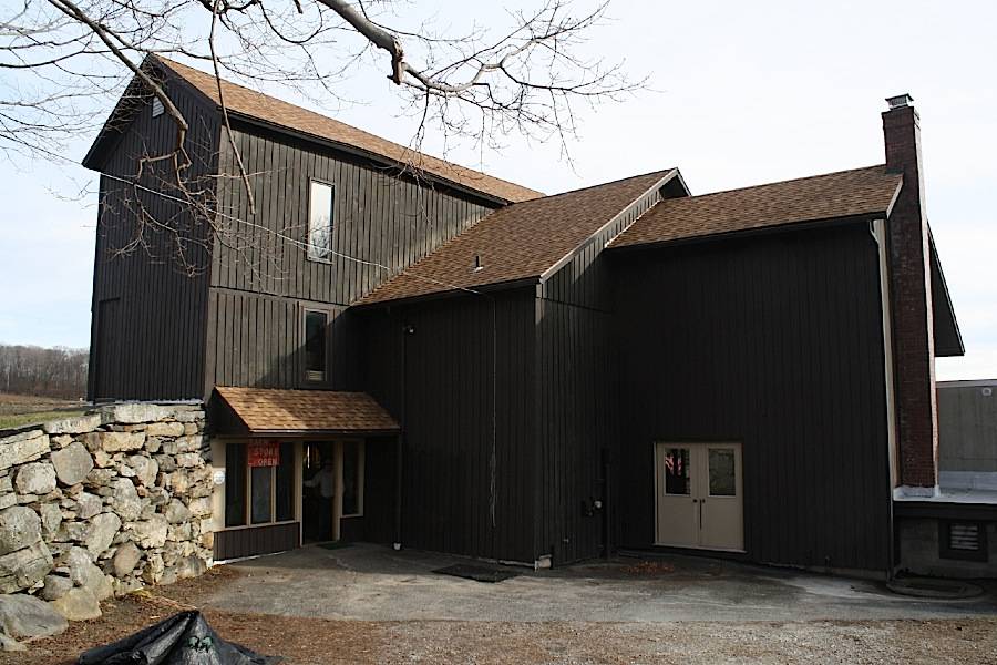
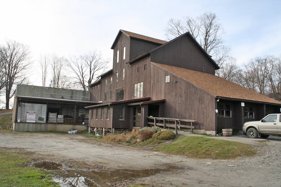
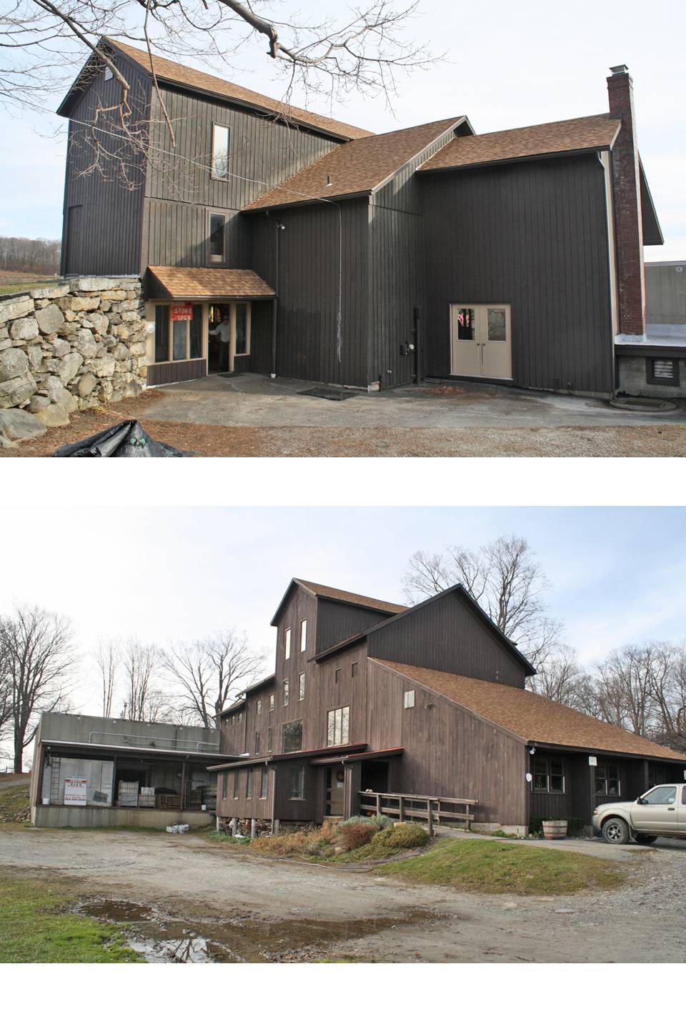
This is a 2 ½-story plus basement hybrid type barn, 30’ x 70’, with entries into various locations on its four levels. The gable roof has its main ridge-line oriented east-west perpendicular to Dunbar and Cornwall Bridge Roads. Siding is vertical boards stained dark brown. Windows are a mixture of casement and picture windows, installed in the early 1980s when the barn was remodeled for use as a store and office space. A large 47’ x 60’ apple storage warehouse with a flat roof is attached at the west gable-end and extends to the south of the barn footprint.
Exterior:
The core frame of the barn was most likely a 30’ x 45’ English barn with three equal bays. Over the years remodeling appears to have altered it into a high-drive bank barn with an unusual cross-gable structure oriented north-south above the center bay. The gable roof of this structure sits higher than the main ridge-line; its north end projects 12’ north of the main barn to form an enclosure for what may have been a high-drive access to the upper hay loft. The current entry into the store is under the high drive, an area that may have been an open passage accessing the center bay of the barn. The south gable-end of the high roof is flush with the south eave-side of the main block, forming the effect of a large wall dormer.
A shed-roofed addition on the east end spans the full width of the east gable-end and its sweeping roof attaches high on the main barn’s east gable-end and then slopes down to a basement level wall to the east. This wing now houses the cider mill in the basement level.
A gable-roofed extension continues the roof line of the main block toward the west. A modern concrete apple storage block is attached at the southwest corner and has a flat roof.
Interior:
The interior is finished and heated space, with gypsum wall board surfaces set back from the face of the post and beam frame to showcase the timber framing. The barn is described by the owners as an 18th-century barn, c. 1760. A few posts and beams appear to be of this vintage while others have been replaced and joints reinforced with steel plates. In the east gable-end wall there is an interior window looking into the cider mill below. The barn as a whole has been altered considerably over its long history. Interior finishes obscure much of the structure.Historical or Architectural importance:
This barn is significant as a major extant structure in the village of Ellsworth, prosperous through the 19th century. The row of historic homes along the west side of Dunbar Road, including the former Dunbar home, along with the massive barn and the agricultural acreage, preserve a historical landscape. The Lord and Dunbar families, as early and long-time farmers and citizens of Ellsworth, were important local citizens. Although the barn has been altered for re-use, the continuation of active agriculture enhances the significance of the building and site.
Historical significance:
The oldest barns still found in the state are called the “English Barn,” “side-entry barn,” “eave entry,” or a 30 x 40. They are simple buildings with rectangular plan, pitched gable roof, and a door or doors located on one or both of the eave sides of the building based on the grain warehouses of the English colonists’ homeland. The name “30 by 40” originates from its size (in feet), which was large enough for 1 family and could service about 100 acres. The multi-purpose use of the English barn is reflected by the building’s construction in three distinct bays - one for each use. The middle bay was used for threshing, which is separating the seed from the stalk in wheat and oat by beating the stalks with a flail. The flanking bays would be for animals and hay storage.
The 19th century saw the introduction of a basement under the barn to allow for the easy collection and storage of a winter’s worth of manure from the animals sheltered within the building. The bank barn is characterized by the location of its main floor above grade, either through building into a hillside or by raising the building on a foundation. This innovation, aided by the introduction of windows for light and ventilation, would eventually be joined by the introduction of space to shelter more animals under the main floor of the barn.High-drive barn: The main innovation of this three- or four-story multi-level design was to provide access near the top of the haymow so that loads could be dumped from wagons rather than hoisted into a loft above. The top main door on High-drives usually extends above the level of the eaves on the sides and often had ramps.
Field Notes
Listed on the State Register of Historic Places 3/05/2014. Historical information compiled by Ellsworth Hill Farm: In the mid-1700s, Jonathan Lord established a farm and built a large barn, which still stands at the site of Ellsworth Hill Farm and Orchard. One of the Lords' descendants married Horace Dunbar, and the property became known as the Dunbar Farm. It was a dairy farm with the barn housing both hay and cattle. The barn is used today as a cider mill. The settlers on Sharon Mountain had built a church at Ellsworth in 1797, and established a school. During the early 1800s the area grew as a self-sufficient community with gristmills, dairy farms, flax mills, sawmills, blacksmith shops, a wagon factory, a wicket-ball bat factory, a post office, and an inn, the Griswold Inn. The local cemetery on Cemetery Road contains stones dating to 1778. www.ellsworthfarm.com
- Use & Accessibility
Use (Historic)
Use (Present)
Exterior Visible from Public Road?
Yes
Demolished
n/a
Location Integrity
Original Site
- Environment
Related features
Environment features
Relationship to surroundings
This barn, formerly the Dunbar Farm barn, has been converted to a farm store. The modern address is on Cornwall Bridge Road (Route 4), which was constructed in the early 1930s, by-passing the village of Ellsworth and running north-south along the east side of the barn. A section of the old Lime Rock-Cornwall Bridge Road, which passes to the west of the barn and was formerly its road access, was re-named Dunbar Road at that time.
In addition to the barn/store, the site includes a small 1-story gable-roofed bungalow residence to the north, facing Cemetery Road, and a hip-roofed structure connected to the bungalow. This appears likely to have been a milk room for the dairy farm, based on its size and shape.
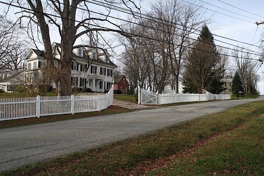
To the northwest, along the west side of Dunbar Road, a row of historic houses and a grange (originally a church) are remnants of the village of Ellsworth. 13 Dunbar Road, a 2 ½-story gable-roofed house whose date is given by the Assessor as 1866, was the Dunbar home, now under separate ownership. The house is a five-bay colonial-style structure with its east eave-side facing the road; the main entry is in the center bay under a columned porch. Three attic dormers project from the roof and a shallow wing projects south from the gable-end. The eaves and gable-ends have deep cornices with molded trim; windows are six-over-six double-hung. Approximately five miles northwest along Route 4 is the Sharon National Register Historic District in the town center on Route 41. Further northwest, the Sharon Valley National Register Historic District recognizes a 19th-century industrial village.
The Barn site sits near the bottom of a long hill sloping down from the western highland area of Sharon Mountain to the Housatonic River at Cornwall Bridge a short distance to the east. Most of the fields and orchards are located to the east of Cornwall Bridge Road, with a small field immediately south of the barn used for an annual corn maze. Customers arrive via a driveway running west from Cornwall Bridge Road to unpaved parking areas at the east and north of the barn/store. Fruits are available in the store or for “pick your own” in season.- Typology & Materials
-
Building Typology
Materials
Structural System
Roof materials
Roof type
Approximate Dimensions
n/a
- Source
-
Date Compiled
10/17/2012
Compiled By
Charlotte Hitchcock, reviewed by CT Trust
Sources
Photographs and field notes by Charlotte Hitchcock 11/15/2012.
Interview with Michael Bozzi, 8/11/2012, at the site.Town of Sharon Assessor’s Records http://data.visionappraisal.com/SharonCT/search.asp
Parcel ID: Map 6x/Lot 37Aerial views from:
http://maps.google.com/ and http://www.bing.com/maps/ accessed 12/11/2012.UTM coordinates: http://itouchmap.com/latlong.html .
Ellsworth Orchard & Berry Farm website: http://www.ellsworthfarm.com/ .
Oglesby, Scott, Connecticut Roads website, http://kurumi.com/roads/ct/index.html .
Sexton, James, PhD; Survey Narrative of the Connecticut Barn, Connecticut Trust for Historic Preservation, Hamden, CT, 2005, http://www.connecticutbarns.org/history.
U.S. Federal Census, accessed at http://persi.heritagequestonline.com/hqoweb/library/do/census/search/basic
Visser, Thomas D., Field Guide to New England Barns & Farm Buildings, University Press of New England, 1997.
- PhotosClick on image to view full file
-