Barn Record Simsbury
RETURN TO ‘FIND BARNS’- Building Name (Common)
- Community Farm of Simsbury
- Building Name (Historic)
- Wolcott Farmstead/Town Farm/Eno Home/Town Farm Dairy
- Address
- 69 Wolcott Road, Simsbury
- Typology

- Overview
-
Designations
Historic Significance
Architectural description:
Barn – gambrel dairy barn wing:
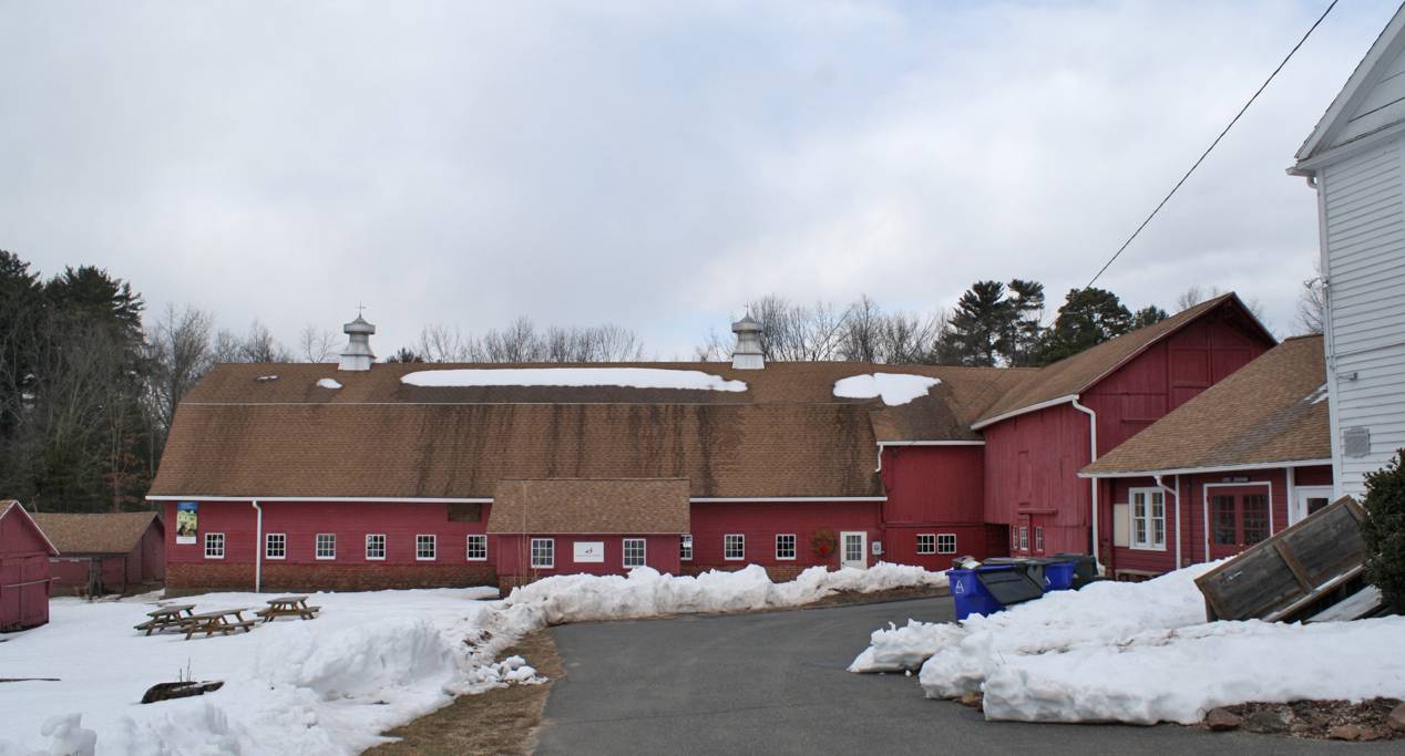
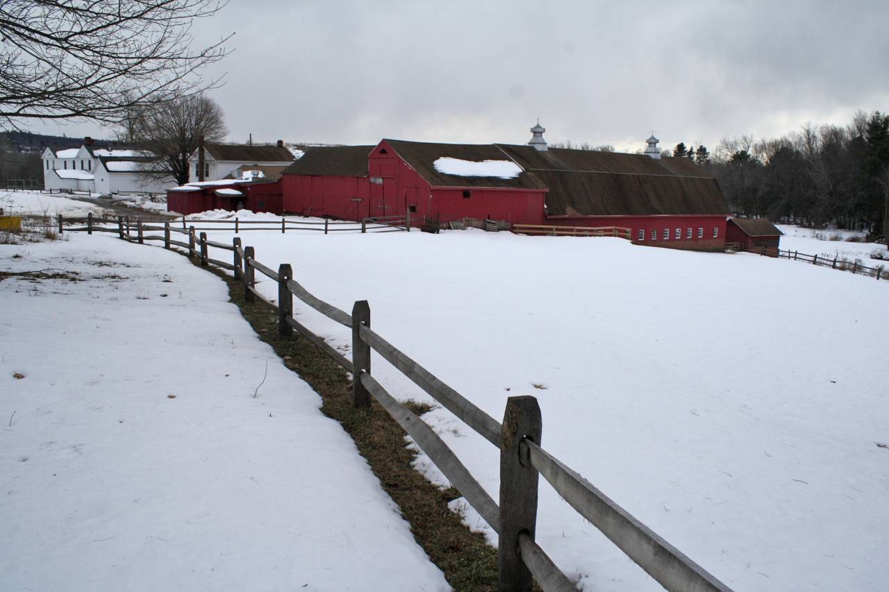
This dairy barn complex comprises three connected buildings. The largest section is a 1937 gambrel-roofed barn of the ground level stable type, 40’ x 90’, built on a poured concrete foundation with brick and frame walls, with its ridge-line oriented east-west, and clad in horizontal wood Dutch lap siding. Two concrete silo foundations are located at the northeast corner, and two metal ventilators topped by weather vanes are mounted on the roof ridge.
Exterior:
The horizontally massed south eave-side, level with grade, has brick walls extending up to the window sills, and displays a long, even row of 9-pane hopper stable-type windows. Adjacent to the south wall is a gable-roofed 1-story milk room (now converted to restrooms) with its ridge-line east-west parallel to the main gambrel roof. The milk room is connected by a passageway to the main barn. Due to the sloping site, the barn gains a higher foundation at its west gable-end, where hinged barn doors provide access; a sliding hay door to the loft is located above, and a panel of four 6-pane windows with a single window above, are in the gable peak. The east gable-end of this block is attached to the connected wing to the east.
Interior:
The main floor interior consists of an open dairy stable with a central, concrete-floored aisle (metal cow stanchions have been removed). Two longitudinal wood girders support the upper loft level floor, and these are carried on two rows of steel columns. The lower exterior walls are of exposed brick with the upper wall surfaces finished in flush wood paneling between the hopper windows. The ceiling is flush wood planking; all wood surfaces are painted. A pair of hinged doors at the west end leads to the exterior where a concrete ramp transitions to the pasture. An opening in the east end connects to the adjacent block to the east.
The upper loft level is a typical clear-span open space framed with canted scissor trusses meeting at the peak, these formed from sawn dimension lumber. Notable is the use of trusses at every rafter where some barns were framed with trusses at intervals and common rafters between. Enclosed shafts connect from the lower level to the metal ventilators, and framing to protect trap doors for pitching hay down to the lower level, can be seen on both sides. A continuous track for a hay fork is suspended from the ridge, extending through to the older wing to the east.Barn – bank barn wing:
At its east gable end, the gambrel block adjoins an earlier L-shaped bank barn, built in two blocks, possibly from recycled parts, and entered at grade on the south (lower level) and north (upper level). This appears to be a hybrid of two structures built a different times – an English and a New England block. Clad in vertical barn board, this building is a pegged square rule post and beam structure, fabricated with a combination of hewn and milled timbers including rafters of sawn dimension lumber.
The northern block of this building, a 35’ x 40’ structure, stands on a very deep fieldstone foundation that is banked into the slope. Its ridge-line is oriented east-west, aligning with that of the gambrel block abutting on the west. The interior structure consists of pairs of full-height posts which form three aisles and which support purlin plates carrying the sawn rafters. At the east side, part of the south pitch of the roof is truncated by the extension of the east pitch of the intersecting wing of the southern block. This northern block has a pair of hinged doors centered in the gable-end – its framing and door layout mark it as a New England barn, possibly of the late-19th century. There is a triangular attic window or vent opening high in the gable.
The southern block is a four-bay gable-roofed section – an extended English barn, 30’ x 40’, that is perhaps the oldest part of this complex. It stands perpendicular to the northern block, with its ridge-line oriented north-south. An open bay entry is located on the west side at the basement level. To the south of this opening there is an enclosed portion with a sliding door and a hay door above. The sliding door provides access to a basement area with three stable windows in the west side (one in the door) and four more in the south gable-end where the wall is partially exposed as grade rises from west to east. The rising grade along the south side transitions to the upper grade-level of the east side. A large triangular hay hood projects over the south gable-end and a pair of diagonally-sliding hay doors is set into the upper part of the attic gable. On the east eave-side, access to the main level is by two pairs of hinged doors with iron strap hinges, located in the second and fourth bays (from south to north). This east eave-side is flush with the gable-end of the northern block.• Historical or Architectural importance:
Applicable Connecticut State Register Criteria:
1. Associated with the lives of persons significant in our past;
2. Embodying the distinctive characteristics of a type, period, or method of construction.The period of greatest agricultural significance is that of the Town Poor Farm, donated by Amos Eno. The construction of the major farmstead structures occurred during this time, including the 19th-century post and beam framed barns, the 1937 gambrel dairy barn, the bunkhouse, and other outbuildings. The working farm complex and surrounding agricultural land preserve the cultural landscape of the historical farmstead.
Field Notes
Listed on the State Register of Historic Places 6/04/2014.
- Use & Accessibility
Use (Historic)
Use (Present)
Exterior Visible from Public Road?
Yes
Demolished
n/a
Location Integrity
Original Site
- Environment
Related features
Environment features
Relationship to surroundings
This site, formerly the Town Poor Farm, is located on both sides of Wolcott Road, a local road which runs northeastward from Hopmeadow Street (US Route 202/CT Route 10) to Hartford Avenue (CT Route 189). For purposes of description, Wolcott Road will be taken as east-west. The farmstead is in the flood-plain of the Farmington Rive. The farmstead includes a 9.13-acre parcel on the north side of the road, where the farmstead buildings are located, and another 91-acre parcel of agricultural land to the south, extending to the bank of the Farmington River. Munnisunk Brook runs southward along the west border of the northern parcel and through the center of the southern acreage, toward the Farmington River.
The surrounding landscape is a mix of historical agricultural land, where tobacco farming has been a focus of activity, and residential development from the mid- to late-20th century.The Farmhouse associated with this site is located at the southeast part of the northern parcel, with its south eave-side side facing Wolcott Road. The oldest portion of this large building is a rectangular, center-hall Federal-period house (18’ x 35’), which fronts Wolcott Road. The symmetrical five-bay façade features an imposing entry notable for its transom and sidelights, designed with an intricate leading pattern of connected circles. The entire entry is set in a shallow recess framed by pilasters and entablature. A triple window framed by pilasters appears above. The gable ends are each enclosed by a returning triangular cornice and punctuated by attic windows shaped as elliptical fans set in flush-board siding. A corbelled brick chimney rises near the west gable end. The building has been extended rearward with a large, midsection that incorporates a recessed porch (facing west) and a rear gabled section to the north, roughly mirrors the original front building. The midsection has a flat-roofed center at the elevation of the adjacent roof ridges, and pitched sections sloping down to the west and east. The siding is clapboards with corner board trim, painted white. Roofing is asphalt shingles. The building was converted to multi-family use in 1993-94.
To the rear (north), a narrow wood-framed outbuilding structure, 20’ x 45’, has its ridge-line east-west. It includes a 1 ½-story block at the west end, a 1-story Woodshed or Wagon shed with an open bay in the south eave-side, and contains a privy. Siding is a mix of narrow and wide horizontal clapboard. This connects to the house via a narrow connector and there is a small 15’ x 20’ 1-story ell (off the northeast corner), thus creating a small U-shaped barnyard immediately to the north of the main Farmhouse building.North of the Farmhouse is a gable-roofed 18’ x 36’ 2 ½-story building, the Bunkhouse, built on a stone and brick foundation with its ridge-line oriented east-west parallel to the road. The entrance is located in a small enclosed shed-roofed porch on the south eave-side. The two-bay gable-ends of the building are set under overhanging eaves with full pedimented cornice returns, and finished with a horizontal board infill. The very slight overhang between the first and second story is an unusual feature. Narrow brick chimneys are at the two gable ends – exposed at the east end but interior at the west. Windows are six-over-six double-hung, some replacement sash. Siding is clapboard with narrow cornerboards; the attic pediment has flush-board siding. Roofing is asphalt shingles, and the foundation is mortared fieldstone, visible along the north side.
The next structure to the north of the Bunkhouse is a 1-story gable-roofed Garage building 35’ x 40’ built in 1937, used later as a retail dairy shop during the late 20th century. It has a brick foundation, hinged multi-pane glazed doors, and a shed-roofed utility wing added to the rear. Siding is horizontal Dutch lap siding painted red with white trim; roofing is asphalt shingles.
North and west of the Garage/dairy shop is the main barn (see below).
West of the gambrel-roofed block of the barn is a 15’ x 25’ 1-story Manure shed with its ridge-line oriented east-west. The shed is on a brick foundation partially banked into the hill, which slopes down toward the west.
South of the Manure shed is a former Bull barn.- Typology & Materials
-
Building Typology
Materials
Structural System
Roof materials
Roof type
Approximate Dimensions
n/a
- Source
-
Date Compiled
02/21/2013
Compiled By
Charlotte Hitchcock
Sources
Field notes and photographs by Charlotte Hitchcock, 2/22/2013.
Aerial Mapping:
http://www.bing.com/maps - accessed 9/6/2011.Carley, Rachel, Historic Resource Inventory of Agricultural Buildings, Simsbury, 2013.
Sexton, James, PhD, Survey Narrative of the Connecticut Barn, Connecticut Trust for Historic Preservation, Hamden, CT, 2005, http://www.connecticutbarns.org/history.
Visser, Thomas D.,Field Guide to New England Barns and Farm Buildings, University Press of New England, 1997.
- PhotosClick on image to view full file
-