Barn Record Newtown
RETURN TO ‘FIND BARNS’
- Overview
-
Designations
n/a
Historic Significance
Architectural description:
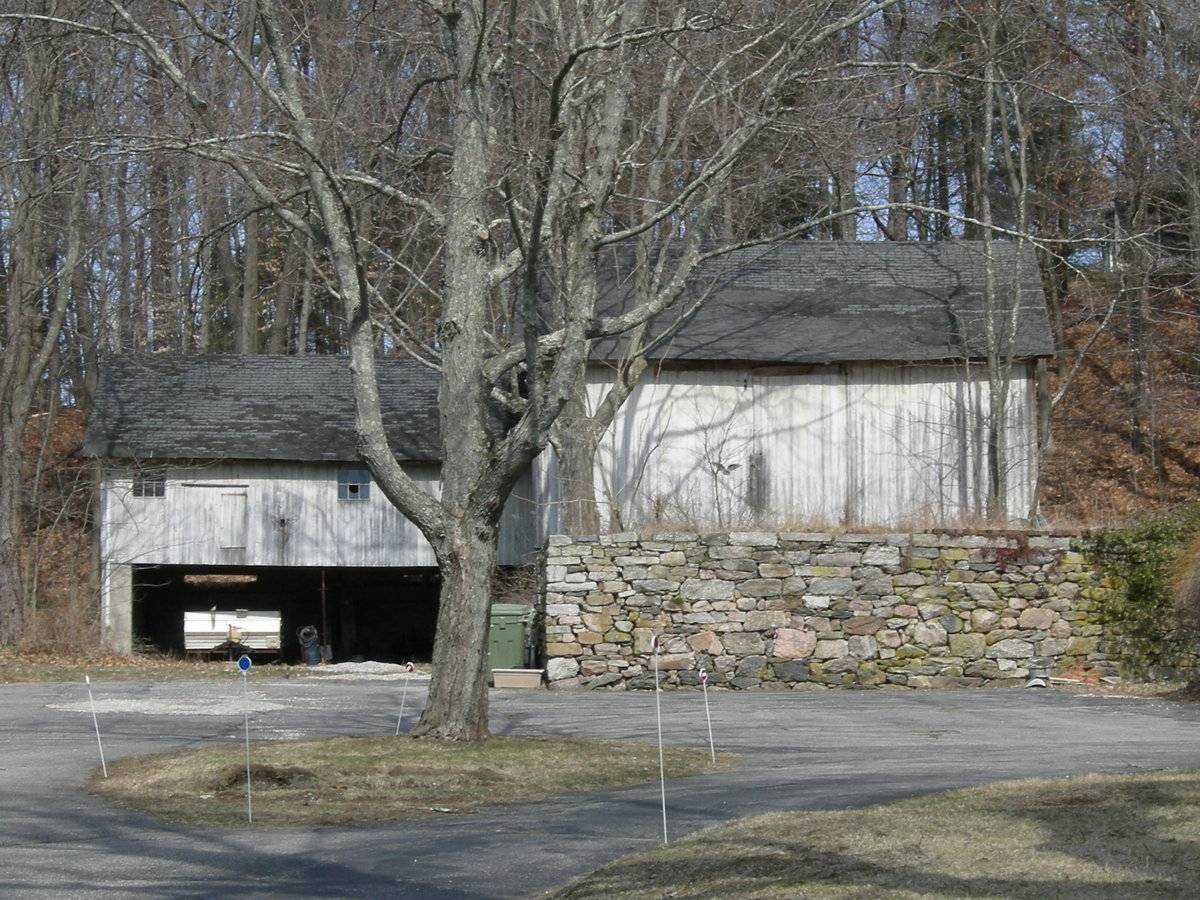
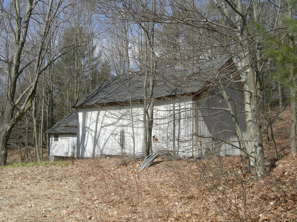
This a 1 ½ story, eave-entry barn with a gable-roof addition. The ridge-line of the barn is roughly parallel to this portion of Berkshire Road, which runs approximately east-west. The main entry is probably on the rear, north side of the barn. The south eave-side of the barn appears to be blank, although perhaps a double-height door is disguised among the vertical sideboards in the center bay of the barn. There is no exterior track for a sliding door and no hinges are visible. The east gable-side of the barn is blank except for a small window in the gable attic. The gable-roof addition is two bays long and occupies the north half of the west gable-side of the barn. It has a lower story because of the difference in grade. The lower story is open on the south eave-side. The upper story has a hinged door in the west bay and a fixed, six-pane window on the far west side. There is a single, six-pane window on the west side of the east bay. The barn has vertical siding which was painted white at one time. The roof is covered with asphalt shingles.
Historical significance:
The oldest barns still found in the state are called the “English Barn,” “side-entry barn,” “eave entry,” or a 30 x 40. They are simple buildings with rectangular plan, pitched gable roof, and a door or doors located on one or both of the eave sides of the building based on the grain warehouses of the English colonists’ homeland. The name “30 by 40” originates from its size (in feet), which was large enough for 1 family and could service about 100 acres. The multi-purpose use of the English barn is reflected by the building’s construction in three distinct bays - one for each use. The middle bay was used for threshing, which is separating the seed from the stalk in wheat and oat by beating the stalks with a flail. The flanking bays would be for animals and hay storage.
The 19th century saw the introduction of a basement under the barn to allow for the easy collection and storage of a winter’s worth of manure from the animals sheltered within the building. The bank barn is characterized by the location of its main floor above grade, either through building into a hillside or by raising the building on a foundation. This innovation, aided by the introduction of windows for light and ventilation, would eventually be joined by the introduction of space to shelter more animals under the main floor of the barn.Field Notes
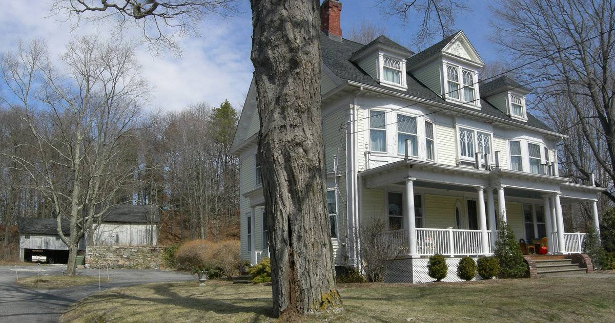
Date of house: 1905 Next door to the south from Mitchell & Goodrich: “Here is the [1740] homestead of Capt. Gould Curtiss ... He was an officer in a militia established by the Colonial government to protect settlers against Indian attacks. They didn't have to worry since the Pohtatuks were docile and even wanted to become Christians. (In Newtown, Curtis and Curtiss are the same family.)” No. 45 is the center of a row of 3 large homes across from the Curtis Packaging Co. No. 43 to the north (1873) of Italianate style. Possibly all Curtis family? Sources: “Touring Newtown’s Past: the Settlement and Architecture of an Old Connecticut Town;” Mary Mitchell and Albert Goodrich, Newtown Historical Society, Newtown, Connecticut, 1996, p. 54, 122-3 pre-1826 House Inventory. Newtown Assessor’s Records. BRN5 2S Barn 600 S.F. BRN5 2S Barn 768 S.F. SHD1 Shed 100 S.F. SHD3 Shed Metal 80 S.F.
- Use & Accessibility
Use (Historic)
Use (Present)
Exterior Visible from Public Road?
Yes
Demolished
n/a
Location Integrity
Unknown
- Environment
Related features
Environment features
Relationship to surroundings
The barn is behind and to the north of the house with which it is associated. The ridge-line of the house is parallel to the ridge-line of the barn. The house faces Berkshire Road. The 1.01-acre property and the residence to the west share a driveway, which forks behind the house into a paved parking area and then makes a circular turn in front of the barn. The barn is built on higher ground at the rear of the property and a stone retaining wall forms the north end of the parking area. There is a yard in front, on the east side and in back of the house. A small, gable-roof shed is found in the rear yard. There is a narrow strip of woodland behind the barn dividing it from an adjacent property to the north. The area surrounding the site is densely developed with patches of woodland. The Curtis Packaging Co. is located across the street from the property, which along with two neighboring houses, may have belonged to the Curtis family.
Map/Block/Lot 44/ 5/ 9/
- Typology & Materials
-
Building Typology
Materials
Structural System
Roof materials
Roof type
Approximate Dimensions
n/a
- Source
-
Date Compiled
11/19/2010
Compiled By
Amy Prescher & Todd Levine, reviewed by CT Trust
Sources
Photographs and field notes by Charlotte Hitchcock 3/18/2008.
Map of Newtown, CT, retrieved on November 19, 2010 from website
http://bing.com/maps/Map of Newtown, CT, retrieved on November 19, 2010 from website http://maps.google.com/
Vision Appraisal Online Database. http://www.visionappraisal.com/databases
Mitchell, Mary, Goodrich, Albert, “Touring Newtown’s Past: the Settlement and Architecture of an Old Connecticut Town;” Newtown Historical Society, Newtown, Connecticut, 1996, p. 54, 122-3 pre-1826 House Inventory.
Sexton, James, PhD; Survey Narrative of the Connecticut Barn, Connecticut Trust for Historic Preservation, Hamden, CT, 2005, http://www.connecticutbarns.org/history.
Visser, Thomas D.,Field Guide to New England Barns and Farm Buildings, University Press of New England, 1997.
“Touring Newtown’s Past: the Settlement and Architecture of an Old Connecticut Town;” Mary Mitchell and Albert Goodrich, Newtown Historical Society, Newtown, Connecticut, 1996, p. 54, 122-3 pre-1826 House Inventory.
- PhotosClick on image to view full file
-