Barn Record Bethany
RETURN TO ‘FIND BARNS’- Building Name (Common)
- n/a
- Building Name (Historic)
- n/a
- Address
- 76 Litchfield Turnpike (Rte 69), Bethany
- Typology

- Overview
-
Designations
n/a
Historic Significance
Architectural description:
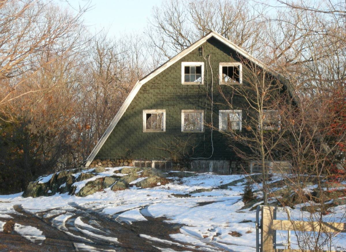
This is a two-story, ground-level stable barn. The main facade faces west and the ridge-line of the barn is perpendicular to this portion of the Litchfield Turnpike, which runs approximately north-south. The rear, east gable-side of the barn appears to be missing due to demolition or dilapidation. At one time another barn building or shed ran from the east gable-side of the barn to the south. A small courtyard was formed between that block and a shed-roof wagon or equipment shed across from the south eave-side of the barn. An outcropping of rock rises in front of the west gable-side of the barn. The grade is much lower behind the outcropping so that the lower level of the barn is not visible from the street. It consists of a cobblestone foundation. Three sets of what appear to be paired six-pane windows, all with their lintels aligned along the girt line, are inserted in the masonry wall of the west gable-side of the barn. Perhaps the central pair could be a hinged door with windows. The gable attic is illuminated by two rows of two and four fixed, six-pane windows with trim. The glazing is broken or missing in at least three of the windows. The gable attic has green asphalt shingles. The roof is covered with asphalt shingles.
Historical significance:By the early 20th century agricultural engineers developed a new approach to dairy barn design: the ground-level stable barn, to reduce the spread of tuberculosis bacteria by improving ventilation, lighting, and reducing the airborne dust of manure. A concrete slab typically serves as the floor for the cow stables. Many farmers converted manure basements in older barns into ground-level stables with concrete floors. Some older barns were jacked up and set on new first stories to allow sufficient headroom. With the stables occupying the entire first story, the space above serves a a hayloft. By the 1920s most ground-level stable barns were being constructed with lightweight balloon frames using two-by-fours or two-by-sixes for most of the timbers. Novelty or tongue-and-groove beveled siding is common on the walls, although asbestos cement shingles also were a popular sheathing. Some barns have concrete for the first-story walls, either poured in place or built up out of blocks. The gambrel roof design was universally accepted as it enclosed a much greater volume than a gable roof did, and its shape could be formed with trusses. Also see entry for Pole Barn.
Field Notes
Gambrel-roofed barn with cobblestone masonry base. Many barns in this area are used for horses. House built in ca. 1800. The barn lot appears to be used by the adjacent horse farm to the north of 76 Litchfield Turnpike. It is not included as an outbuilding on the Field Card filed for the house pictured, although it appears to belong in that historical context. Perhaps the barn is condemned or the neighbor has purchased the land on which the barn stands.
- Use & Accessibility
Use (Historic)
Use (Present)
Exterior Visible from Public Road?
1
Demolished
n/a
Location Integrity
Unknown
- Environment
Related features
Environment features
Relationship to surroundings
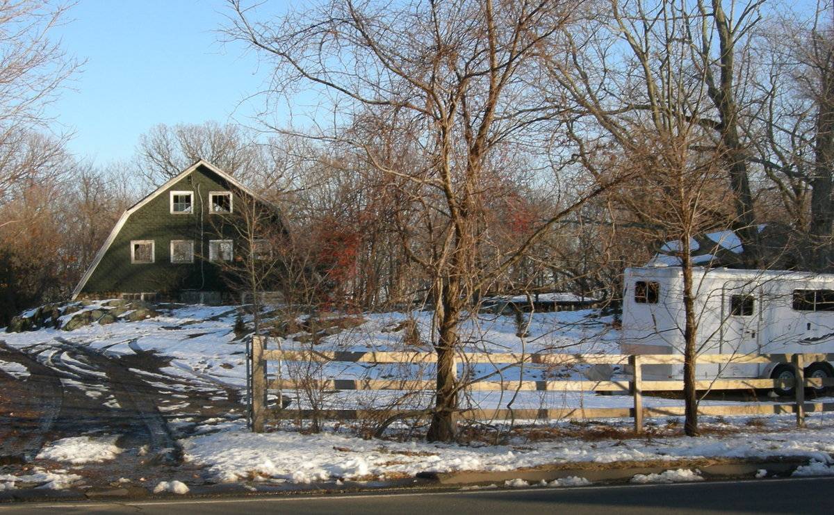
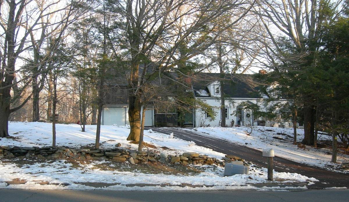
The barn is to the northeast of the house with which it is associated. The ridge-line of the house is roughly perpendicular to the ridge-line of the barn. The house fronts the Litchfield Turnpike (Route 69) behind a stone wall running north-south along the road. The barn is set back from the road behind a driveway that enters through a metal gate aligned with the west gable-facade of the barn and leads to a wagon or equipment shed on its south side. The gate connects to a split-rail fence which extends to the south and continues around the northwest corner of the 1.23-acre property. The house has a separate driveway which leads to a garage attached to its north gable-side. The house, built in ca. 1800, is a cape withe several small additions including a small open porch on the south gable-side and a walkway leading to an octagonal gazebo in the yard to the south. The appears to be some debis from former outbuildings or additions on the rear, east gable-side of the barn. The house is well-shaded by trees and there are woodlands surrounding the property. There is a large horse farm on the adjacent property to the north. The area surrounding the site is residential, agriculture, open space and woodland.
Map 126/40
- Typology & Materials
-
Building Typology
Materials
Structural System
Roof materials
Roof type
Approximate Dimensions
n/a
- Source
-
Date Compiled
01/21/2011
Compiled By
Amy Prescher & Todd Levine, reviewed by CT Trust
Sources
Photographs and field notes by Charlotte Hitchcock.
Map of Bethany, CT, retrieved on January 21, 2011 from website
http://bing.com/maps/Map of Bethany, CT, retrieved on January 21, 2011 from website http://maps.google.com/
eQuality Valuation Servies, LLC Database
http://www.prophecyone.us/fieldcard.php?property_id=1826982Sexton, James, PhD; Survey Narrative of the Connecticut Barn, Connecticut Trust for Historic Preservation, Hamden, CT, 2005, http://www.connecticutbarns.org/history.
Visser, Thomas D.,Field Guide to New England Barns and Farm Buildings, University Press of New England, 1997.
- PhotosClick on image to view full file
-