Barn Record Bethany
RETURN TO ‘FIND BARNS’- Building Name (Common)
- Mad Mares Farm
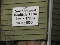
- Building Name (Historic)
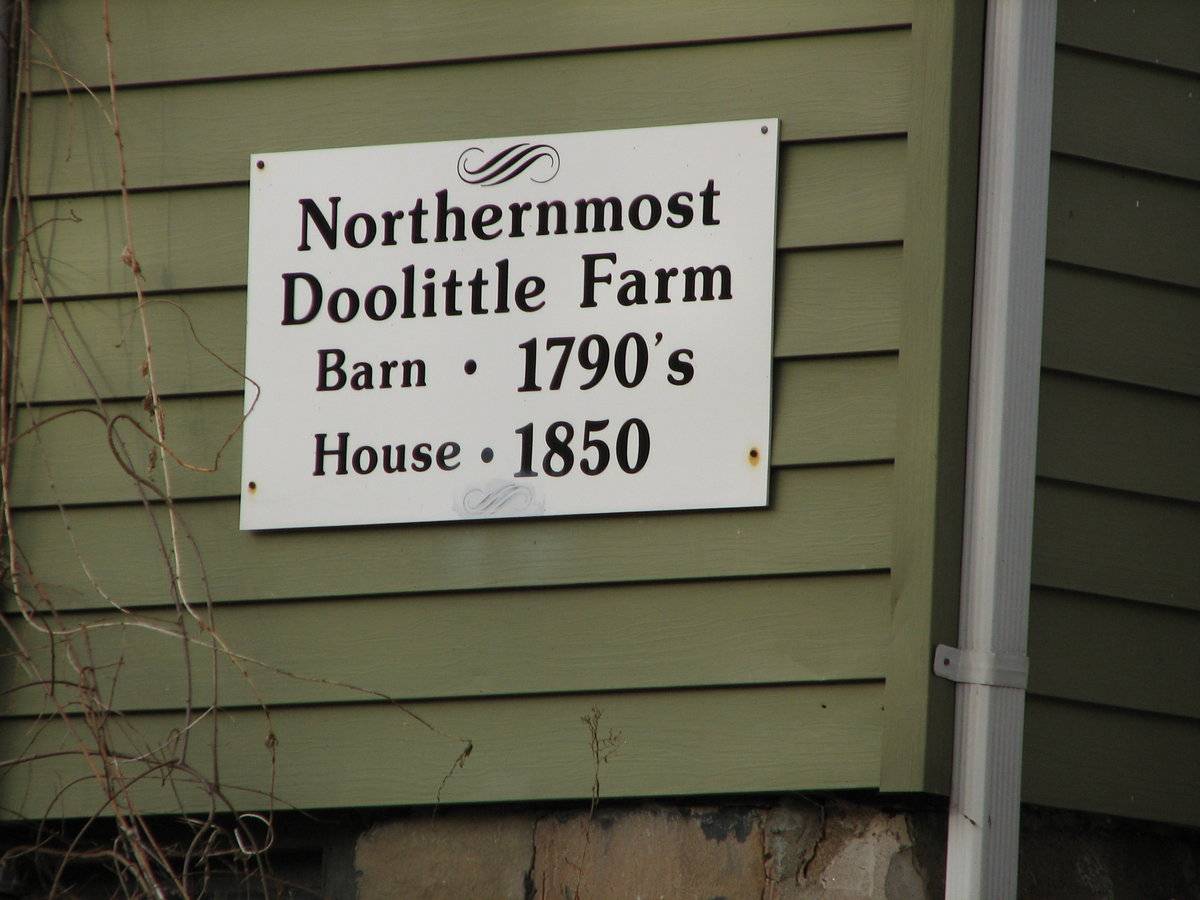
- Northernmost Doolitte Farm
- Address
- 329 Downs Road, Bethany
- Typology

- Overview
-
Designations
Historic Significance
Architectural description:
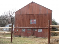
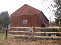
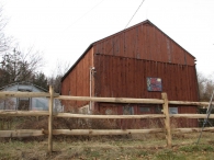
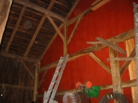
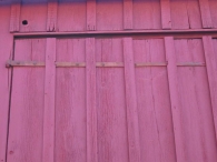
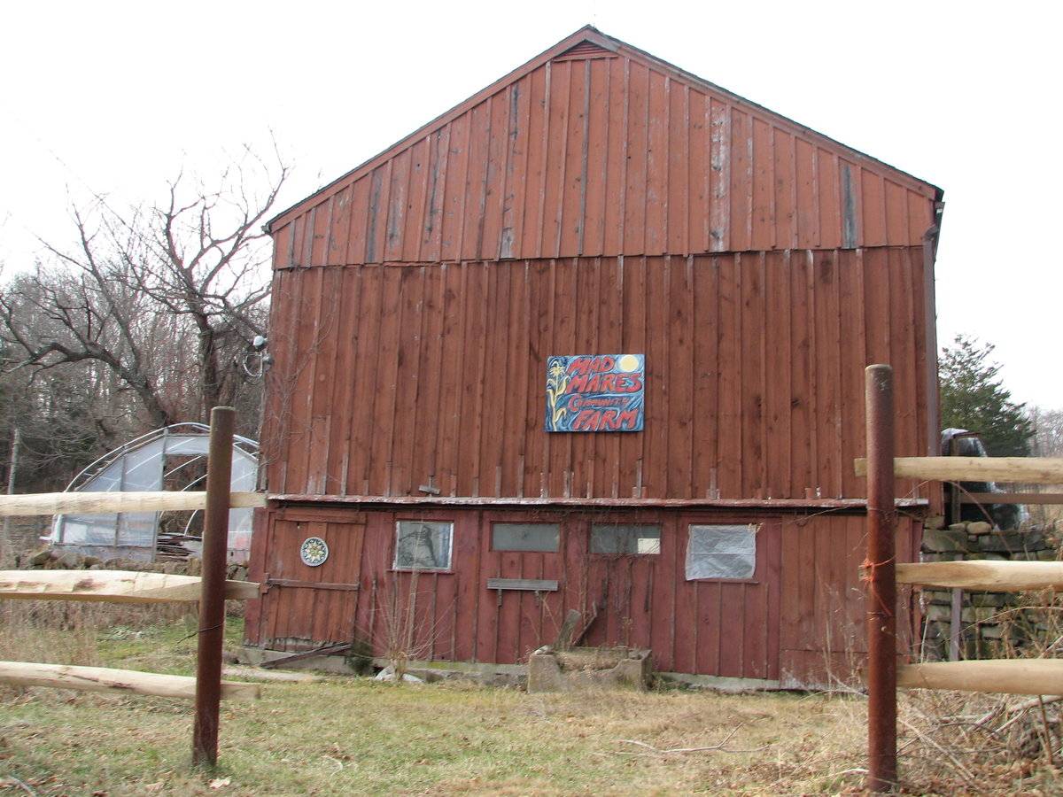
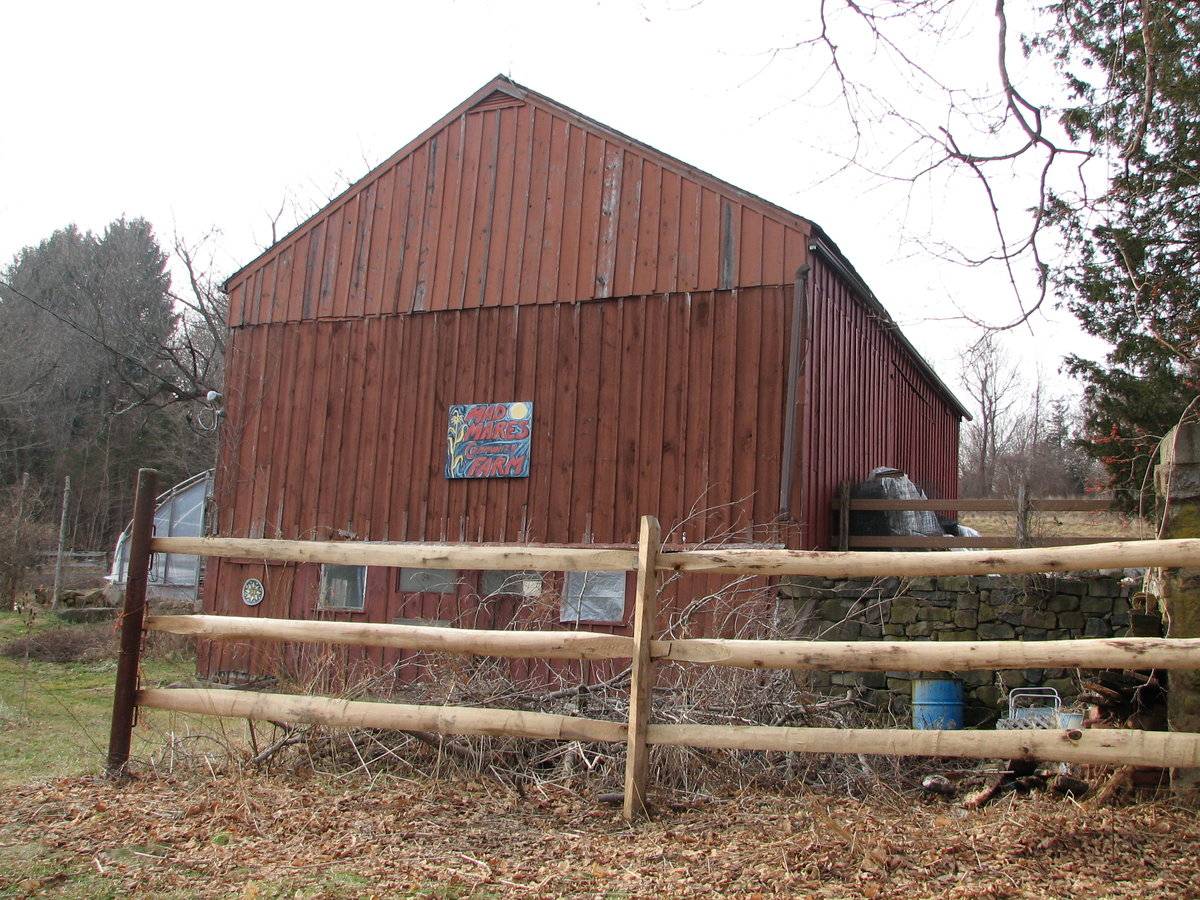
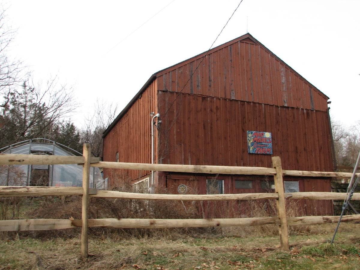
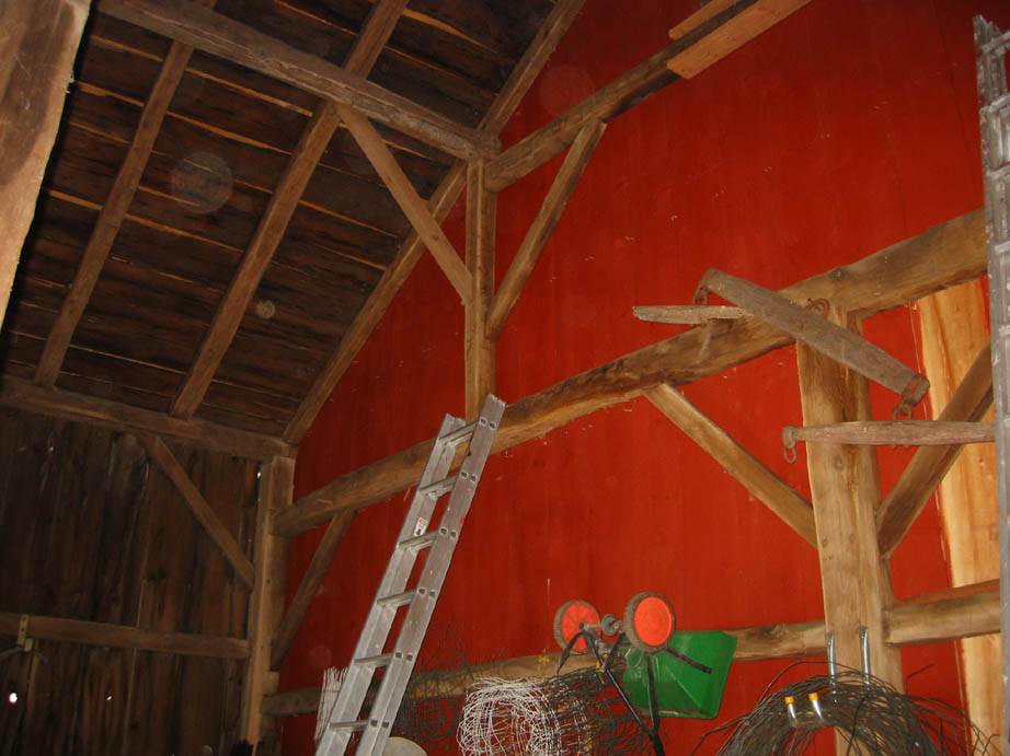
This is a 1 1/2-story, tripartite, eave-entry bank barn. The main facade faces north and the ridge-line of the barn is perpendicular to this portion of Downs Road, which runs approximately north-south. The main entry is a pair of hinged doors in the middle of three bays in the north eave-facade. The long strap hinges of the doors run beneath the battons. The rest of the north eave-facade is blank. The grade decreases sharply on the east gable-side of the barn so that the basement story is exposed. There is a stone retaining wall set at the northeast corner of the barn and extending to the north to mitigate the difference. There are two exterior sliding doors on the far ends of the basement story of the east gable-side of the barn. Between them are two pairs of fixed windows: the inner windows are narrow with a horizontal orientation, and the outer windows are larger and nearly square. A thin hood covering the door track extends from end to end on the east gable-side of the barn. The rest of the east-gable side of the barn is blank. The jump in grade occurs behind the east bay of the south eave-side of the barn, where a stone retaining wall extends to the south. There is an elaborate set of three windows, a fixed eight-over-eight pane window flanked by a four-over-four, double-hung window on either side, in the exposed basement story on the far east end. The rest of the south eave-side of the barn has only one fixed, six-pane window just west of center and two hinged hay doors in the upper register. The barn has board-and-batten siding painted red with white trim on the windows of the basement story of the south eave-side of the barn only. The roof may have had wooden shingles recently, but it now appears that the roof is covered with asphalt shingles.
Historical significance:The oldest barns still found in the state are called the “English Barn,” “side-entry barn,” “eave entry,” or a 30 x 40. They are simple buildings with rectangular plan, pitched gable roof, and a door or doors located on one or both of the eave sides of the building based on the grain warehouses of the English colonists’ homeland. The name “30 by 40” originates from its size (in feet), which was large enough for 1 family and could service about 100 acres. The multi-purpose use of the English barn is reflected by the building’s construction in three distinct bays - one for each use. The middle bay was used for threshing, which is separating the seed from the stalk in wheat and oat by beating the stalks with a flail. The flanking bays would be for animals and hay storage.
The 19th century saw the introduction of a basement under the barn to allow for the easy collection and storage of a winter’s worth of manure from the animals sheltered within the building. The bank barn is characterized by the location of its main floor above grade, either through building into a hillside or by raising the building on a foundation. This innovation, aided by the introduction of windows for light and ventilation, would eventually be joined by the introduction of space to shelter more animals under the main floor of the barn.
Field Notes
Listed on the State Register of Historic Places 12/04/2013. Two field cards. One indicates that the house is a ranch from 1920. The other is a colonial from 1850. While this barn has long been thought to be from late in the 18th century or early in the 19th century the construction details and siting suggest that it was built at the same time as the associated house, ca. 1850. James Sexton The barn sits close to the road on a hill across a driveway from the associated house and across the road from a former carriage barn. James Sexton
- Use & Accessibility
Use (Historic)
Use (Present)
Exterior Visible from Public Road?
Yes
Demolished
n/a
Location Integrity
Unknown
- Environment
Related features
Environment features
Relationship to surroundings
The barn is to the southwest of the house with which it is associated. The ridge-line of the house is parallel to the ridge-line of the barn. The southeast gable-facade of the house, built in ca. 1850, fronts Downs Road. The barn is set back slightly from the road. A stone wall runs northwest-southeast on the northeast property line of the 4.25-acre lot. A driveway from the road runs to the west between the house and barn, connecting to a garage at the far west end of the house and a paved parking area in front of the north eave-facade of the barn. There is a small gable-roof shed near a vegetable garden on the west side of the garage. A greenhouse sits in front of the south eave-side of the barn. The area behind the building site appears to be cleared land mixed with brush. There is a small structure that resembles a cottage more than an outbuilding near the south border of the property (ranch mentioned in Assessor’s file card). There is woodland at the far end of the property to the northwest. The area surrounding the site is rural, residential, light agriculture, light open space and woodland.
Map 130/15
- Typology & Materials
-
Building Typology
Materials
Structural System
Roof materials
Roof type
Approximate Dimensions
30' x 40' FRAME BARN c1790 1140 sf. AVERAGE SHED SHED c1950 121 sf.
- Source
-
Date Compiled
01/11/2011
Compiled By
Amy Prescher & Todd Levine, reviewed by CT Trust
Sources
Photographs and field notes by James Sexton.
Map of Bethany, CT, retrieved on January 11, 2011 from website
http://bing.com/maps/Map of Bethany, CT, retrieved on January 11, 2011 from website http://maps.google.com/
eQuality Valuation Servies, LLC Database
http://www.prophecyone.us/fieldcard.php?property_id=1826523Sexton, James, PhD; Survey Narrative of the Connecticut Barn, Connecticut Trust for Historic Preservation, Hamden, CT, 2005, http://www.connecticutbarns.org/history.
Visser, Thomas D.,Field Guide to New England Barns and Farm Buildings, University Press of New England, 1997.
- PhotosClick on image to view full file
-