Barn Record Ashford
RETURN TO ‘FIND BARNS’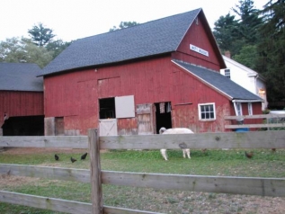
- Overview
-
Designations
n/a
Historic Significance
Architectural description:
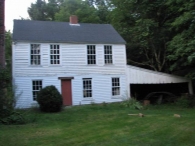
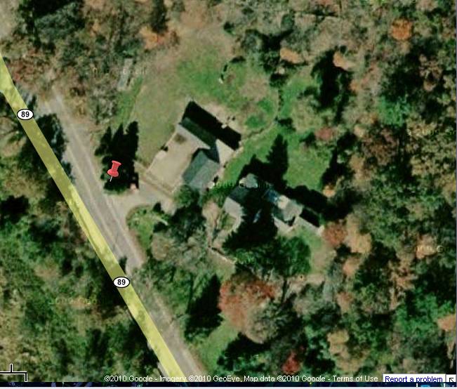
Two 1 and 1/2 story gable-roofed barns are sited perpendicular to each other, forming the north and east sides of a fenced paddock close to the east side of the road. The house is located east of the barn complex; all are at a diagonal to the direction of the road which appears to have been straightened over time.
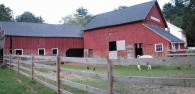
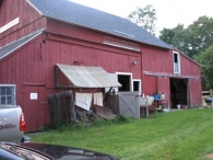
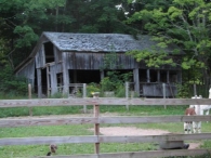
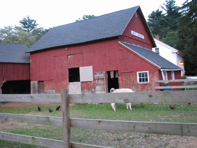
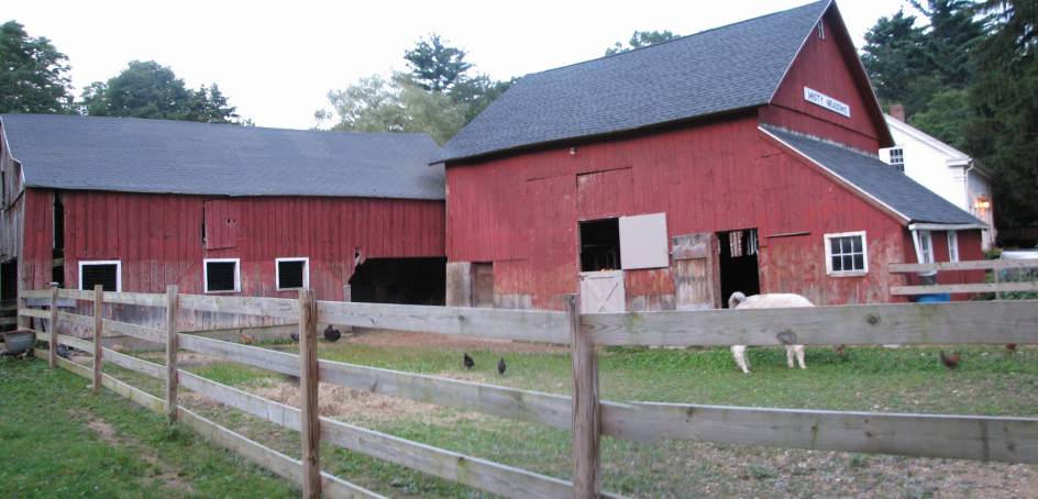
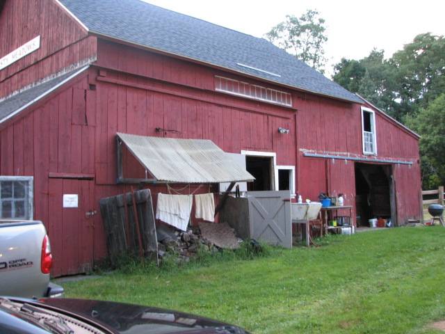
Barn A is the gable-roofed eave-entry barn on the east side of the paddock, with shed additions on both gable-ends. The ridge line runs roughly north-south.
The east eave-side, facing the farmhouse, has been altered, but the presence of a 14-light transom in the center of three bays and the remains of a sliding door track, suggest a former sliding barn door at this location. Currently there is a smaller hinged door and a sidelight window. Also on the east facade there is a sliding door in the end gable of the north shed addition, with a double hung window above, and a pass-through door in the south shed addition, plus a stable window to its left (south).
The south facade has an attic level with a small vent in the peak and a sign “Misty Meadows Farm.” Below is the steeply-pitched shed roof of the addition. The south eave-facade of the addition has two stable windows. The west side of this addition has a single six-paned stable window. The west eave-side facade of Barn A shows some indication in siding repairs, of a former large centered barn door opening. Currently there is a tall hinged Dutch door in the center bay flanked by shorter hinged doors for livestock (llamas) in the end bays.
Siding is vertical flush boards painted red. Roofing is asphalt shingles.
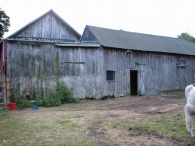
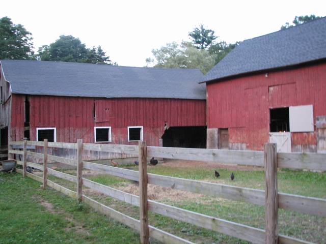
Barn B at the north side of the paddock, is a gable-roofed structure with its ridge line running east-west. The south eave-side facade has three stable window openings at the left (west) end and a wide opening at the right (east) end, appearing likely to be for sheep. The barn overlaps behind Barn A so that the right corner is not visible.
Siding is vertical flush boards painted red on the south side and unpainted on the north side; roofing is asphalt shingles.
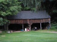
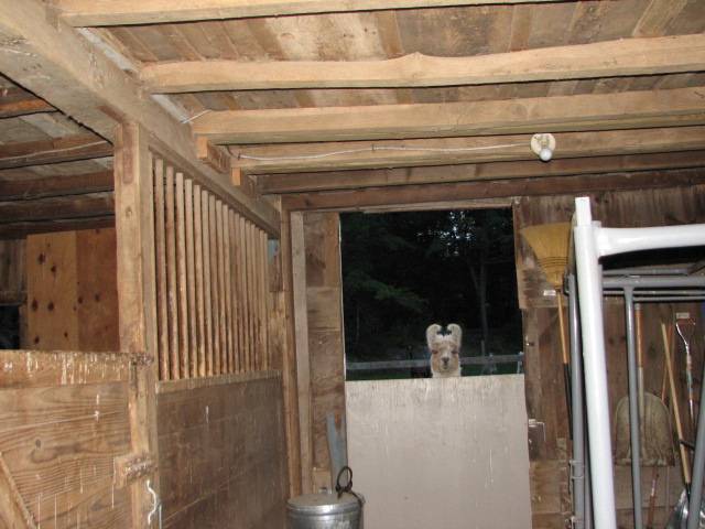
Now used for llamas, it was possibly a sheep barn originally.Building C, D: there are additional outbuildings including a wagon shed and a gable-roofed barn in poor condition. The wagon shed has a gable roof, is five bays wide, and has wide openings in the ground level with a possible loft level above. Siding is unpainted vertical boards; roofing is asphalt shingles.
Historical significance:The oldest barns still found in the state are called the “English Barn,” “side-entry barn,” “eave entry,” or a 30 x 40. They are simple buildings with rectangular plan, pitched gable roof, and a door or doors located on one or both of the eave sides of the building based on the grain warehouses of the English colonists’ homeland. The name “30 by 40” originates from its size (in feet), which was large enough for 1 family and could service about 100 acres. The multi-purpose use of the English barn is reflected by the building’s construction in three distinct bays - one for each use. The middle bay was used for threshing, which is separating the seed from the stalk in wheat and oat by beating the stalks with a flail. The flanking bays would be for animals and hay storage.
Sheep farming was at first undertaken for the meat and wool to be used domestically. Following the English tradition, it was recognized that sheep needed abundant fresh air and easy access to pastures. But the New England climate could cause problems requiring shelter. For larger flocks, farmers tried simple open structures or small hay barns flanked by open sheds. During the early 1800s raising merino sheep for wool became a lucrative activity and a more specialized type of sheep shed was built, still with open doors for the sheep to go in and out. Sheep farming collapsed in the late 1830s, but revived during the Civil War as demand developed for wool to replace cotton and meet military needs. The sheep barn form evolved, with an open shed on the ground floor and a hayloft above.
Historical background:The town of Ashford was incorporated in 1714 and for its first century had the typical scattered settlement on upland ridges which characterized nearly all of Connecticut. The economy was community-subsistence agriculture. Industry was limited to the mills of the agricultural economy – grist, saw, fulling mills.
In the early 19th century, turnpikes and improved roads, along with limited market-oriented agriculture, resulted in some local wealth and settlement nuclei at the major crossroads. Ashford Center, Westford, and Warrenville date from this period. So do the fancy Federal-style houses in these villages and along Route 89 (Mansfield Road) south of Warrenville. Also in this period there existed a short-lived glass factory at Westford.
In the 19th century, the lack of significant waterpower and railroad connections led to stagnation. Its peak population, 1820 (2,778) which had declined to 668 by 1910, was not exceeded until 1980.
In the early 20th century, the declining farms of Ashford were abandoned by their Yankee owners and sold to East European immigrants, notably Slovaks, Bohemians, and Hungarians (Magyars). This transformation of the rural countryside is one of the great stories of modern Connecticut. Today a large portion of the town is descended from these people (Clouette, Township Survey).Field Notes
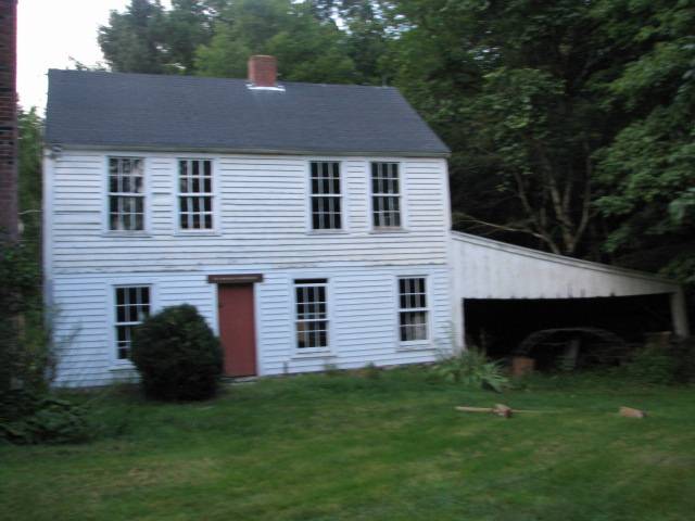
Multiple-building complex. English barn connected to possible sheep shed. Wagon shed. Cobbler shop (vacant in poor condition). Residence built about 1820s; cobbler shop on premises; Ellon House served as town public library from 1860s - 1924.
- Use & Accessibility
Use (Historic)
Use (Present)
Exterior Visible from Public Road?
Yes
Demolished
n/a
Location Integrity
Unknown
- Environment
Related features
Environment features
Relationship to surroundings
Westford Road is now a partially wooded area of old farmhouses, a short distance to the north of the center of Ashford where US Route 44 (formerly the main Boston-Hartford turnpike) passes through town.
- Typology & Materials
-
Building Typology
Materials
Structural System
Roof materials
Roof type
Approximate Dimensions
750, 216, 525, & 960 square feet.
- Source
-
Date Compiled
02/22/2010
Compiled By
Charlotte Hitchcock, reviewed by CT Trust
Sources
Field notes and photographs by Barbara Metsack 12/09/2009.
Town of Ashford Assessor’s Record Map/Lot 25/ A/ 6 (house built 1870, 1.9 acres, barns 750, 216, 525, 960 sf) and 25/ C/ 4 (7.5 acres).Aerial Mapping: Ashford Maps
www.bing.com/maps - accessed 02/22/2010.Bayles, Richard M.; History of Windham County, Connecticut, New York: W.W. Preston, 1889. excerpts available at
< http://www.connecticutgenealogy.com/windham/ashford.htm >.
Clouette, Bruce, National Register of Historic Places, Church Farm, Nomination #270921, 1988. Item No. 88002650 NRIS (National Register Information System) http://pdfhost.focus.nps.gov/docs/NRHP/Text/88002650.pdf
< http://pdfhost.focus.nps.gov/docs/NRHP/Photos/88002650.pdf >Clouette, Bruce, Ashford Township Survey, handwritten manuscript, Connecticut Trust for Historic Preservation, 199x.
Cunningham, Janice, and Ransom, David; Back to the Land: Jewish Farms and Resorts in Connecticut 1890-1945, State of Connecticut Historical Commission and Jewish Historical Society of Greater Hartford, 1998,186 pages.
Sexton, James, PhD, Survey Narrative of the Connecticut Barn, Connecticut Trust for Historic Preservation, Hamden, CT, 2005, http://www.connecticutbarns.org/history.
Visser, Thomas D., Field Guide to New England Barns and Farm Buildings, University Press of New England, 1997.
Misty Meadows Farm: http://mistymeadowsllamas.com/
Historic maps: www.maptech.com
- PhotosClick on image to view full file
-