Barn Record Bolton
RETURN TO ‘FIND BARNS’
- Overview
-
Designations
n/a
Historic Significance
Architectural description:
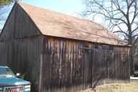
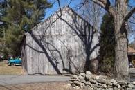
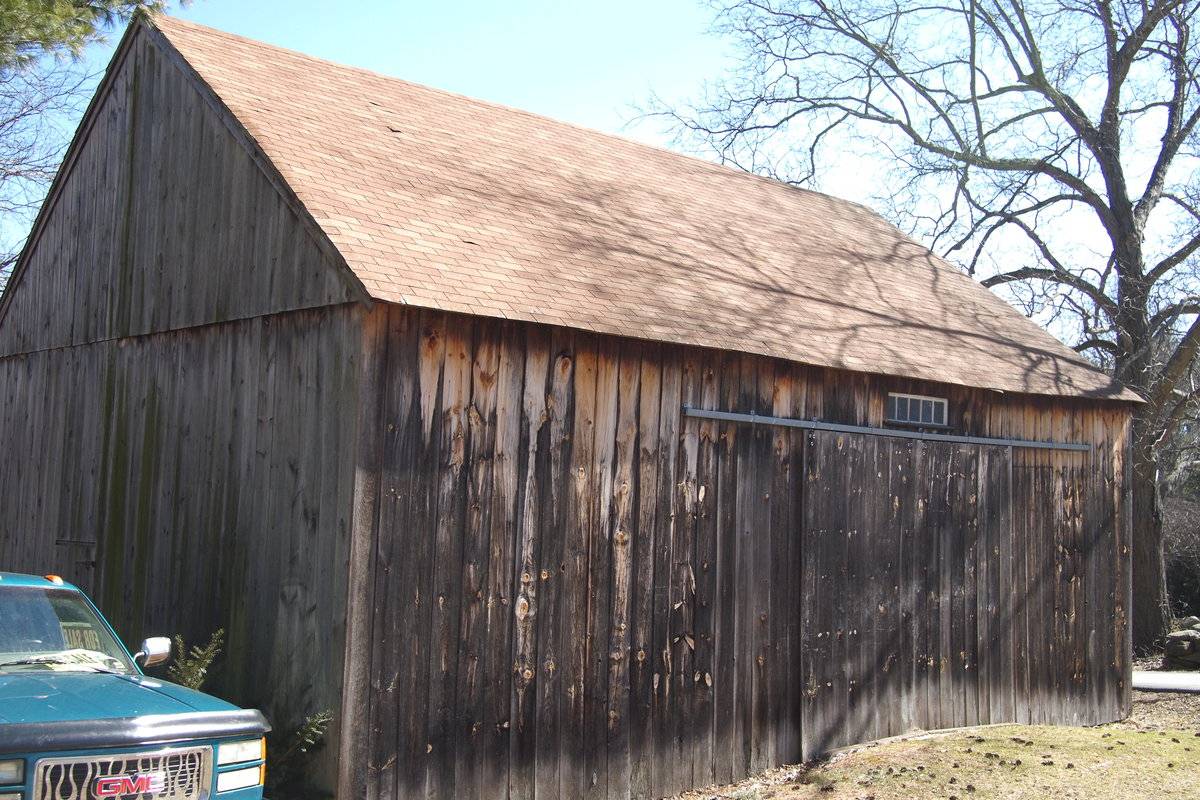
This is a 1 1/2-story, tripartite, eave-entry barn with a gable-roof addition. The main facade faces west and the ridge-line of the barn is roughly parallel to this portion of Hebron Road, which runs approximately north-south. The main entry appears to be a pair of exterior sliding doors in the middle of three bays in the west eave-facade. Above the entry is a five-pane transom. The rest of the west eave-facade is blank. The north gable-side of the barn is blank except for a pass-through door off-center to the east. The east eave-side of the barn has a gable-roof addition extending to the east from the north half of the side of the barn. The north gable-side of the barn is blank. A small portion of the field-stone foundation is evident. The barn has unpainted vertical flush-board siding. The roof is covered with asphalt shingles.
Historical significance:
The oldest barns still found in the state are called the “English Barn,” “side-entry barn,” “eave entry,” or a 30 x 40. They are simple buildings with rectangular plan, pitched gable roof, and a door or doors located on one or both of the eave sides of the building based on the grain warehouses of the English colonists’ homeland. The name “30 by 40” originates from its size (in feet), which was large enough for 1 family and could service about 100 acres. The multi-purpose use of the English barn is reflected by the building’s construction in three distinct bays - one for each use. The middle bay was used for threshing, which is separating the seed from the stalk in wheat and oat by beating the stalks with a flail. The flanking bays would be for animals and hay storage.
Field Notes
Old barn with newer unpainted plank siding. Barn is directly to side of the road.
- Use & Accessibility
Use (Historic)
Use (Present)
Exterior Visible from Public Road?
Yes
Demolished
n/a
Location Integrity
Unknown
- Environment
Related features
Environment features
Relationship to surroundings
The barn is in front of and to the west of the house that it is associated with. The ridge-line of the house is roughly perpendicular to the ridge-line of the barn. The barn fronts Hebron Road. A stone wall runs north-south to the south of the barn, demarcating the east border of the 7.3 acre lot. A driveway from the road runs east, with a paved area to the east of the barn and connects to the west gable-side of the house. To the west of the house is an in-ground pool. There is a yard to the northeast of the house. To the east of the yard is woodland. The area surrounding the site is residential, light agriculture, light open space and woodland.
Map/Block/Lot 00020 00004 00004
- Typology & Materials
-
Building Typology
Materials
Structural System
Roof materials
Roof type
Approximate Dimensions
n/a
- Source
-
Date Compiled
10/14/2010
Compiled By
Amy Prescher & Todd Levine, reviewed by CT Trust
Sources
Photographs and field notes by Jim Pendergrast.
The Capitol Region Council of Governments website. http://www.crcog.org/gissearch/
Map of Bolton, CT, retrieved on October 14, 2010 from website www.zillow.com.
eQuality Valuation Services, LLC Database. http://www.equalitycama.com/tvweb/MainSearch.aspx?city=Bolton
Sexton, James, PhD; Survey Narrative of the Connecticut Barn, Connecticut Trust for Historic Preservation, Hamden, CT, 2005, http://www.connecticutbarns.org/history.
Visser, Thomas D.,Field Guide to New England Barns and Farm Buildings, University Press of New England, 1997.
- PhotosClick on image to view full file
-