Barn Record Bolton
RETURN TO ‘FIND BARNS’
- Overview
-
Designations
n/a
Historic Significance
Architectural description:
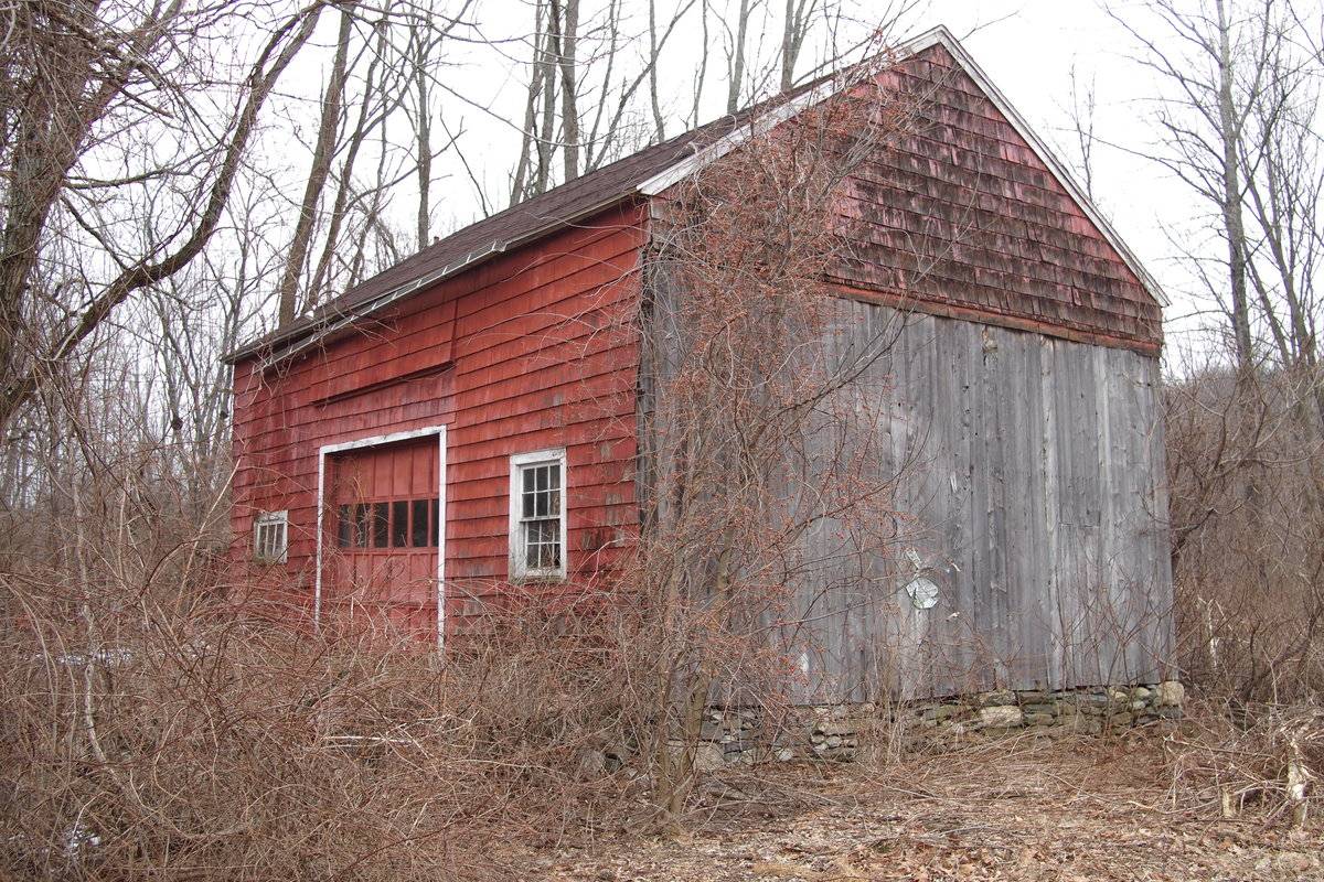
This is a 1 1/2 story, tripartite, eave-entry barn. The main facade faces west and the ridge-line of the barn is perpendicular to this portion of Shoddy Mill Road, which runs east-west. The main entry in the west eave-facade is an overhead garage door in the middle of three bays. The south bay has a centered, six-over-six double-hung window. The north bay has a centered, three-pane hopper window. Above the entry, where a transom would be, is an irregular section of wood shingles that are slightly raised. The south gable-side of the barn is blank. The west eave-side of the barn has windows in north and south bays. The barn has wood shingles siding on the west eave-facade and the gable attic of the south side painted red; beneath the gable attic in the south side of the barn is un-painted vertical flush-board siding. The roof has asphalt shingles. The foundation is un-mortared field-stone.
Historical significance:The oldest barns still found in the state are called the “English Barn,” “side-entry barn,” “eave entry,” or a 30 x 40. They are simple buildings with rectangular plan, pitched gable roof, and a door or doors located on one or both of the eave sides of the building based on the grain warehouses of the English colonists’ homeland. The name “30 by 40” originates from its size (in feet), which was large enough for 1 family and could service about 100 acres. The multi-purpose use of the English barn is reflected by the building’s construction in three distinct bays - one for each use. The middle bay was used for threshing, which is separating the seed from the stalk in wheat and oat by beating the stalks with a flail. The flanking bays would be for animals and hay storage.
Field Notes
Only remaining farm building on 70-acre farm now returned to forest.
- Use & Accessibility
Use (Historic)
Use (Present)
Exterior Visible from Public Road?
Yes
Demolished
n/a
Location Integrity
Unknown
- Environment
Related features
Environment features
Relationship to surroundings
The barn is the last remaining building on this 73 acre site, that extends to the north, northeast and east. The site is mostly woodland. The road bends to the south just south of where the barn is; Shoddy Mill Road continues south and Skinner Road starts at the bend and continues west. The area surrounding the site is residential and woodland. Listed in the assessors card is the following outbuildings: Frame Barn.
Map/Block/Lot 00020 00002 00013- Typology & Materials
-
Building Typology
Materials
Structural System
n/a
Roof materials
Roof type
Approximate Dimensions
n/a
- Source
-
Date Compiled
10/01/2010
Compiled By
Todd Levine, reviewed by the Connecticut Trust
Sources
Photographs and field notes by Jim Pendergrast.
The Capitol Region Council of Governments website. http://www.crcog.org/gissearch/
Map of Bolton, CT, retrieved on October 1, 2010 from website www.zillow.com.
eQuality Valuation Services, LLC Database. http://www.equalitycama.com/tvweb/MainSearch.aspx?city=Bolton
Sexton, James, PhD; Survey Narrative of the Connecticut Barn, Connecticut Trust for Historic Preservation, Hamden, CT, 2005, http://www.connecticutbarns.org/history.
Visser, Thomas D.,Field Guide to New England Barns and Farm Buildings, University Press of New England, 1997.
- PhotosClick on image to view full file
-