Barn Record Waterford
RETURN TO ‘FIND BARNS’
- Overview
-
Designations
n/a
Historic Significance
Architectural description:
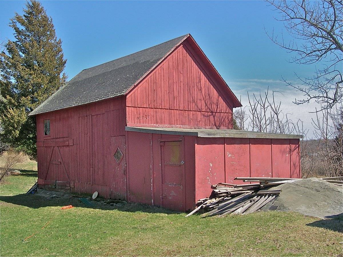
This is a 1 ½ – story eave-entry two-bay barn with a shed-roof addition encompassing the entire length of its west gable-end. The ridge line of the barn runs almost east-west with its east gable-end facing Day ton Road at the angle and the west gable-end facing Hartford Turnpike, Route 85. The main façade of the barn is the north eave-façade with the main entrance towards the east through a pair of Z-braced hinged wagon doors. a single-pane window with trim can be seen above the main entrance, off-centered towards the east. The façade has a second entrance towards the west through a hinged pass-through door which appears to be the weather door insert in the original main entrance to the barn through a double-height hinged wagon door which is no longer functional. The hinged pass-through door has a rhombus single-pane window insert at the center. The north side-wall of the shed-roof addition on the west gable-end of the main barn is flush with the main north eave-façade and has an entrance at the center through a pair of Dutch hinged doors. The west gable-end of the barn has a distinct dropped girt siding divide line separating the gable attic which is lined by deep soffit and cornice board.
The wooden frame of the barn has asphalt shingle roofing and red painted vertical siding walls. The shed-roof addition appears to have metal roofing and asphalt building paper on walls.
Historical significance:The oldest barns still found in the state are called the “English Barn,” “side-entry barn,” “eave entry,” or a 30 x 40. They are simple buildings with rectangular plan, pitched gable roof, and a door or doors located on one or both of the eave sides of the building based on the grain warehouses of the English colonists’ homeland. The name “30 by 40” originates from its size (in feet), which was large enough for 1 family and could service about 100 acres. The multi-purpose use of the English barn is reflected by the building’s construction in three distinct bays - one for each use. The middle bay was used for threshing, which is separating the seed from the stalk in wheat and oat by beating the stalks with a flail. The flanking bays would be for animals and hay storage.
Field Notes
n/a
- Use & Accessibility
Use (Historic)
Use (Present)
Exterior Visible from Public Road?
Yes
Demolished
n/a
Location Integrity
Unknown
- Environment
Related features
n/a
Environment features
Relationship to surroundings
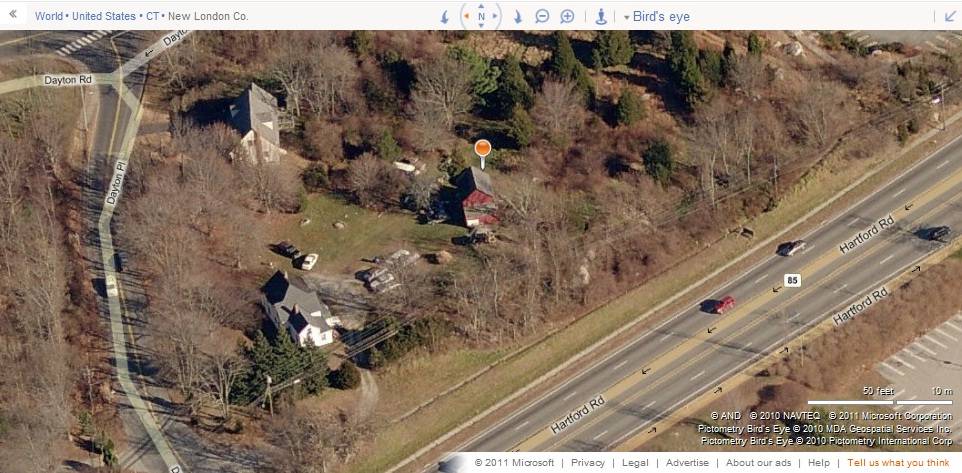
The 3.01 acres property, Account number – 0156200 and Map number- 92, is a corner plot located towards the north of Hartford Turnpike, Route 85, which runs from the southeast to the northwest. Dayton Place bounds the property towards the north while the eastern edge is demarcated by Dayton Road which also runs from the southeast to the northwest. The property is situated in a mixed use area with residential plots towards the east across Dayton Road and commercial units towards the south and the west, across Route 85.
The barn is located towards the western edge of the property with its ridge line running almost east-west, but at an angle to Hartford Turnpike on west and Dayton Road on east. The circa 1890 cape style main residence is located in the northwest corner of the plot while woodland covers the area towards the south and the east of the barn.- Typology & Materials
-
Building Typology
Materials
Structural System
Roof materials
Roof type
Approximate Dimensions
n/a
- Source
-
Date Compiled
03/09/2011
Compiled By
T. Levine and M. Patnaik, reviewed by CT Trust
Sources
Field notes and photographs provided by: Kathya Landeros and William Auwood, 03/30/2010.
Assessors’ records retrieved on March 9th, 2011 from website http://www.equalitycama.com
Photograph/Information retrieved on March 9th, 2011 from website http://www.google.com
Photograph/Information retrieved on March 9th, 2011 from website http://www.bing.com.
Photograph/Information retrieved on March 9th, 2011 from website http://www.zillow.com.
Sexton, James, PhD; Survey Narrative of the Connecticut Barn, Connecticut Trust for Historic Preservation, Hamden, CT, 2005, http://www.connecticutbarns.org/history
Visser, Thomas D.,Field Guide to New England Barns and Farm Buildings, University Press of New England, 1997.
- PhotosClick on image to view full file
-