Barn Record Columbia
RETURN TO ‘FIND BARNS’- Building Name (Common)
- n/a
- Building Name (Historic)
- n/a
- Address
- 5 Erdoni Road, Columbia
- Typology

- Overview
-
Designations
n/a
Historic Significance
Architectural description:
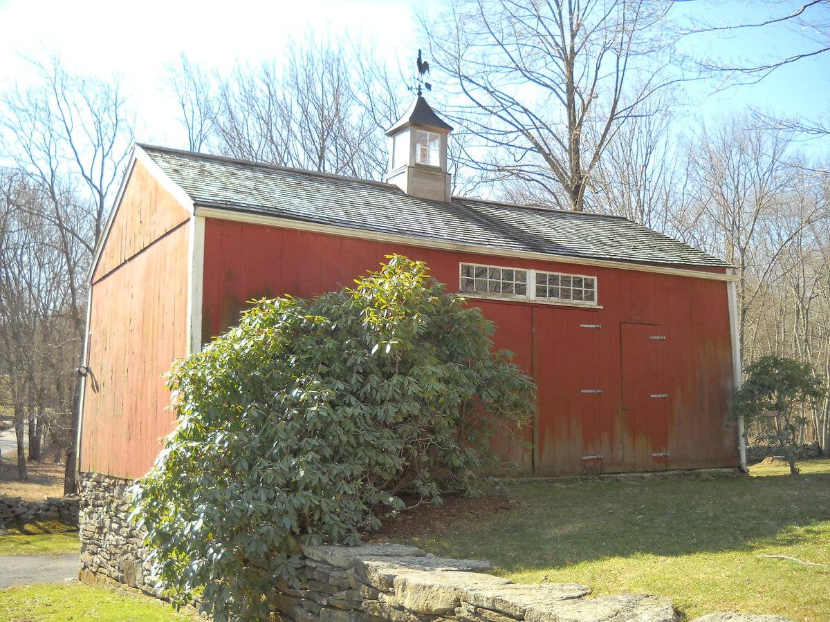
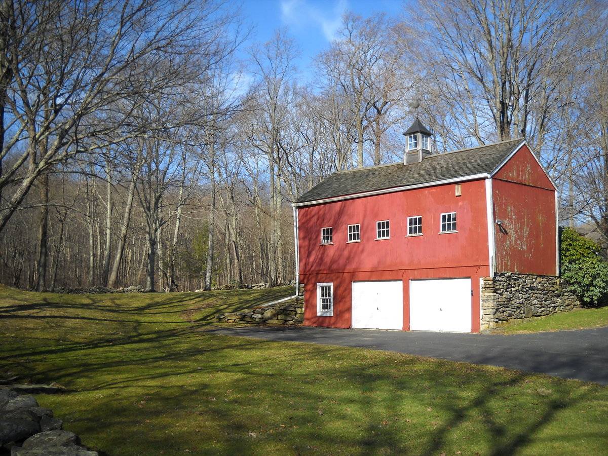
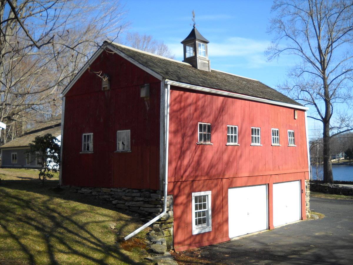
This is a 1 1/2-story side- or eave-entry bank barn. The main facade faces northwest and the ridge-line of the barn is perpendicular to Erdoni Road, which at this point runs approximately southeast-northwest. The main entry is a pair of swinging hinged doors just off-center to the west in the northwest eave-facade. Above each leaf is a five-over-five transom. To the west of the main entry is a pass-through door. The grade of the northeast gable-facade of the barn declines sharply, revealing a basement level, which consists of un-mortared field-stone, and extends to the northwest in the form of a retaining wall. The northeast gable-end of the barn is blank. The southeast eave-side of the barn has two overhead garage doors in the basement level, in the middle and towards the east corner respectively. A six-over-six double-hung window with trim is towards the south corner in the basement level. Above in the main level is a series of five equally spaced six-pane windows. The grade at the southwest gable-end of the barn inclines sharply to the main level. A short retaining knee-wall extends to the south. The southwest gable-end of the barn has a pair of six-pane windows. The barn has vertical flush-board painted red with white trim, cornice boards and corner boards. The foundation is un-mortared field-stone. The roof is covered with asphalt shingles and a cupola is centered atop the ridge-line. The cupola has four-pane windows in each side, a hipped roof and is topped with a weather-vane.
Historical significance:
The oldest barns still found in the state are called the ““English Barn,” “side-entry barn,” “eave entry,” or a 30 x 40. They are simple buildings with rectangular plan, pitched gable roof, and a door or doors located on one or both of the eave sides of the building based on the grain warehouses of the English colonists’ homeland. The name “30 by 40” originates from its size (in feet), which was large enough for 1 family and could service about 100 acres. The multi-purpose use of the English barn is reflected by the building’s construction in three distinct bays - one for each use. The middle bay was used for threshing, which is separating the seed from the stalk in wheat and oat by beating the stalks with a flail. The flanking bays would be for animals and hay storage.
The 19th century saw the introduction of a basement under the barn to allow for the easy collection and storage of a winter’s worth of manure from the animals sheltered within the building. The bank barn is characterized by the location of its main floor above grade, either through building into a hillside or by raising the building on a foundation. This innovation, aided by the introduction of windows for light and ventilation, would eventually be joined by the introduction of space to shelter more animals under the main floor of the barn.
Field Notes
n/a
- Use & Accessibility
Use (Historic)
Use (Present)
Exterior Visible from Public Road?
Yes
Demolished
n/a
Location Integrity
Unknown
- Environment
Related features
Environment features
Relationship to surroundings
The barn is to the south and slightly behind the c1810 house with which it is associated. The ridge-line of the house is perpendicular to the ridge-line of the barn. A small shed is adjacent to the barn to the west. A gable-roof well shelter is to the west of the house. Further west is a gazebo. To the northeast, across the street, is Columbia Lake. The retaining stone wall from the barn extends to the eave-facade of the house. Bordering most of the entire site are stone walls. The total size of the site is 2.63 acres. The area surrounding the site is light residential and woodland.
M/P = 016c//011
- Typology & Materials
-
Building Typology
Materials
Structural System
n/a
Roof materials
Roof type
Approximate Dimensions
576 S.F.
- Source
-
Date Compiled
07/30/2010
Compiled By
Todd Levine, reviewed by the Connecticut Trust
Sources
Photographs and field notes by Janice Thibodeau.
Sexton, James, PhD; Survey Narrative of the Connecticut Barn, Connecticut Trust for Historic Preservation, Hamden, CT, 2005, http://www.connecticutbarns.org/history.
Visser, Thomas D.,Field Guide to New England Barns and Farm Buildings, University Press of New England, 1997.
Map of Columbia, CT, retrieved on July 30, 2010 from website www.bing.com.
Town of Columbia assessors office, 323 Route 87, Columbia, CT 06237.
- PhotosClick on image to view full file
-