Barn Record East Windsor
RETURN TO ‘FIND BARNS’- Building Name (Common)
- n/a
- Building Name (Historic)
- n/a
- Address
- 13 Neiderwerfer Road, East Windsor
- Typology
- Overview
-
Designations
n/a
Historic Significance
Architectural description:
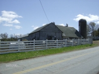
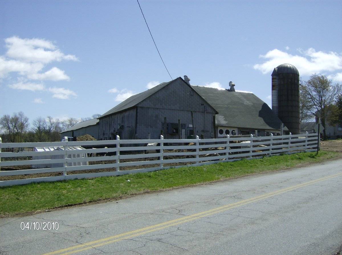
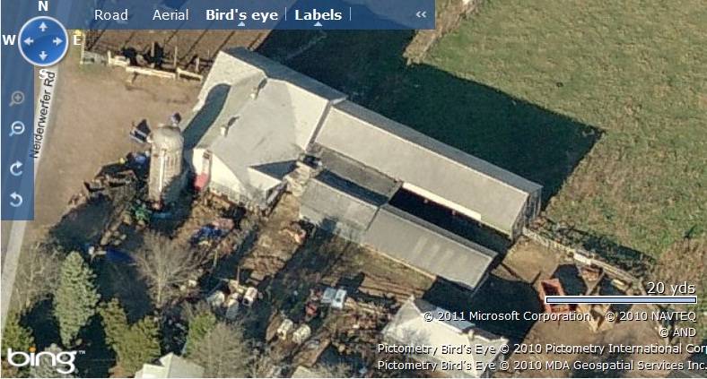
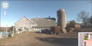
This is a multi-unit barn complex towards the east of Niederwerfer Road consisting of a T-shaped main barn with a concrete silo on its southwest corner. The T-shaped barn is formed by a 1 ½ - story eave-entry gambrel-roof barn intersecting the south eave-side of a 1 1/2 – story gable-roof barn at the center. The ridge line of the main gambrel-roof barn runs north-south, almost parallel to the road while that of the intersecting gable-roof barn runs east-west. The east gable-end of the intersecting gable-roof barn has a rectilinear gable-roof addition with a shed-roof addition on its south eave-side towards the west. The shed-roof addition acts as a connector to another gable-roof barn towards the south of the gable-roof addition.
The west eave-side of the main gambrel-roof barn flush with the west gable-end of the intersecting gable-roof barn is the main façade of the barn complex. The main entrance to the complex is centered on the main west eave-façade of the main gambrel-roof barn through an exterior-hung sliding door. The main west gable-façade of the intersecting gable-roof barn has two closely spaced twelve-pane windows at the center and a hinged pass-through door towards the south. The gable attic is separated from the rest of the façade by a distinct girt siding divide line. Two metal ventilators can be seen along the ridge line of the main gambrel-roof barn.The wooden frame of the T-shaped barn complex has asphalt siding walls and asphalt shingle roofing.
The barn complex includes a cylindrical concrete silo with a semi-circular metal roof. The silo is connected to the main gambrel-roof barn on its south gable-end.
Historical significance:By the early 20th century agricultural engineers developed a new approach to dairy barn design: the ground-level stable barn, to reduce the spread of tuberculosis bacteria by improving ventilation, lighting, and reducing the airborne dust of manure. A concrete slab typically serves as the floor for the cow stables. Many farmers converted manure basements in older barns into ground-level stables with concrete floors. Some older barns were jacked up and set on new first stories to allow sufficient headroom. With the stables occupying the entire first story, the space above serves a a hayloft. By the 1920s most ground-level stable barns were being constructed with lightweight balloon frames using two-by-fours or two-by-sixes for most of the timbers. Novelty or tongue-and-groove beveled siding is common on the walls, although asbestos cement shingles also were a popular sheathing. Some barns have concrete for the first-story walls, either poured in place or built up out of blocks.
The gambrel roof design was universally accepted as it enclosed a much greater volume than a gable roof did, and its shape could be formed with trusses. Also see entry for Pole Barn.Cement silos were sometimes poured in place in one piece, but the more common practice was to pour large interlocking rings that were then stacked. As with wooden stave silos, the structures are held together with adjustable steel hoops, spaced about fifteen inches apart. Since concrete does not expand and contract with changes in moisture levels, the hoops on concrete stave silos were usually tightened only once after the structure was built. Inside, these silos are coated with a cement wash.
Field Notes
Gambrel roofed dairy barn with others attached. Silo
- Use & Accessibility
Use (Historic)
Use (Present)
Exterior Visible from Public Road?
Yes
Demolished
n/a
Location Integrity
Unknown
- Environment
Related features
Environment features
Relationship to surroundings
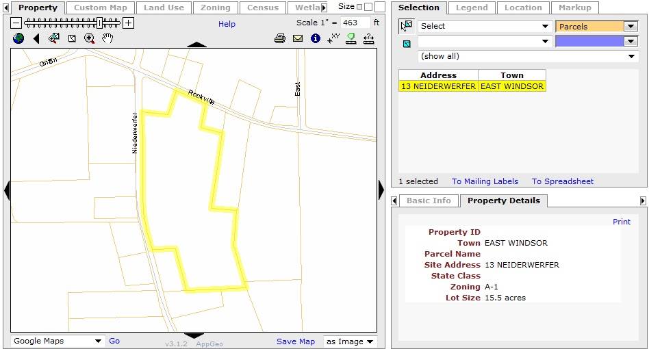
The 15.5 acres property, Map Number - 42 84 002, is an elongated plot located towards the east of Neiderwerfer Road and south of Rockville Road. The property is situated in a predominantly residential area of rural character. Residential plots can be seen towards the north, east, south and the west of the plot, across Neiderwerfer Road, while dense woodland covers the area towards the southeast.
The barn complex is located towards the western edge of the property abutting to Neiderwerfer Road. The ridge line of the main gambrel-roof barn runs north-south, almost parallel to the road. A 1 ½-story hip-roof barn can be seen towards the south of the complex while a large gable-roof barn with a shed-roof addition on its north eave-side can be seen towards southeast. The ridge lines of both the barns run east-west, parallel to each other but perpendicular to the road. The circa 1956 main residence is located towards further south of the main barn complex with its ridge line running north-south parallel to the road. Numerous sheds and other out-buildings can be seen scattered towards the east and southeast of the main residence. The property has parcels of fenced pasture land towards the north, east and south of the building complex with dense woodland demarcating its eastern edge.
- Typology & Materials
-
Building Typology
Materials
Structural System
Roof materials
Roof type
Approximate Dimensions
n/a
- Source
-
Date Compiled
02/25/2011
Compiled By
T. Levine and M. Patnaik, reviewed by CT Trust
Sources
Field notes and photographs provided by: John E. Harmon.
Assessors’ records retrieved on February 25th, 2011 from website http://www.equalitycama.com/
GIS information retrieved on February 25th, 2011from website http://www.crcog.org/gissearch/
Photograph/Information retrieved on February 25th, 2011 from website http://www.google.com
Information retrieved on February 25th, 2011 from website http://www.zillow.com
Sexton, James, PhD; Survey Narrative of the Connecticut Barn, Connecticut Trust for Historic Preservation, Hamden, CT, 2005, http://www.connecticutbarns.org/history
Visser, Thomas D.,Field Guide to New England Barns and Farm Buildings, University Press of New England, 1997.
- PhotosClick on image to view full file
-