Barn Record Bloomfield
RETURN TO ‘FIND BARNS’- Building Name (Common)
- Penwood State Park Maintenance Barn
- Building Name (Historic)
- Curtis and Louise Veeder Estate
- Address
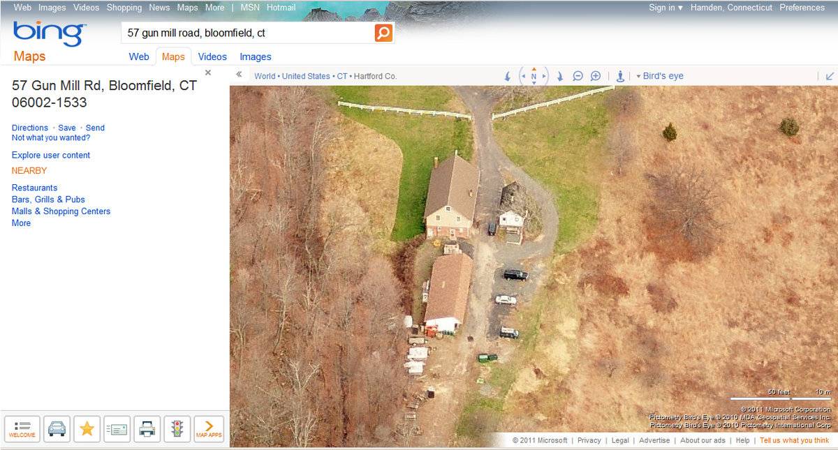
- 57 Gun Mill Road, Bloomfield
- Typology

- Overview
-
Designations
Historic Significance
Architectural description:
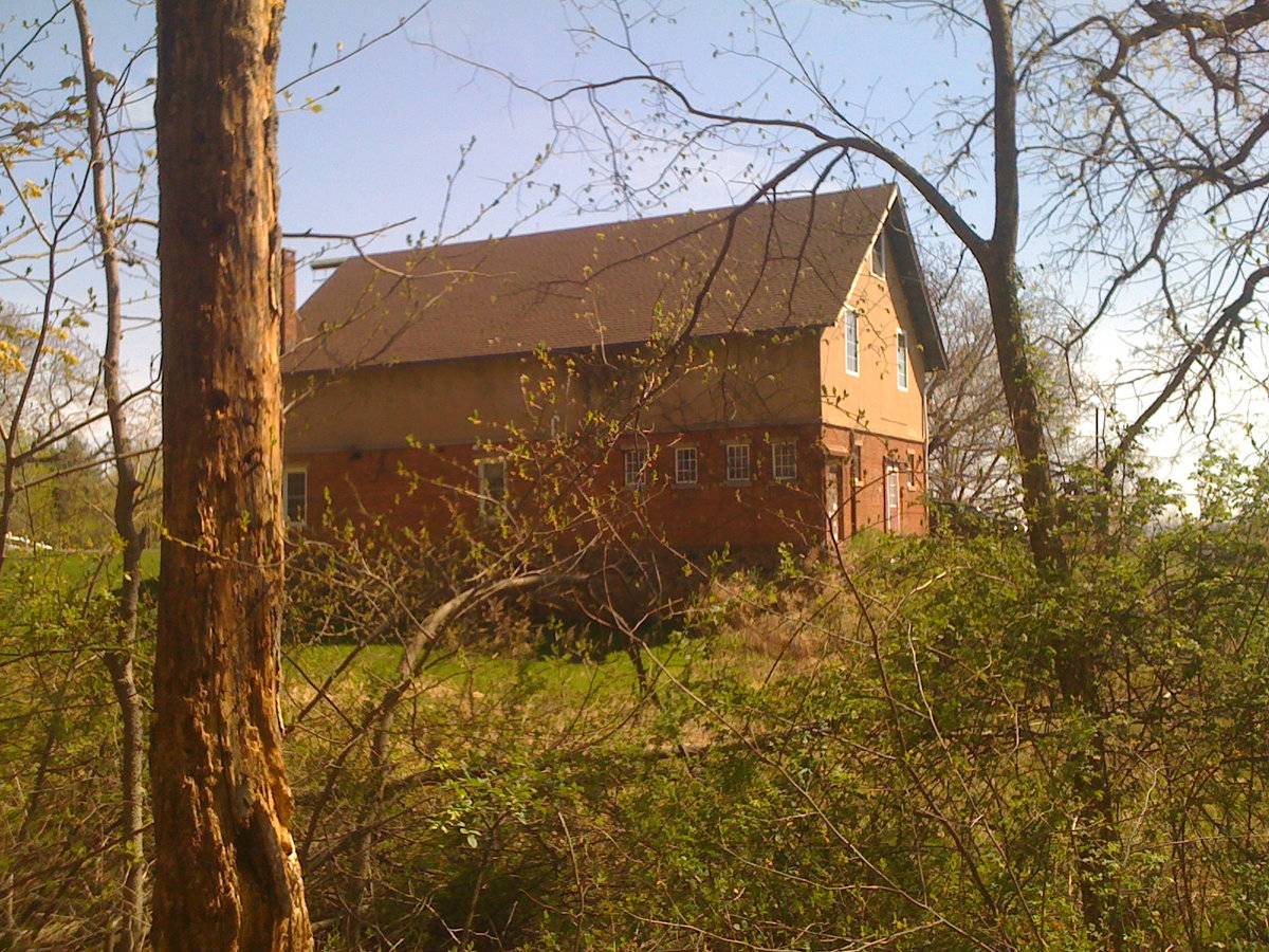
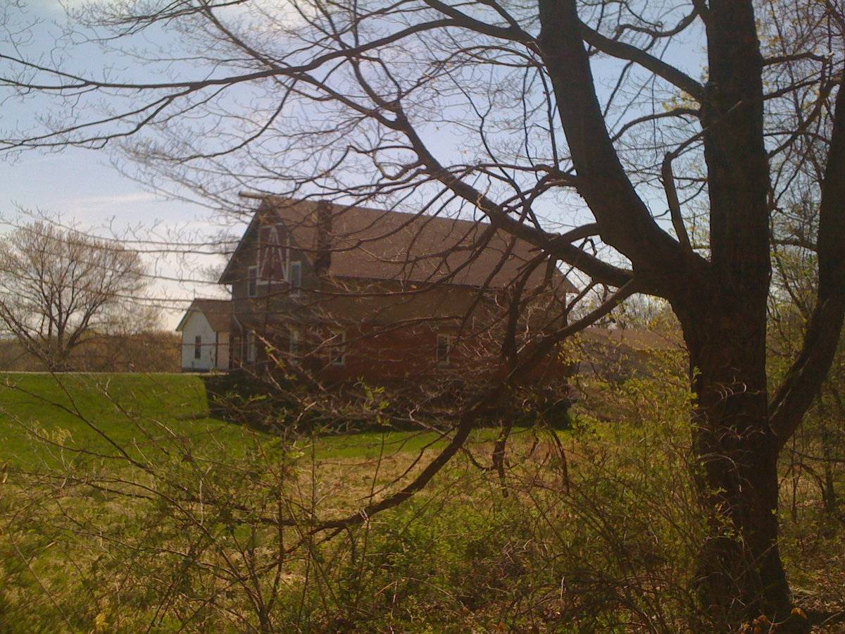
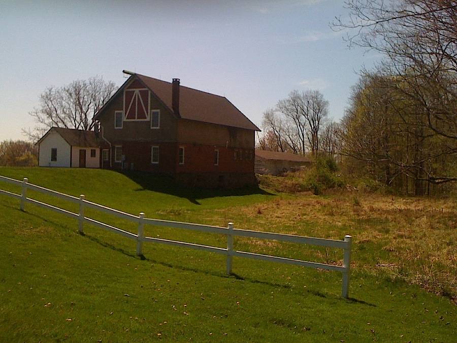
This is a 2 1/2-story eave-entry barn with a gable roof. The ridge-line runs north-south. The barn is set on a hillock, its grade declining from east to west, revealing a mortared stone foundation. Set on grade, the main west eave-façade has the main entry. Centered on the north half of the west eave-façade is a full-length half-glass door on the first floor. The glass half has a set of two evenly spaced multi-pane windows across the top of the door. The door is flanked by two multi-paned windows with trim on the first floor. The first window is next to the barn’s northwest corner while the second is on the center of the main west eave-façade. The south half of the west eave-façade has four evenly spaced four-pane windows with trim. The second floor appears to have a hayloft door centered over the main entry. The north gable-end of the barn is on grade until it declines sharply at the barn’s northeast corner. The north gable-end first floor has a half glass, side-swinging pass-through door on the barn’s northeast corner. West of the pass-through door and on the first floor are two symmetrically spaced twelve-pane windows with trim, lintels, and sills. The north gable-end second story and gable attic have a large centered hayloft door flanked by two symmetrically spaced six-over-six double-hung windows with trim. The apex of the north gable attic has what appears to be a projecting ridge beam. The east eave-side of the barn is several feet above grade. The east eave-side first floor has a centered six-over-six pane double-hung window with trim and a second six-over-six pane double-hung window with trim near the barn’s northeast corner. On the first floor, the south half of the east eave-side has four unevenly spaced nine-pane windows offset towards the barn’s northwest corner. All east eave-side windows have lintels and sills. The south gable-end first floor has a half-glass pass-through door that is offset east of center, flanked by two symmetrically placed windows with lintels and sills. West of the door and flanking windows is a hooded half-glass pass-through door near the barn’s southwest corner on the first floor. The south gable-end second floor and attic has two evenly spaced multi-paned windows, with a third window near the apex. All south gable-end windows are multi-paned and have trim.
The first floor barn walls are brick, while the second floor and gable attic walls are painted yellow and may be made of wood. The roof has boxed projecting eaves, is covered with shingles, and has a square brick chimney projecting from inside the barn’s northeast corner.
Historical significance:The oldest barns still found in the state are called the “English Barn,” “side-entry barn,” “eave entry,” or a 30 x 40. They are simple buildings with rectangular plan, pitched gable roof, and a door or doors located on one or both of the eave sides of the building based on the grain warehouses of the English colonists’ homeland. The name “30 by 40” originates from its size (in feet), which was large enough for 1 family and could service about 100 acres. The multi-purpose use of the English barn is reflected by the building’s construction in three distinct bays - one for each use. The middle bay was used for threshing, which is separating the seed from the stalk in wheat and oat by beating the stalks with a flail. The flanking bays would be for animals and hay storage.
The 19th century saw the introduction of a basement under the barn to allow for the easy collection and storage of a winter’s worth of manure from the animals sheltered within the building. The bank barn is characterized by the location of its main floor above grade, either through building into a hillside or by raising the building on a foundation. This innovation, aided by the introduction of windows for light and ventilation, would eventually be joined by the introduction of space to shelter more animals under the main floor of the barn.
The 19th century saw the introduction of the Gentleman’s barn. While many farmers were striving for efficiency to compete with farms in the middle of the country, a new type of farmstead appeared in Connecticut: the gentleman’s farm. These barns were frequently designed by famous architects and were part of giant complexes that combined the luxury of a weekend retreat with the grit of a working farm.
Historical background:A long wooded ridge dominates the sunset-side of the Connecticut River Valley in the vicinity of Hartford. Crested atop the northerly portion of the Talcott Mountain Range lies a sizable portion of the public domain, Penwood State Park. With this gift in 1944 to the citizens of Connecticut of nearly 800 acres, Curtis H. Veeder wished only that his beloved hilltop, “be kept in a natural state so that those who love nature may enjoy this property as I have enjoyed it.” Veeder was an industrialist, inventor and outdoorsman. Early maps of Penwood evidence Veeder’s engineering skill and demand for precise accuracy. Surveying, often after dark, he used a complex theodolite instrument and a flashlight to establish a true meridian line from the exact position of a star. Ardent hikers, Veeder and his wife, Louise, built many trails from which to more intimately observe the wildlife, woodland phenomena and scenic vistas surrounding the mountain. Appropriately, a section of Connecticut’s Blue Blazed Trail system, the Metacomet, now traverses much of Penwood.
Field Notes
Former estate converted to state park with picnic area, hiking trails. Barn appears to be park maintenance facility. http://www.ct.gov/dEP/cwp/view.asp?A=2716&Q=325248#history A long wooded ridge dominates the sunset-side of the Connecticut River Valley in the vicinity of Hartford. Crested atop the northerly portion of the Talcott Mountain Range lies a sizable portion of the public domain, Penwood State Park. With this gift in 1944 to the citizens of Connecticut of nearly 800 acres, Curtis H. Veeder wished only that his beloved hilltop, "be kept in a natural state so that those who love nature may enjoy this property as I have enjoyed it." Veeder was an industrialist, inventor and outdoorsman. Early maps of Penwood evidence Veeder's engineering skill and demand for precise accuracy. Surveying, often after dark, he used a complex theodolite instrument and a flashlight to establish a true meridian line from the exact position of a star. Ardent hikers, Veeder and his wife, Louise, built many trails from which to more intimately observe the wildlife, woodland phenomena and scenic vistas surrounding the mountain. Appropriately, a section of Connecticut's Blue Blazed Trail system, the Metacomet, now traverses much of Penwood. Barn position: 41.854379,-72.776098 Former estate converted to state park with picnic area, hiking trails. The Veeders' Hartford mansion at 1 Elizabeth Street is now the home of the Connecticut Historical Society, and a contributing resource in the Prospect Avenue Historic District. Penwood was a country property and may not have had a principal dwelling other than a cabin on the ridge-top (interview with Kate Steinway, Executive Director, CHS, 4/06/2012).
- Use & Accessibility
- Environment
Related features
Environment features
Relationship to surroundings
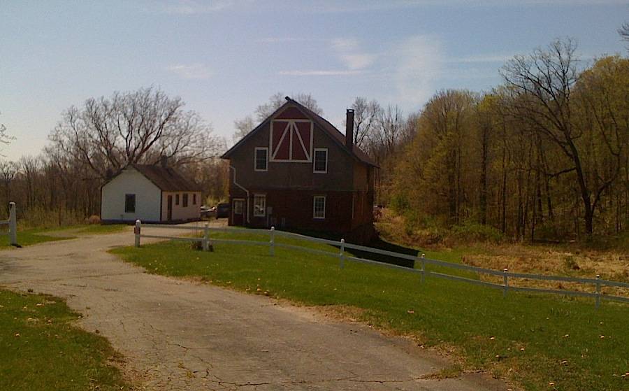
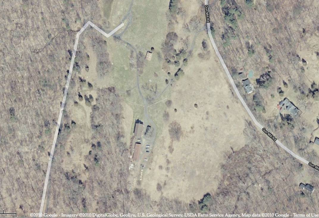
Barn I is behind and to the west of a small cabin or shed, apparently used as an office, at the east edge of Penwood State Park accessible from Gun Mill Road. A long five-bay Wagon Shed II is south of the barn and has its east eave-side open. The south lawn has several picnic tables. A driveway starts from the barn and curves north into Gun Mill Road. Woodland surrounds the house and lawn.
A driveway starts from Gun Mill Road and S-curves in a southeastern direction into a roundabout and parking area for the barn, office, and extended shed. The office is in the center of the roundabout and east of the barn. The office ridge line is parallel to the barn ridge line. Southeast of the barn and south of the office is the parking lot. Garage/wagon shed II is south of the barn and southwest of the office. The Shed II ridge line is parallel to the barn ridge line. A lawn extends west of the barn to woodland and north of the barn to a white picket fence that marks the border between the three buildings and picnic grounds. The barn lawn curls south in between the roundabout in the south and open land northeast and east of the barn, office and garage II. The open land has Gun Mill Road on its northern border and house woodland on its eastern border. The picnic grounds has scattered picnic tables, bathroom and other scattered buildings. Woodland surrounds the picnic grounds.
The house and barn are on the east edge of Penwood State Park, which is about 800 acres of picnic areas, woodland, and nature trails in the Talcott Mountain Range. Outside of Penwood State Park is residential, rural, and woodland.
- Typology & Materials
-
Building Typology
Materials
Structural System
Roof materials
Roof type
Approximate Dimensions
n/a
- Source
-
Date Compiled
03/20/2011
Compiled By
J. Toner & T. Levine, reviewed by CT Trust
Sources
List of State-owned properties on the State Register, SHPO files, Stacey Vairo 4/16/2012.
Aerial Mapping:
http://www.bing.com/maps accessed 3/20/2011.CT DEP - http://www.ct.gov/dEP/cwp/view.asp?A=2716&Q=325248#history
CT Penwood State Park Map: http://www.ct.gov/dep/cwp/view.asp?A=2716&Q=325248#map
Field notes and photographs by Charlotte Hitchcock on 4/17/2010.
Andrews, Gregory, & Ransom, David F., Prospect Avenue National Register District Nomination No. 85001918, National Park Service, 1985 (for Veeder House, 1 Elizabeth St., Hartford CT).
McAlester, Virginia and Lee. A Field Guide to American Houses, Alfred A. Knopf, 1984.
Sexton, James, PhD, Survey Narrative of the Connecticut Barn, Connecticut Trust for Historic Preservation, Hamden, CT, 2005, http://www.connecticutbarns.org/history.
Visser, Thomas D., Field Guide to New England Barns and Farm Buildings, University Press of New England, 1997.
- PhotosClick on image to view full file
-