Barn Record Guilford
RETURN TO ‘FIND BARNS’- Building Name (Common)
- Scranton Farm (Part 1 of 2)
- Building Name (Historic)
- Willard Reuben Scranton
- Address
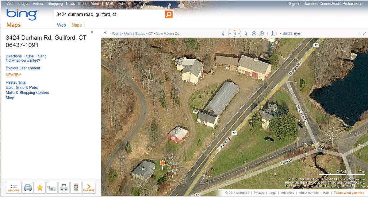
- 3424 Durham Road (Route 77), Guilford
- Typology

- Overview
-
Designations
n/a
Historic Significance
Architectural description:
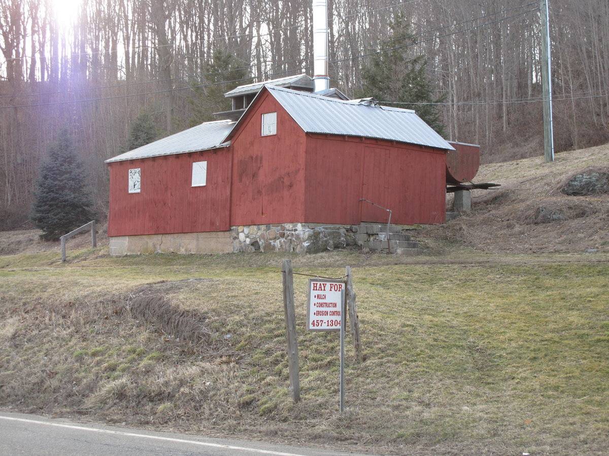
This is a 1 ½-story eave-entry barn with a gable-roof addition on its northeast gable-end and a small shed-roof addition on its southwest gable-end. The main facade faces northeast in the eave-side of the addition. The ridge-line of the original section runs northwest-southeast, which is parallel to Durham Road at this point. The ridge-line of the main barn is perpendicular to that of the addition and is wider than the main barn; the southeast eave-side of the addition is flush with the southeast gable-end of the main barn, but the northwest eave-side of the addition extends beyond the northwest gable-end of the main barn. The main entrance is a single pass-through door centered on the northeast eave-side of the gable-roof addition. Concrete steps lead up to the entrance. The southeast gable-end of the gable-roof addition has a six-pane window in the gable attic. The grade is lower at the southeast corner and there is an exposed field-stone foundation at that end. The southeast eave-side of the main barn has two evenly-spaced six-pane windows. There is an exposed concrete block foundation on this end of the barn due to the change in grade. The southwest gable-end of the barn has a small one-story shed-roof projection centered on it. The projection is flanked by six-pane windows. Centered on the ridge-line of the barn is a long ventilator. On the northwest gable-end of the gable-roof addition is equipment for the maple syrup production. Both sections of the sugar house have vertical flush-boards painted red with white trim around the windows. The roofs, which are covered in tin, have a slight projecting overhang and have exposed rafter tails on the eave sides. The foundation is mortarted fieldstone on the original section and the addition has a concrete block foundation.
Historical significance:The oldest barns still found in the state are called the “English Barn,” “side-entry barn,” “eave entry,” or a 30 x 40. They are simple buildings with rectangular plan, pitched gable roof, and a door or doors located on one or both of the eave sides of the building based on the grain warehouses of the English colonists’ homeland. The name “30 by 40” originates from its size (in feet), which was large enough for 1 family and could service about 100 acres. The multi-purpose use of the English barn is reflected by the building’s construction in three distinct bays - one for each use. The middle bay was used for threshing, which is separating the seed from the stalk in wheat and oat by beating the stalks with a flail. The flanking bays would be for animals and hay storage.
Before the mid-1800s most maple syrup was boiled in large iron caldrons outdoors near the maple grove, or “sugar bush.” Between the 1850s and 1870s, however, the maple sugar house became a common sight on farms in the maple-forested areas of New England, especially as sugarers adopted large metal pans. These pans are supported over the fire by an “arch,” typically constructed of hard bricks and mortar on a stone base. Iron fire doors are usually fitted at the end of the arch nearest the woodshed.
The maple sugar house is typically a single-story, gable-roofed building with a large gable-roofed vent on the roof. There is usually a chimney or large steel flue pipe at one end, a door on the side, and a few small windows. A large evaporator pan over a brick-walled firebox arch fills the dirt-floored interior. Often an open woodshed, which also serves as a storage shed for pails and other equipment, is attached to one gable end.
Currently used as a sugar house for maple syrup production, but part of the structure was originally an ice house. “The use of ice for refrigeration became popular in New England by the middle of the 19th century, especially as farmers shifted to dairy production. The small farm buildings used to store ice through the summer can usually be recognized by their thick insulated walls and few windows. Early examples have low ventilators on the roof. Ice was packed in straw or the walls were built double with an air space of up to 18 inches, as insulation. Icehouses continued to be used until electrical refrigeration was installed during the 1930s and 1940s.”
Field Notes
Sugar house is open to the public in early spring; Environment: active agriculture, open land, residential, rural Materials: concrete and fieldstone foundation, vertical siding, tin, gable roof Part of the sugar house was an ice house once located on Lake Quonnipaug across from the Chittenden Farm Sources: Oliver L. Scranton, Jr., Town of Guilford Assessment Database
- Use & Accessibility
Use (Historic)
Use (Present)
Exterior Visible from Public Road?
Yes
Demolished
n/a
Location Integrity
Moved
- Environment
Related features
Environment features
Relationship to surroundings
The sugar house is part of an active farm. The sugar house was originally located at another site on Lake Quonnipaug across from the Chittenden Farm, where it served as an ice house. Southwest of the sugar house is a c. 1945 house, whose ridge-line runs perpendicular to the ridge-line of the original section of the sugar house. Northeast of the sugar house is a bank barn with a gambrel roof with a small one-story house attached to its northeast eave-side. Immediately northeast of this is a greenhouse. Northwest of the greenhouse is a two-story bank barn whose ridge-line runs perpendicular to that of the original section of the sugar house. Northeast of the greenhouse is a large two-story English barn with a ridge-line that runs parallel to that of the original section of he sugar house. Located adjacent to the northwest gable-end of the English barn is a one-story open-side shed with a gable roof. The total size of the site is 62.87 acres, extending far northwest from the site’s buildings, which are located along Durham Road. The surrounding area is rural residential, open land, and woodland.
Parcel ID: 11401901.
- Typology & Materials
-
Building Typology
Materials
Structural System
Roof materials
Roof type
Approximate Dimensions
Approximately 625 sq. ft.
- Source
-
Date Compiled
02/25/2011
Compiled By
B. Bjorklund & T. Levine, reviewed by CT Trust
Sources
Field notes and photographs by Penny Colby, 06/29/2010
Town of Guilford Assessor’s Record or GIS Viewer: http://www.guilfordgis.com/detail.asp?parid=114019
Parcel ID: 11401901Aerial Mapping:
http://maps.google.com accessed 02/25/2011
http://www.bing.com/maps accessed 02/25/2011http://www.workingtheland.com/links_maple_nh.htm
Sexton, James, PhD, Survey Narrative of the Connecticut Barn, Connecticut Trust for Historic Preservation, Hamden, CT, 2005, http://www.connecticutbarns.org/history.
Visser, Thomas D., Field Guide to New England Barns and Farm Buildings (Hanover: University Press of New England, 1997), 61, 113-115.
- PhotosClick on image to view full file
-