Barn Record Durham
RETURN TO ‘FIND BARNS’- Building Name (Common)
- n/a
- Building Name (Historic)
- n/a
- Address
- 500 New Haven Road ( Rte 17 ), Durham
- Typology
- Overview
-
Designations
n/a
Historic Significance
Architectural description:
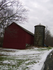
This is a 1 ½ - story eave-entry bank barn with a salt-box roof addition on its west eave-side and the bank along its east eave-side. The north gable-side of the barn faces New Haven Road at an angle while the west eave-side faces Shady Lane. The ridge line of the barn runs north- south almost parallel to Shady Lane. The main façade of the barn is the west eave-side with the main entrance off-centered towards the south. The salt-box roof addition covers almost half the length of the façade from the north. The grade level along the façade gradually drops towards the north revealing the cement plastered masonry of the bank level, lined with series of square windows. The north gable-side of the barn is devoid of any significant feature apart from two distinct siding divide lines separating the gable attic, the first floor level and the bank level. The gable-roof of the barn is mounted by two equally space metal ventilators.
The wooden frame of barn is supported on cement plastered masonry foundation. The barn has asphalt shingle roofing and red painted vertical siding on walls.
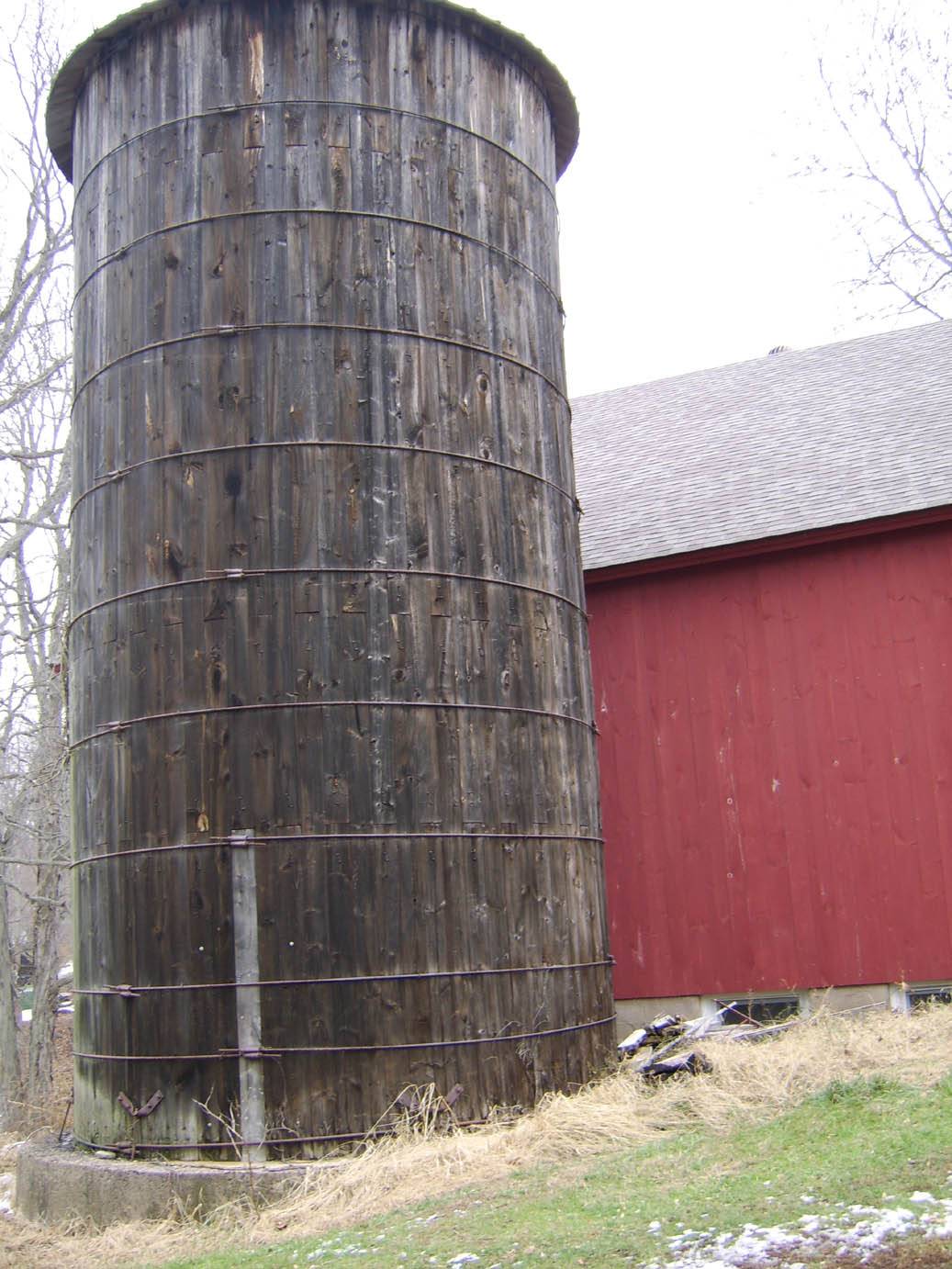
A cylindrical silo supported on a circular concrete base can be seen at the center of the salt-box roof addition on the west eave-façade of the barn. The concrete silo is mounted by a conical metal roof.
Historical significance:The oldest barns still found in the state are called the “English Barn,” “side-entry barn,” “eave entry,” or a 30 x 40. They are simple buildings with rectangular plan, pitched gable roof, and a door or doors located on one or both of the eave sides of the building based on the grain warehouses of the English colonists’ homeland. The name “30 by 40” originates from its size (in feet), which was large enough for 1 family and could service about 100 acres. The multi-purpose use of the English barn is reflected by the building’s construction in three distinct bays - one for each use. The middle bay was used for threshing, which is separating the seed from the stalk in wheat and oat by beating the stalks with a flail. The flanking bays would be for animals and hay storage.
The 19th century saw the introduction of a basement under the barn to allow for the easy collection and storage of a winter’s worth of manure from the animals sheltered within the building. The bank barn is characterized by the location of its main floor above grade, either through building into a hillside or by raising the building on a foundation. This innovation, aided by the introduction of windows for light and ventilation, would eventually be joined by the introduction of space to shelter more animals under the main floor of the barn.Cement silos were sometimes poured in place in one piece, but the more common practice was to pour large interlocking rings that were then stacked. As with wooden stave silos, the structures are held together with adjustable steel hoops, spaced about fifteen inches apart. Since concrete does not expand and contract with changes in moisture levels, the hoops on concrete stave silos were usually tightened only once after the structure was built. Inside, these silos are coated with a cement wash.
Field Notes
500 New Haven Road (Rte 17). Carol Ann Brauer and Joyce Kellish, 1935 w/ Butler Silo (also 1935).
- Use & Accessibility
Use (Historic)
Use (Present)
Exterior Visible from Public Road?
Yes
Demolished
n/a
Location Integrity
Unknown
- Environment
Related features
Environment features
Relationship to surroundings
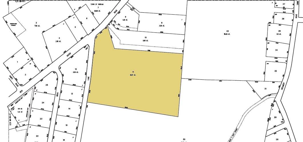
The 13.97 acres property, parcel number - P0183600 and map number 100, is a corner plot towards the south of New Haven Road, Route 17, and the east of Shady Lane. The plot has a narrow frontage to New Haven Road but spreads out towards the south and the south-east allowing Shady Lane to form its western edge. The property is situated in a mixed land-use area with residential plots towards the west and parcels of farm land with active agriculture towards the south. The area towards the east is covered by dense woodland while Chapman Manufacturing is located towards the north, across New Haven Road.
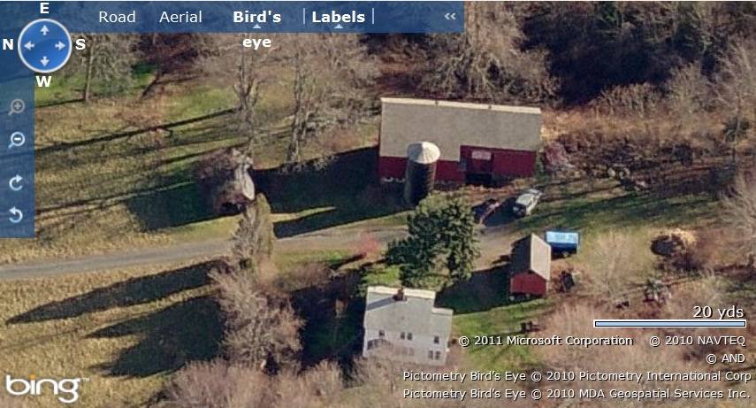
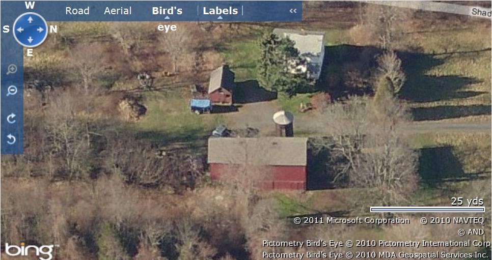
The barn is located in the south-western corner of the property, offset from Shady Lane. The circa 1931 old style main residence is positioned towards the west of the barn, nearer to Shady Lane. The property is accessed by a driveway from New Haven Road which forms a cul-de-sac, separating the barn and the main residence. A cylindrical silo mounted by a conical roof is located immediately towards the west of the barn while another small 1 – story gable roof barn can be seen towards the south-west. The ridge lines of the main barn and the main residence run north-south parallel to Shady Lane while that of the second barn runs east-west. A 1-story gable-roof gable-entry garage with its ridge line running east-west is located towards the north of the main barn. Open land can be seen towards the northern edge and towards the south-east of the property while dense woodland surrounds the building complex in the south-western corner.
- Typology & Materials
-
Building Typology
Materials
Structural System
Roof materials
Roof type
Approximate Dimensions
Barn: 900 SqFt, Circa 1935 Barn: 768 SqFt, Circa 1935 Garage: 336 SqFt, Circa 1930 Silo: 288 SqFt, Circa 1935
- Source
-
Date Compiled
09/21/2006
Compiled By
T. Levine and M. Patnaik, reviewed by CT Trust
Sources
Field-notes provided by – Jim McLaughlin
Assessors’ records retrieved on January 27th, 2011 from website http://durham.univers-clt.com
Map and property records retrieved on January 27th, 2011 from website http://www.townofdurhamct.org
Photograph/Information retrieved on January 27th, 2011 from website http://www.google.com
Photographs/Information retrieved on January 27th, 2011 from website http://www.zillow.com
Sexton, James, PhD; Survey Narrative of the Connecticut Barn, Connecticut Trust for Historic Preservation, Hamden, CT, 2005, http://www.connecticutbarns.org/history
Visser, Thomas D.,Field Guide to New England Barns and Farm Buildings, University Press of New England, 1997.
- PhotosClick on image to view full file
-