Barn Record Guilford
RETURN TO ‘FIND BARNS’- Building Name (Common)
- William L. Dudley House
- Building Name (Historic)
- William L. Dudley House
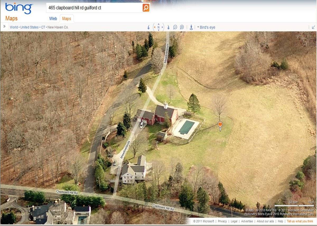
- Address
- 465 Clapboard Hill Road, Guilford
- Typology
- Overview
-
Designations
Historic Significance
Architectural description:
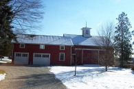
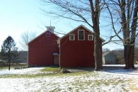
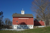
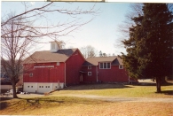
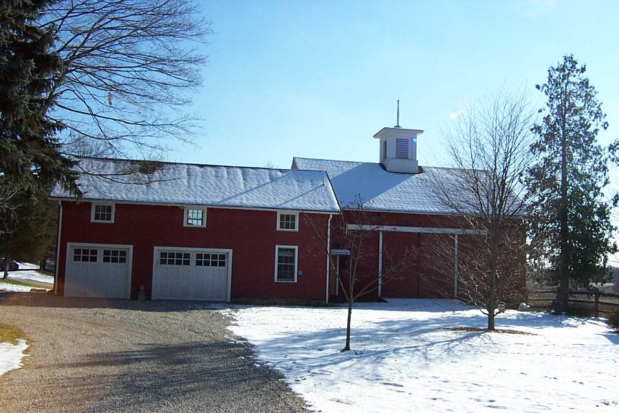
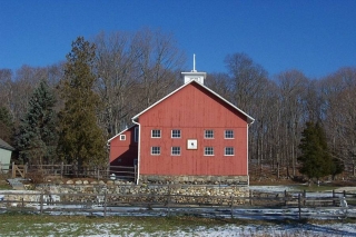
This is a 1 1/2-story eave-entry bank barn with an attached gable-roof garage. The main facade faces northwest and the ridge-line of the barn is parallel to this portion of Clapboard Hill Road, which runs approximately southeast-northwest. The main entry is a hooded pair of double-height exterior sliding wood doors located in the center of the northwest eave-side. There appears to be a pass-through door with a shed-roof hood to the north of the main entry. The grade of the southwest gable-end of the barn declines sharply, revealing a feildstone foundation. The grade declines further at the southwest eave-side of the barn, revealing a basement level. The southwest gable-end has two rows of four, six-pane, fixed-sash, wood windows. The southeast eave-side of the barn appears to have three overhead garage doors in the basement level. The garage doors in the first and third bays of the side each have two, four-pane, fixed-sash windows; the garage door in the center bay has four, four-pane, fixed-sash windows. The first floor has a hooded pair of double-height exterior sliding wood doors in the center and a pair of hinged, pass-through doors towards the south corner. The first floor also has a six-pane, fixed-sash wood window, located between the sliding doors and the pass-through doors. Another six-pane, fixed-sash wood window is located just beneath the eave, in the east half of the southeast eave-side of the barn. The grade at the northeast gable-end of the barn inclines sharply to the main level. The northeast gable-end of the barn has a pass-through door with a shed-roof hood in the north half of the first floor. A six-pane, fixed-sash, wood window is located in the gable attic. The barn has vertical siding painted red with white trim and cornice boards. The foundation is field-stone. The roof is covered with asphalt shingles and a cupola is centered atop the ridge-line. The cupola has a louvered vent in each side, a hipped roof and is topped with a wood finial.
A 1 1/2-story, gable-roof garage extends off the north corner of the barn. The main facade faces northwest and the ridge-line of the garage is parallel to the ridge-line of the barn. The northwest eave-side of the garage has pairs of what appear to be hinged, wood garage doors in its northernmost and middle bay. A six-over-six, double-hung window is located in the west half of the first floor of the northwest eave-side of the garage. Three six-pane, fixed-sash, wood windows are distributed evenly across the northwest eave-side of the garage, just below the eave line. The northeast gable-end of the garage is blank at the first floor. In the gable attic are three windows: a six-over-six, double-hung window in the gable peak, flanked by four-pane, fixed-sash windows. The southeast eave-side of the garage is blank at the first floor except for what appears to be a fixed-sash window in its south half. There appears to be another fixed-sash window just above it, just beneath the eave. A set of three six-over-six, double-hung windows are centered in the second story, within a shed-roof dormer. A single six-pane, fixed-sash window is located in the east half of the southeast eave-side of the garage. The southwest gable-end of the garage is only partly visible. At the first floor, there appears to be a window in the center. In the attic level, there is a four-pane, fixed-sash window in the south half and what appears to be a double-hung window in the center. The garage has vertical siding painted red with white trim and cornice boards. The foundation is not visible. The roof is covered with asphalt shingles.
Historical significance:The oldest barns still found in the state are called the “English Barn,” “side-entry barn,” “eave entry,” or a 30 x 40. They are simple buildings with rectangular plan, pitched gable roof, and a door or doors located on one or both of the eave sides of the building based on the grain warehouses of the English colonists’ homeland. The name “30 by 40” originates from its size (in feet), which was large enough for 1 family and could service about 100 acres. The multi-purpose use of the English barn is reflected by the building’s construction in three distinct bays - one for each use. The middle bay was used for threshing, which is separating the seed from the stalk in wheat and oat by beating the stalks with a flail. The flanking bays would be for animals and hay storage. The 19th century saw the introduction of a basement under the barn to allow for the easy collection and storage of a winter’s worth of manure from the animals sheltered within the building. The bank barn is characterized by the location of its main floor above grade, either through building into a hillside or by raising the building on a foundation. This innovation, aided by the introduction of windows for light and ventilation, would eventually be joined by the introduction of space to shelter more animals under the main floor of the barn.
Historical background:The William L. Dudley House and associated barn are contributing properties in the Dudleytown Historic District. The district contains residential properties built as farmhouses in the 18th and 19th centuries by descendants of William Dudley, who came to Guilford from England in 1639. The spine of the district is Clapboard Hill Road, which runs through the district for 1.4 miles.
(Brown and Wigren)
Field Notes
Located in Dudleytown National Register Historic District, and appears to be a contributing resource within the district.
- Use & Accessibility
Use (Historic)
Use (Present)
Exterior Visible from Public Road?
Yes
Demolished
n/a
Location Integrity
Unknown
- Environment
Related features
Environment features
Relationship to surroundings
The site is located at the southeast corner of the intersection of Clapboard Hill Road and Meadowlands. The barn is to the east and behind the c1841 house with which it is associated. The ridge-line of the main block of the house is perpendicular to the ridge-line of the barn. An in-ground pool and patio is located immediately to the southwest of the barn. There is a small gable-roof building, possibly a pool house, located to the northwest of the pool. The buildings are clustered in the northwest quadrant of the site. The site is accessed by two driveways off Meadowlands; one leads to the garage and to a parking area near the house, while the other leads to the southeast side of the barn. The total size of the site is 4.69 acres. The East River is located a short distance to the west, just across Clapboard Hill Road. The area surrounding the site is residential, open land and woodland.
Map 081037
- Typology & Materials
-
Building Typology
Materials
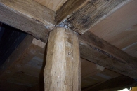
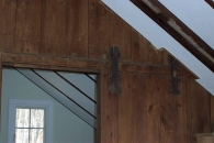
Structural System
Roof materials
Roof type
Approximate Dimensions
1200 sq. ft.
- Source
-
Date Compiled
02/20/2011
Compiled By
J. M. Doherty & T. Levine; reviewed by CT Trust
Sources
Field notes and photographs by Jane Montanaro - 09/21/2006 and Nona Bloomer - 7/6/2010.
Town of Guilford Assessor’s Record http://www.equalitycama.com/default.html
Town of Guilford Geographic Information System
http://www.guilfordgis.com/Map 081037
Aerial Mapping:
http://www.bing.com/maps accessed 02/20/2011.Brown, Elizabeth Mills and Christopher Wigren, Dudleytown National Register District Nomination No. 91000951, National Park Service, 1991.
Sexton, James, PhD, Survey Narrative of the Connecticut Barn, Connecticut Trust for Historic Preservation, Hamden, CT, 2005, http://www.connecticutbarns.org/history.
Visser, Thomas D., Field Guide to New England Barns and Farm Buildings, University Press of New England, 1997.
- PhotosClick on image to view full file
-