Barn Record Durham
RETURN TO ‘FIND BARNS’- Building Name (Common)
- n/a
- Building Name (Historic)
- n/a
- Address
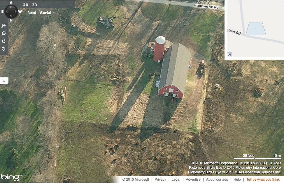
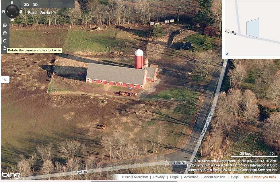
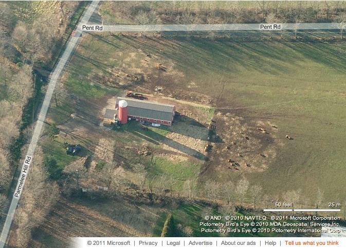
- 337 Parmelee Hill Road, Durham
- Typology
- Overview
-
Designations
n/a
Historic Significance
Architectural description:
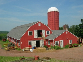
This is a 2 ½ - story gable-entry dutch-gambrel roof barn with a gable-roof addition intersecting its south-eastern corner and a silo towards its east. The south gable-side of the main barn faces Parmelee Hill Road while the west eave-side faces Pent Road. The ridge line of both the main barn and the gable-roof addition run north-south, almost perpendicular to Parmelee Hill Road. The main façade of the barn is the south gable-façade with the main entrance at the center through a pair of exterior-hung double X-braced wagon doors. A nine-pane square awning window can be seen towards the west of the main entrance while the area towards the east is covered by the intersecting gable-roof addition. The gable-attic above is lined by cornice board and has a pair of exterior-hung X-braced sliding hay doors at the center flanked by two similar nine-pane square awning windows. The main south gable-façade of the barn has returning eaves with a louvered vent just below the apex of the roof. The west eave-side of the barn has nine equally spaced nine-pane square awning windows. A pass-through door can be seen on the west eave-side towards the south of the first nine-pane awning window from the north. The north gable-side of the barn has similar arrangement of openings as the main south gable-façade. The east eave-side of the barn has the gable-roof addition intersecting its south-east corner followed by the silo. Six nine-pane square awning windows can be seen equally spaced towards the north of the gable-roof addition.
The south gable-side of the gable-roof addition has a nine-pane hinged paneled pass-through door off-centered towards the west. A nine-pane square awning window can be seen towards the west of the pass-through door while another double-hung sash window can be seen towards the east. The gable attic above is lined by cornice board and has a louvered vent just below the apex of the roof. The west eave-side of the gable-roof addition has a nine-pane square awning window at the center.
A cylindrical wooden silo mounted by a hemi-spherical roof and a steel water tank are located towards the north-east corner of the gable-roof addition.The wooden frames of both the barn and the gable-roof addition are supported on cement plastered masonry foundation. Both the barn and the gable-roof addition have red painted vertical siding walls with white corner boards and asphalt shingle roofing.
Historical significance:By the early 20th century agricultural engineers developed a new approach to dairy barn design: the ground-level stable barn, to reduce the spread of tuberculosis bacteria by improving ventilation, lighting, and reducing the airborne dust of manure. A concrete slab typically serves as the floor for the cow stables. Many farmers converted manure basements in older barns into ground-level stables with concrete floors. Some older barns were jacked up and set on new first stories to allow sufficient headroom. With the stables occupying the entire first story, the space above serves a a hayloft. By the 1920s most ground-level stable barns were being constructed with lightweight balloon frames using two-by-fours or two-by-sixes for most of the timbers. Novelty or tongue-and-groove beveled siding is common on the walls, although asbestos cement shingles also were a popular sheathing. Some barns have concrete for the first-story walls, either poured in place or built up out of blocks.
The gambrel roof design was universally accepted as it enclosed a much greater volume than a gable roof did, and its shape could be formed with trusses. Also see entry for Pole Barn.When chopped cornstalks are compressed to prevent their exposure to the air, the silage ferments instead of spoiling, providing nutritious food for the dairy herd and allowing them to produce milk through the winter. Early silos were built inside the barns, but by the 1890s free-standing silos were being built outside dairy barns. Constructed much like a very large wooden barrel, with adjustable steel hoops holding the vertical grooved staves together, the round wooden stave silo was widely accepted by dairy farmers in New England from the 1890s through the 1930s. Conical roofs are most common on wooden stave silos, usually covered with composition sheet roofing and topped with a metal ventilator. Removable wooden access doors extend up one side. The hoops were loosened in fall to accommodate the swelling of the wood as it absorbed moisture from the silage, and tightened over the winter as the silage dried.
Historical background:
Geographical constraints, as well as advantages, and a particularly heterogeneous settlement population drawn from all over the Connecticut Colony, were some of the factors that shaped the course of Durham’s history, transforming the town from a self-sufficient farming village into a relatively cosmopolitan center of commercial agriculture and small-scale, agrarian-based industry.Prior to settlement the Town of Durham was known as the Coginchaug, or Great Swamp. Most of the land in the town had been granted to individuals for distinguished service to the colony in military or civic affairs in the seventeenth century. All of these men were absentee owners; none were anxious to occupy what was then one of the least desirable areas for settlement in the colony. Swamp and marshland occupied most of the central part of the area, surrounded by rolling hills overlaying rocky ledges. Less than one third of the mere 15,000 acres was suitable for cultivation.
(Cunningham)
Field Notes
Street number is approximate - northeast corner of Pent Road and Parmelee Hill. Additional text written by Rachel Parris.
- Use & Accessibility
- Environment
Related features
Environment features
Relationship to surroundings
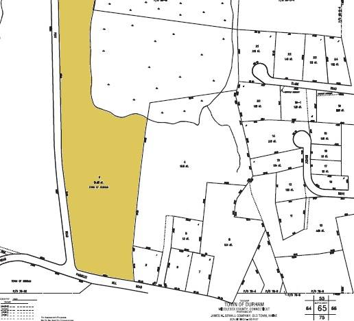
The 34.83 acres property, parcel number - D0081700 and map number 65, is a corner plot located towards the north of Parmelee Hill Road and the east of Pent Road. The elongated plot spreads towards the north with a relatively narrow frontage to Parmelee Hill Road. The property is situated in a predominantly residential area of rural character with residential plots towards the east and the south, across Parmelee Hill Road. Parcels of farmland with active agriculture can be seen towards the south-west and the west, across Pent Road. Dense woodland covers the area towards the east and the north-east of the elongated plot.
The barn is located in the south-eastern corner of the property with its ridge line running north-south, almost perpendicular to Parmelee Hill Road. The barn is accessed by a driveway from the south of the barn which encircles it and continues further north. The barn is surrounded by open land in all directions while dense woodland can be seen towards further north and north-east. The property also has a tract of open land towards its north-west, along Pent Road.
- Typology & Materials
-
Building Typology
Materials
Structural System
Roof materials
Roof type
Approximate Dimensions
Dairy/horse barn: 3800 SqFt, Circa 2004 Post/plank fence silo: Circa 2004 Shed: 120 SqFt, Circa 2006
- Source
-
Date Compiled
09/01/2010
Compiled By
T. Levine and M. Patnaik, reviewed by CT Trust
Sources
Photographs and field-notes provided by – Jim McLaughlin
Assessors’ records retrieved on February 4th, 2011 from website http://durham.univers-clt.com
Map and property records retrieved on February 4th, 2011 from website http://www.townofdurhamct.org
Photograph/Information retrieved on February 4th, 2011 from website http://www.google.com
Photographs/Information retrieved by Charlotte Hitchcock on September 1st, 2010 from website http://www.zillow.com
Cunningham, Jan, Main Street Historic District Nomination No. 86002837, National Park Service, 1986.
Sexton, James, PhD; Survey Narrative of the Connecticut Barn, Connecticut Trust for Historic Preservation, Hamden, CT, 2005, http://www.connecticutbarns.org/history
Visser, Thomas D.,Field Guide to New England Barns and Farm Buildings, University Press of New England, 1997.
- PhotosClick on image to view full file
-