Barn Record South Windsor
RETURN TO ‘FIND BARNS’- Building Name (Common)
- n/a
- Building Name (Historic)
- n/a
- Address
- 1299 Main Street, South Windsor
- Typology

- Overview
-
Designations
Historic Significance
Architectural description:
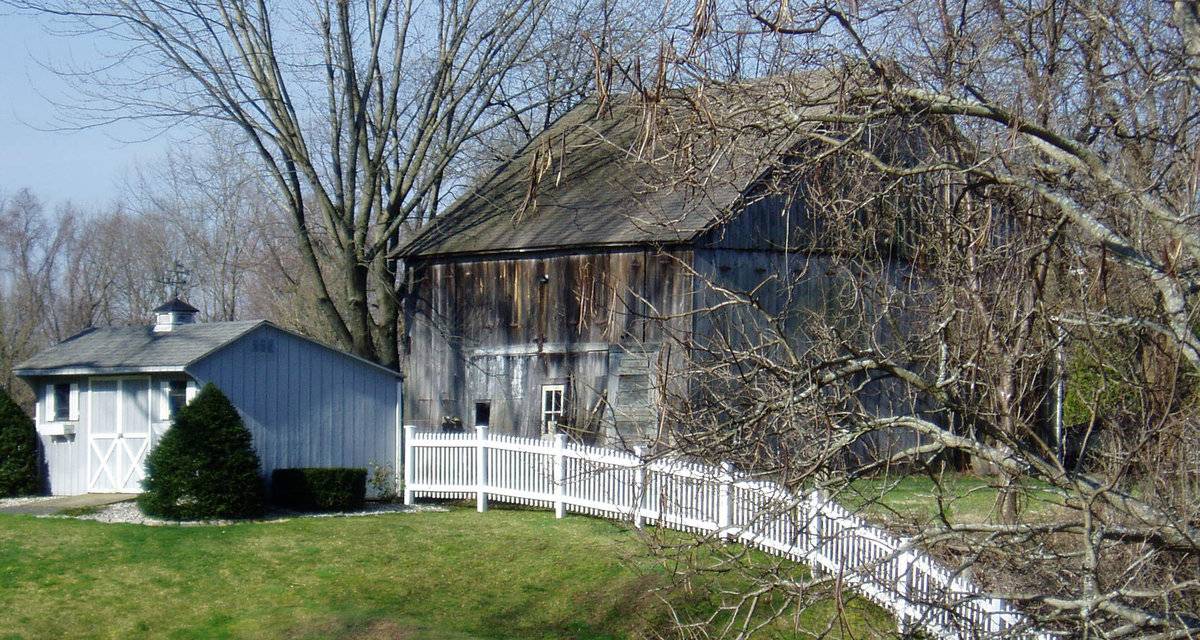
This is a 1 ½ - story gable-entry three-aisle tobacco shed which appears to be four-bent. The east eave-side of the shed faces Main Street while the ridge line runs north-south, parallel to this portion of the road. The south gable-end of the tobacco shed is the main façade with the main entrance at the center through a wagon door entrance. The east eave-side of the shed appears to have a wagon door entrance at the center originally which now has a window opening towards the south and a hinged pass-through with four-pane window insert towards the north. A second hinged pass-through door can be seen towards the north. The north gable-end of the shed has a distinct girt siding divide line separating the gable attic. The shed has a system of ventilation through the vertical siding on the east eave-side and the north gable-end in which alternate boards are hinged along the sides to open like tall narrow doors, each held in place by its own hook.
The wooden frame of the tobacco shed has asphalt shingles roofing and vertical siding walls.Historical significance:
The main residence associated with the tobacco shed is contributing to Windsor Farms Historic District, 86000723 NRIS.
The tobacco barn, or shed as it is called in the Connecticut River Valley, is one of the most distinctive of the single-crop barns. They tend to be long, low windowless buildings with pitched roofs. They are characterized by vented sides to regulate air flow and allow harvested tobacco to cure at the appropriate rate. Derived initially from the design of the English barn, the shed is composed of a fixed skeleton consisting of two- or three-aisle bents repeated at intervals of 15 feet to the desired length. The wood-framed bents sit on piers of stone or concrete and the bents are connected by girts and diagonal braces. Typically there are two doors at each end, making the shed a “drive-through,” although some sheds are accessed through doors on the sides. The interior structural framework serves a second purpose in addition to supporting the walls and roof of the building; it provides a framework for the rails used to hang the tobacco as it cures.
This is accomplished with one of four different systems (more than one method may be utilized in a single shed):
a) Vertical slats - siding in which every second board is hinged at the top and tilted out at the bottom by means of a horizontal cleat, that lifts several boards at once, and metal prop hooks to hold the boards in place;
b) Side slats - Vertical siding in which alternate boards are hinged along the sides to open like tall narrow doors, each held in place by its own hook;
c) Less commonly, horizontal siding in which alternate boards are hinged along the top edge and open like long narrow awnings; this system may be employed along the lower edge of the wall in conjunction with vertical or side slats;
d) A series of large doors along one of the long sides of the building with the other sides of the building vented by one or more of the other methods.
e) The tobacco sheds can have additional ventilation through side-pivot awning vents on the gable-ends, which co-exist with one or more of the above four systems of ventilation.Field Notes
East view. [The Windsor Farms District is a 2 ½ square mile area on the east bank of Connecticut River which comprises the historical center of South Windsor. The Windsor Farms Historic District is a well-preserved, rural-residential community if great historic significance. It is one of the few farming villages remaining in the Connecticut still devoted to tobacco agriculture. Unlike the more typical historic rural areas of the state where the historic components are widely scattered, the Windsor Farms Historic District is highly a concentrated, cohesive entity. Not only does it contain a significant group of farmhouses, barns and other specialized buildings related to tobacco agriculture, it also encompasses approximately 1500 acres of contiguous historic farmland which has been under intensive cultivation for more than 300 years.][NR]
- Use & Accessibility
- Environment
Related features
Environment features
Relationship to surroundings
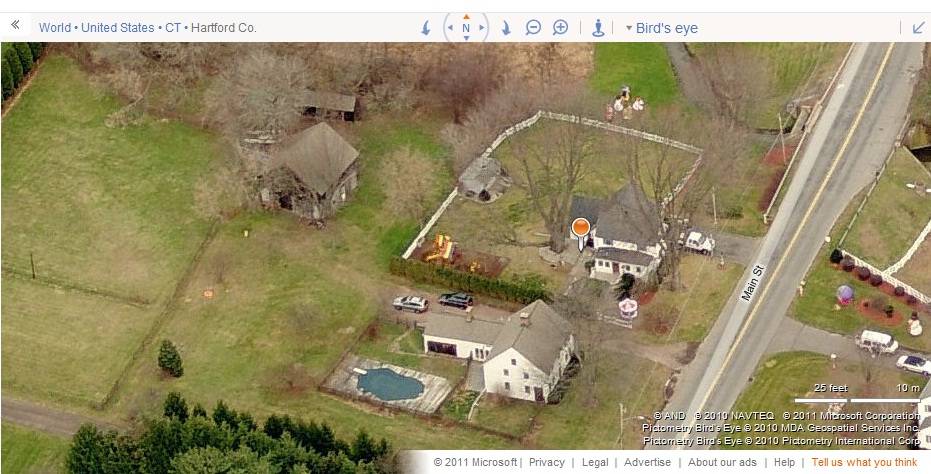
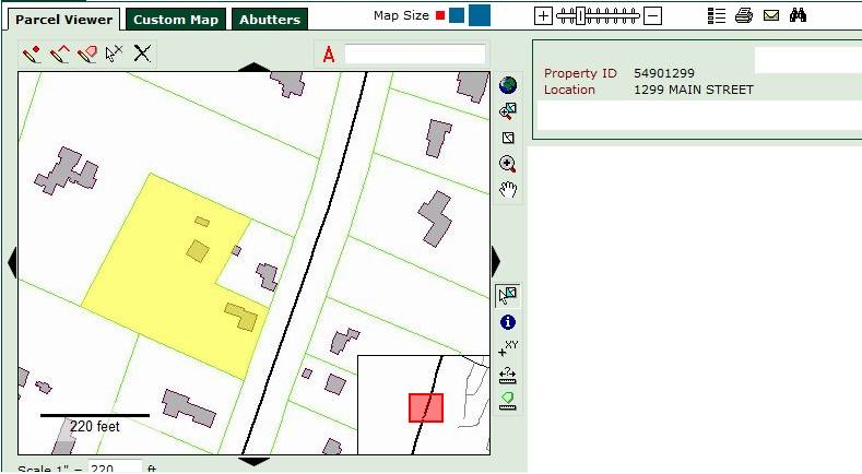
The 2 acres property, Account Number- 0007846 and Map Number- 83 6, is a L-shaped plot located towards the west of Main Street. The property is located in the rural-residential community of Windsor Farms Historic District on the National Register. Farm land with farm houses and barns can be seen towards the south, west north-east and the east of the property, across the road. A stream of water can be seen flowing towards the north of the property.
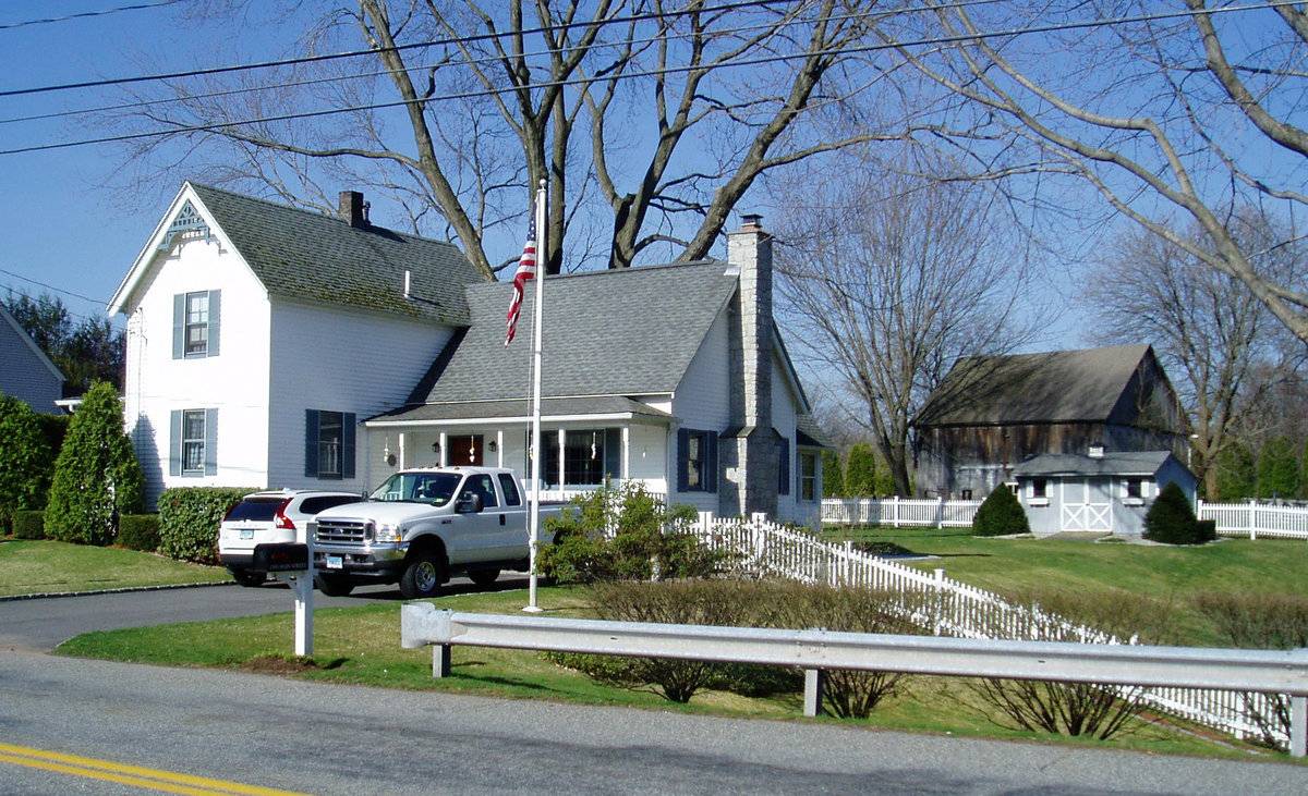
The barn is located in the northeast corner of the L-shaped property, offset from Main Street. The ridge line of the barn runs north-south parallel to the road. A small gable-roof shed is located towards the north of the barn with its ridge line running east-west perpendicular to the road. The circa 1810 colonial main residence of the property is located in the southeast corner of the property, nearer to the road. A pool can be seen towards the immediate southwest of the main residence. The property is accessed by a drive way towards the north of the main residence and continues northwest approaching the barn. The rest of the property toward the west and the south has open land.
- Typology & Materials
-
Building Typology
Materials
Structural System
Roof materials
Roof type
Approximate Dimensions
Barn: 1024 SqFt, Circa 1900; Shed: 160 SqFt, Circa 1900; Pool: 512 SqFt, Circa 1900;
- Source
-
Date Compiled
06/03/2011
Compiled By
T. Levine and M. Patnaik, reviewed by CT Trust
Sources
Field notes provided by: Dan Taylor, 09/06/2010.
Assessors’ information retrieved on June 3rd, 2011 from website www.southwindsor.org/pages/swindsorct_assessor/index
GIS Map and information retrieved on June 3rd, 2011 from website www.southwindsor.org/pages/swindsorct_dpw/gis/gis
Cunningham Jan, Edited by Herzan John, Windsor Farms Historic District, National Register Nomination Number-86000723, National Park Service, 1986.
http://pdfhost.focus.nps.gov/docs/NRHP/Text/86000723.pdf
http://pdfhost.focus.nps.gov/docs/NRHP/Photos/86000723.pdfO’Gorman, James F., Connecticut Valley Vernacular: the Vanishing Landscape and Architecture of the New England Tobacco Fields, University of Pennsylvania Press, 2002, 144 pages.
Photograph/Information retrieved on June 3rd, 2011 from website http://www.google.com
Photograph/Information retrieved on June 3rd, 2011 from website http://www.bing.com.
Photograph/Information retrieved on June 3rd, 2011 from website http://www.zillow.com.
Sexton, James, PhD; Survey Narrative of the Connecticut Barn, Connecticut Trust for Historic Preservation, Hamden, CT, 2005, http://www.connecticutbarns.org/history.
Visser, Thomas D.,Field Guide to New England Barns and Farm Buildings, University Press of New England, 1997.
- PhotosClick on image to view full file
-