Barn Record New Hartford
RETURN TO ‘FIND BARNS’- Building Name (Common)
- Ramstein barn
- Building Name (Historic)
- Ramstein barn
- Address
- 18 Ramstein Road, New Hartford
- Typology
- Overview
-
Designations
n/a
Historic Significance
Architectural description:
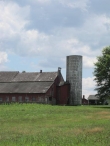
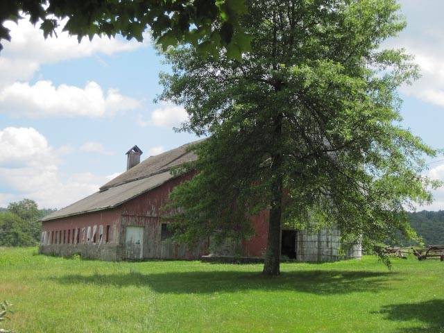
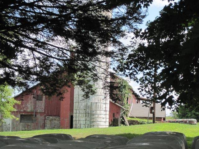
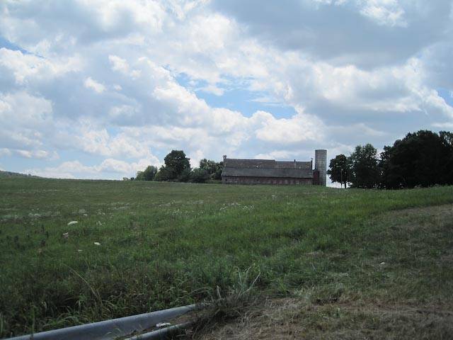
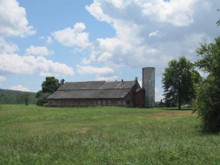
This is a large 1 ½-story eave-entry bank barn with a gable roof. Several additions have been added to this building, including a full-size tripartite gable-roof barn addition joined gable-end to gable-end to the east gable-end of the main barn (Addition I), and 1-story shed-roof addition along the north eave-side running the full length of the main barn plus Addition I (Addition II). A 1-story gable-roof bank addition projects to the south from the middle of the length of the main barn and Addition I (Addition III). A silo is connected to the west gable-end of this barn. The barn is situated roughly perpendicular to Ramstein Road, which passes this property at a nearly north to south angle.
The primary façade of this barn is the south eave-side. The main entry on this side is a centered pair of oversize doors, accessed by a stone ramp filled with earth, which leads to the raised first-story. No other openings appear to be visible on this façade. The west gable-end contains a wooden connection to the circular concrete silo, which is located adjacent to the southwest corner. This connection appears to have an off-set gable roof, sloping very low to the south. A pass-through size entry is located in this connection, just to the north of the silo. An external chimney is mounted to the center of the west gable-end. The northern portion of this end has a high mortared fieldstone foundation visible. The grade gently slopes down from south to north along this side.
The north eave-side is completely occupied by Addition II, a long shed-roof bank addition. The full basement level is exposed on this side, level with the grade, while the gable-attic is on the same level as the first story of the main barn. The west end of Addition II contains a wooden pass-through door in the northwest corner and a large rectangular opening to the south, covered with a sheet of plywood. The gable-attic on this end contains a single rectangular louvered vent near where the addition wall meets the main barn wall. The north eave-side is spanned by a row of fifteen evenly-spaced window openings down its length; six along the length of the main barn and nine along the length of Addition I. The east gable-end of Addition II appears to contain a pass-through door in the northeast corner. No other openings appear to be present.
Addition I is set to the immediate east of the main barn and is attached in parallel fashion gable-end to gable-end. The east gable-end of Addition I contains a rectangular opening near the roof ridgeline centered in the gable attic. A large external chimney, possibly of concrete and with a triangular chimney cap, extends above the roof line in the north half of this gable end. Addition I appears to be four bays in width. A raised earth ramp leads to an oversize entry on the raised first-story. A large shed-roof overhang projects off the main barn roof over this entry. Two foundation windows appear to be set into the basement level to each side of this ramp.
Addition III is a small 1-story gable-roof bank addition which projects to the south. The ridgeline of this addition is centered on the place where the connected gable-end to gable-end join the main barn and Addition I. This addition appears to have two window openings on the south gable-end. The east and west eave-sides of Addition III are not visible for the purposes of an Historic Resource Inventory.
The exterior of this barn and Addition I are faced with vertical wooden siding. Addition II is also faced in vertical wooden siding, of a different width. Exterior wooden walls are painted red. Portions of the mortared fieldstone foundation are visible, most notably a large portion on the west gable-end. A circular concrete silo, with no roof, is located adjacent to the southwest corner. The roof of the main barn and Addition I is covered with asphalt shingles. The roof of Addition II appears to be covered with mineral overlayed-asphalt. In addition to the external chimneys located on the west and east gable-ends, a small ventilator is located in the western half of the roof of the main barn, projecting up from the roof ridgeline.
Historical significance:The oldest barns still found in the state are called the “English Barn,” “side-entry barn,” “eave entry,” or a 30 x 40. They are simple buildings with rectangular plan, pitched gable roof, and a door or doors located on one or both of the eave sides of the building based on the grain warehouses of the English colonists’ homeland. The name “30 by 40” originates from its size (in feet), which was large enough for 1 family and could service about 100 acres. The multi-purpose use of the English barn is reflected by the building’s construction in three distinct bays - one for each use. The middle bay was used for threshing, which is separating the seed from the stalk in wheat and oat by beating the stalks with a flail. The flanking bays would be for animals and hay storage.
The 19th century saw the introduction of a basement under the barn to allow for the easy collection and storage of a winter’s worth of manure from the animals sheltered within the building. The bank barn is characterized by the location of its main floor above grade, either through building into a hillside or by raising the building on a foundation.
This innovation, aided by the introduction of windows for light and ventilation, would eventually be joined by the introduction of space to shelter more animals under the main floor of the barn.
Field Notes
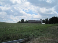
Possibly one of the best known barns in New Hartford as it is very visible from Rt. 202. This large dairy barn appears to have been built in stages. It is partially built in to the hill on the east side, giving better access to the loft and silo. The western addition of a long north-south bay would have substantially increased the number of cows. The silo has been missing its cap for well over a decade. Much of the surrounding land is now under conservation easement, but the barn is still private property.
- Use & Accessibility
Use (Historic)
Use (Present)
Exterior Visible from Public Road?
Yes
Demolished
n/a
Location Integrity
Unknown
- Environment
Related features
Environment features
Relationship to surroundings
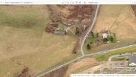
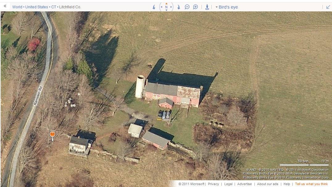
This barn is located roughly perpendicular to Ramstein Road, which passes this property at a nearly north to south angle. A gravel driveway leads from the road into this property, which ends on the south side of the barn. Opposing the barn to the south side of the driveway is a small pole barn and a garage. The house associated with this property is located to the south east of the barn, which looks out over a low-lying marshy area. A grassy lawn is located to each side of the driveway, which also leads to the house from the west end of the barn/garage area. A small grove of trees screens the house and barn’s west side from Ramstein Road. The barn’s north eave-side and silo are clearly visible, however, from CT Route 202, which passes along the northern boundary of this property at a northeast to southwest angle. A large field of active agriculture wraps around the barn from the southeast to the north, providing a clear sightline from CT 202. The surrounding area is primarily woodlands with scattered fields of active agriculture and open space, dotted with occasional dwellings. Ramstein Road meets CT 202 at a T intersection just to the north of the barn, beyond which is a large modern church complex.
- Typology & Materials
-
Building Typology
Materials
Structural System
n/a
Roof materials
Roof type
Approximate Dimensions
Barn 1-story W/Loft & Bsmt 4900 S.F.
- Source
-
Date Compiled
05/30/2011
Compiled By
N. Nietering & T. Levine, reviewed by CT Trust
Sources
Photographs by Anne C. Hall.
Sexton, James, PhD; Survey Narrative of the Connecticut Barn, Connecticut Trust for Historic Preservation, Hamden, CT, 2005, http://www.connecticutbarns.org/history.
Visser, Thomas D.,Field Guide to New England Barns and Farm Buildings, University Press of New England, 1997, 213 pages.
Map of New Hartford, CT, retrieved on May 26, 2011 from website www.bing.com.
New Hartford Assessor’s Records - Vision Appraisal online - http://data.visionappraisal.com/NewHartfordCT
- PhotosClick on image to view full file
-