Barn Record East Windsor
RETURN TO ‘FIND BARNS’- Building Name (Common)
- [ Part - 4 / 7 ] TO BE DEMO'D 2022 FOR GRAVEL PIT SOLAR INSTALLATION
- Building Name (Historic)
- n/a
- Address
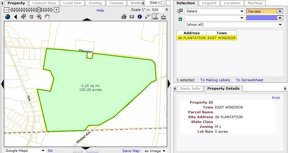
- 46 Plantation Road, East Windsor
- Typology

- Overview
-
Designations
n/a
Historic Significance
Architectural description:
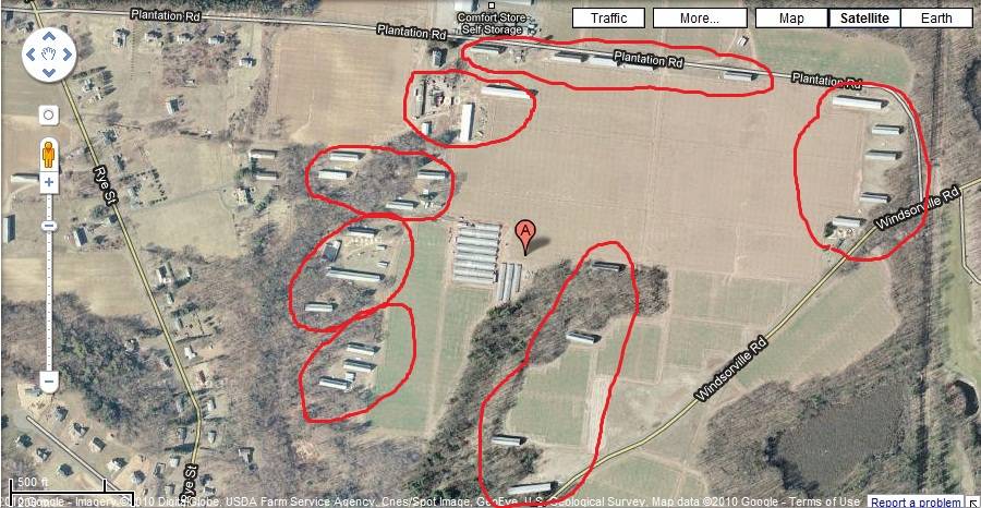
This is a barn complex of twenty-six tobacco sheds delineated into seven clusters based on their similar character and physical proximity: Cluster-A and Cluster-B with five tobacco sheds each, Cluster- C and E with four tobacco sheds each, Cluster-D with two tobacco sheds and Clusters- F and G with three tobacco sheds each.
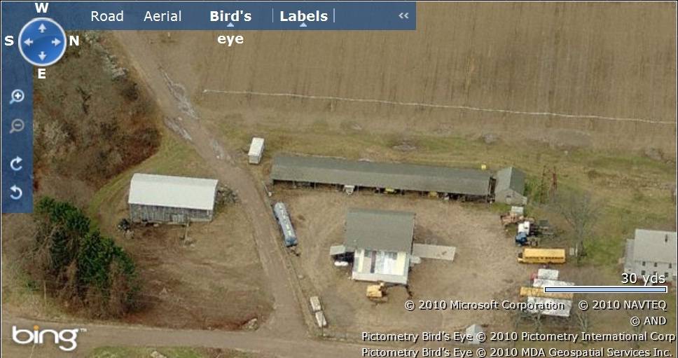
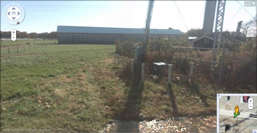
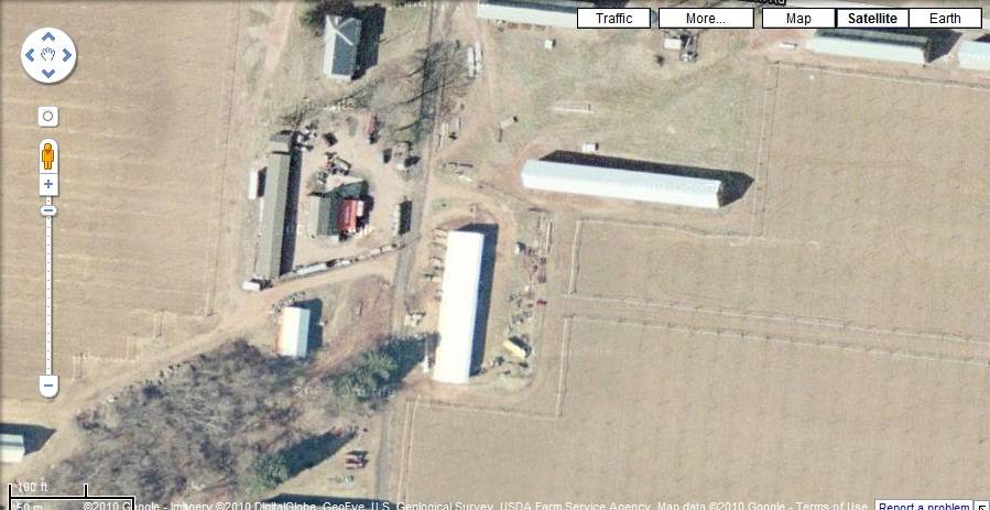
Cluster-D: This includes two 1 ½-story two aisle tobacco sheds towards the south-west of Cluster-A. Shed-D/I is towards the north-east with its ridge line running east-west parallel to Plantation Road. Shed-D/II can be seen towards the south-west with its ridge line running north-south. The two tobacco sheds are ventilated through the vertical siding on the eave-sides where every second board is hinged at the top and tilted out at the bottom by means of a horizontal cleat, that lifts many boards at once, and metal prop hooks to hold the boards in place. The wooden frames of the tobacco sheds are supported on concrete footings and have asphalt shingle roofing.
A 1 ½-story gambrel-roof barn, Barn-I, can be seen toward the east of Shed-D/II while another 1 ½-story two-aisle eleven-bent barn, Barn-II, with open bays along its east eave-side can be seen towards further east. A 1 ½ story eave-entry bank barn, Barn-III, can be seen towards the south-east of Barn-II while a small gable-roof shed is located towards the north.
Historical Significance:The tobacco barn, or shed as it is called in the Connecticut River Valley, is one of the most distinctive of the single-crop barns. They tend to be long, low windowless buildings with pitched roofs. They are characterized by vented sides to regulate air flow and allow harvested tobacco to cure at the appropriate rate. Derived initially from the design of the English barn, the shed is composed of a fixed skeleton consisting of two- or three-aisle bents repeated at intervals of 15 feet to the desired length. The wood-framed bents sit on piers of stone or concrete and the bents are connected by girts and diagonal braces. Typically there are two doors at each end, making the shed a “drive-through,” although some sheds are accessed through doors on the sides. The interior structural framework serves a second purpose in addition to supporting the walls and roof of the building; it provides a framework for the rails used to hang the tobacco as it cures.
This is accomplished with one of four different systems (more than one method may be utilized in a single shed):
a) Vertical slats - siding in which every second board is hinged at the top and tilted out at the bottom by means of a horizontal cleat, that lifts several boards at once, and metal prop hooks to hold the boards in place;
b) Side slats - Vertical siding in which alternate boards are hinged along the sides to open like tall narrow doors, each held in place by its own hook;
c) Less commonly, horizontal siding in which alternate boards are hinged along the top edge and open like long narrow awnings; this system may be employed along the lower edge of the wall in conjunction with vertical or side slats;
d) A series of large doors along one of the long sides of the building with the other sides of the building vented by one or more of the other methods.
e) The tobacco sheds can have additional ventilation through side-pivot awning vents on the gable-ends, which co-exist with one or more of the above four systems of ventilation.Field Notes
n/a
- Use & Accessibility
- Environment
Related features
Environment features
Relationship to surroundings
The approximately 158.4 acres property (0.25 square mile), Map number - 40 50 001, is a corner plot towards the south of Plantation Road and the north-west of Windsorville Road, situated in a residential area of rural character. Parcels of open land with active farming can be seen towards the north of the property across Plantation Road while residential plots can be seen along towards the west. A single residential plot can be seen along the northern edge of the property. Dense woodland surrounds the property towards the south and the south-west while parcels of farm land can be seen towards the south-east, across Windsorville Road.
The property has twenty-six tobacco sheds scattered over the site, separated by parcels of farm land or dense wood land. For easy identification and description, the site has been delineated into seven clusters of tobacco sheds of similar character or close proximity.
Cluster-A: This cluster includes five tobacco sheds along the northern edge of the property abutting to Plantation Road. The sheds are arranged in a row with their gable-sides facing each other. Shed-A/I is towards the west with Sheds-A/II, A/III, A/IV at the center and Shed-A/V towards the east. The ridge line of the tobacco sheds run east-west parallel to Plantation Road. A metal water tank can be seen towards the east of Shed-A/I. Parcels of open land with active tobacco farming can be seen towards the south of the tobacco sheds.
Cluster-B: This includes five tobacco sheds located in the north-eastern corner of the property. Shed-B/I is towards the north abutting to Plantation Road. Shed-B/II, Shed-B/III and Shed-B/IV are towards the south-east of Shed-B/1 arranged in three rows with their eave-sides facing each other. Shed-B/V is towards the south-west of Shed-B/IV. The ridge lines of the five tobacco sheds run east-west parallel to Plantation Road and parallel to each other. Parcels of open land with active tobacco farming can be seen towards the west and the south of the tobacco sheds while woodland along the eastern edge of the property shield the sheds from the road. A 1 ½-story gable-roof residence can be seen towards the south-west of Shed-B/V.
Cluster-C: This includes four tobacco sheds located in the south-eastern corner of the property with Shed- C/I towards the north. Shed-C/II is towards the south-west, separated from Shed-C/I by dense woodland. Sheds-C/III and C-IV can be seen towards further south-west of Shed-C/II, nearer to Windsorville Road. The ridge lines of the four tobacco sheds run east-west and are more or less parallel to each other. Parcels of farm land can be seen towards the east of the tobacco sheds while dense woodland can be seen towards the west.
Cluster-D: This includes two tobacco sheds towards the south-west of Cluster-A. Shed-D/I is towards the north-east with its ridge line running east-west parallel to Plantation Road. Shed-D/II can be seen towards the south-west with its ridge line running north-south. A 1 ½-story gambrel-roof barn, Barn-I, can be seen toward the east of Shed-D/II while another 1 ½-story two-aisle eleven-bent barn, Barn-II, with open bays along its east eave-side can be seen towards further east. A 1 ½ story eave-entry bank barn, Barn-III, can be seen towards the south-east of Barn-II while a small gable-roof shed is located towards the north. Parcels of farm land flank this cluster of tobacco sheds towards the east and the west while a residential plot can be seen towards the north of the cluster.
Cluster-E: This includes four tobacco sheds towards the south-west of Cluster-D, arranged in two columns separated by dense woodland. Shed-E/I is towards the west with Shed-E/III towards its south-west and Shed-E/II is towards the east with Shed-E/IV towards further south-west. The north eave-sides of the four tobacco sheds face Plantation Road while their ridge line runs east-west parallel to the road. Dense woodland surrounds the cluster towards the south and the south-west while parcels of farm land are towards the east. A few scattered sheds can be seen towards the east of Shed-E/IV.
Cluster-F: This includes the three tobacco sheds towards the south of Cluster-E arranged in three rows. Shed-F/I is towards the north, Shed-F/II in the middle and Shed-F/III towards the south-west. The north eave-sides of the three sheds face Plantation Road while the ridge lines run east-west parallel to each other and the road. A gable-roof outbuilding and two other gable-roof sheds can be seen separating Shed-F/I and Shed-F/II while dense woodland separates Sheds-F/II from Shed-F/III. Dense woodland can also be seen towards the west of the cluster while parcels of farm land can be seen towards the east.
Cluster-G: This includes the three tobacco sheds located in the south-western corner of the property arranged in three rows in close proximity to each other. Shed-G/I is towards the north, Shed-G/II in the middle and Shed-G/III towards the south-west. The ridge lines of the three sheds run east-west, more or less parallel to each other. Dense woodland surrounds the cluster on its north, west and the south while parcels of farm land can be seen towards the east.
Cluster-H: This includes the eleven green houses located at the center of the property in close proximity to each other. The ridge lines of eight of these sheds run east-west while that of the remaining three sheds run north-south. Parcels of farm land can be seen towards the north and the south of Cluster.
- Typology & Materials
-
Building Typology
Materials
Structural System
Roof materials
Roof type
Approximate Dimensions
n/a
- Source
-
Date Compiled
09/29/2010
Compiled By
T. Levine and M. Patnaik, reviewed by CT Trust
Sources
Photographs and field-notes provided by –
John Harmon, harmonjiii@gmail.comAssessors’ records retrieved on September 29th , 2010 from website http://www.equalitycama.com/
GIS information retrieved on September 29th , 2010 from website http://www.crcog.org/gissearch/
Photograph/Information retrieved on September 29th, 2010 from website http://www.google.com
Information retrieved on September 29th, 2010 from website http://www.zillow.com
O’Gorman, James F., Connecticut Valley Vernacular: the Vanishing Landscape and Architecture of the New England Tobacco Fields, University of Pennsylvania Press, 2002, 144 pages.
Sexton, James, PhD; Survey Narrative of the Connecticut Barn, Connecticut Trust for Historic Preservation, Hamden, CT, 2005, http://www.connecticutbarns.org/history
Visser, Thomas D.,Field Guide to New England Barns and Farm Buildings, University Press of New England, 1997.
- PhotosClick on image to view full file
-