Barn Record Stonington
RETURN TO ‘FIND BARNS’- Building Name (Common)
- Windmill & Barn
- Building Name (Historic)
- n/a
- Address
- 238 Farmholme Road, Stonington
- Typology

- Overview
-
Designations
n/a
Historic Significance
Architectural description:
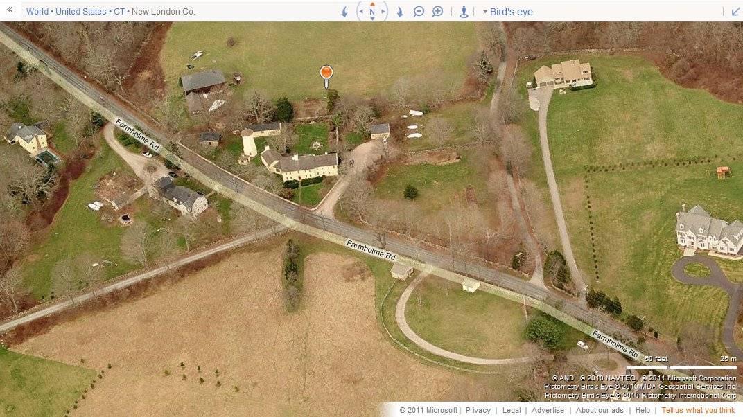
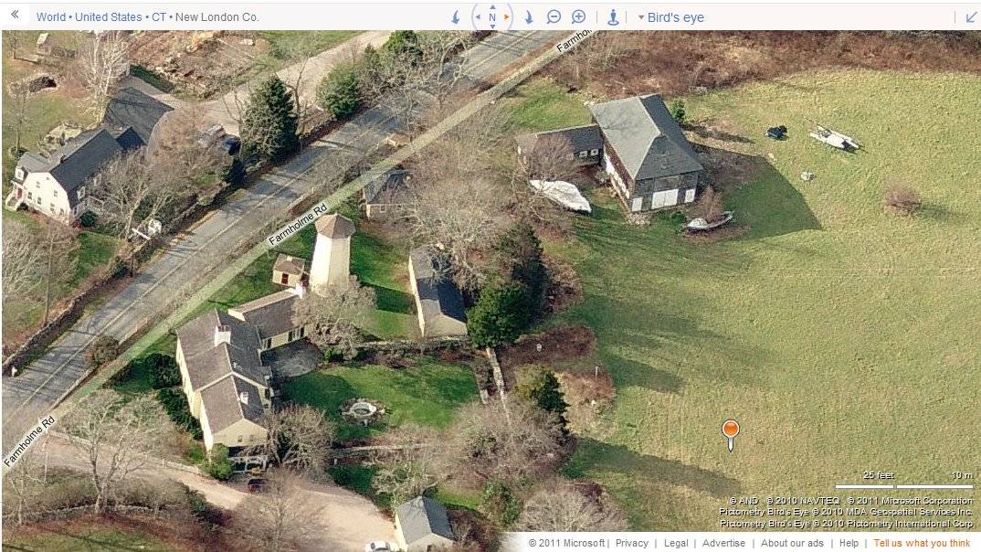
This is a complex of several agricultural buildings. A large barn with hipped roof and L shaped addition, clad in wood shingle, occupies the northern part of this site. A former windmill tower, sans blades, is joined by several smaller sheds and a larger wagon-shed. The property is situated along the north side of Farmholme Road north of Barnes Road. Farmholme Road passes this site at a northwest to southeast angle.
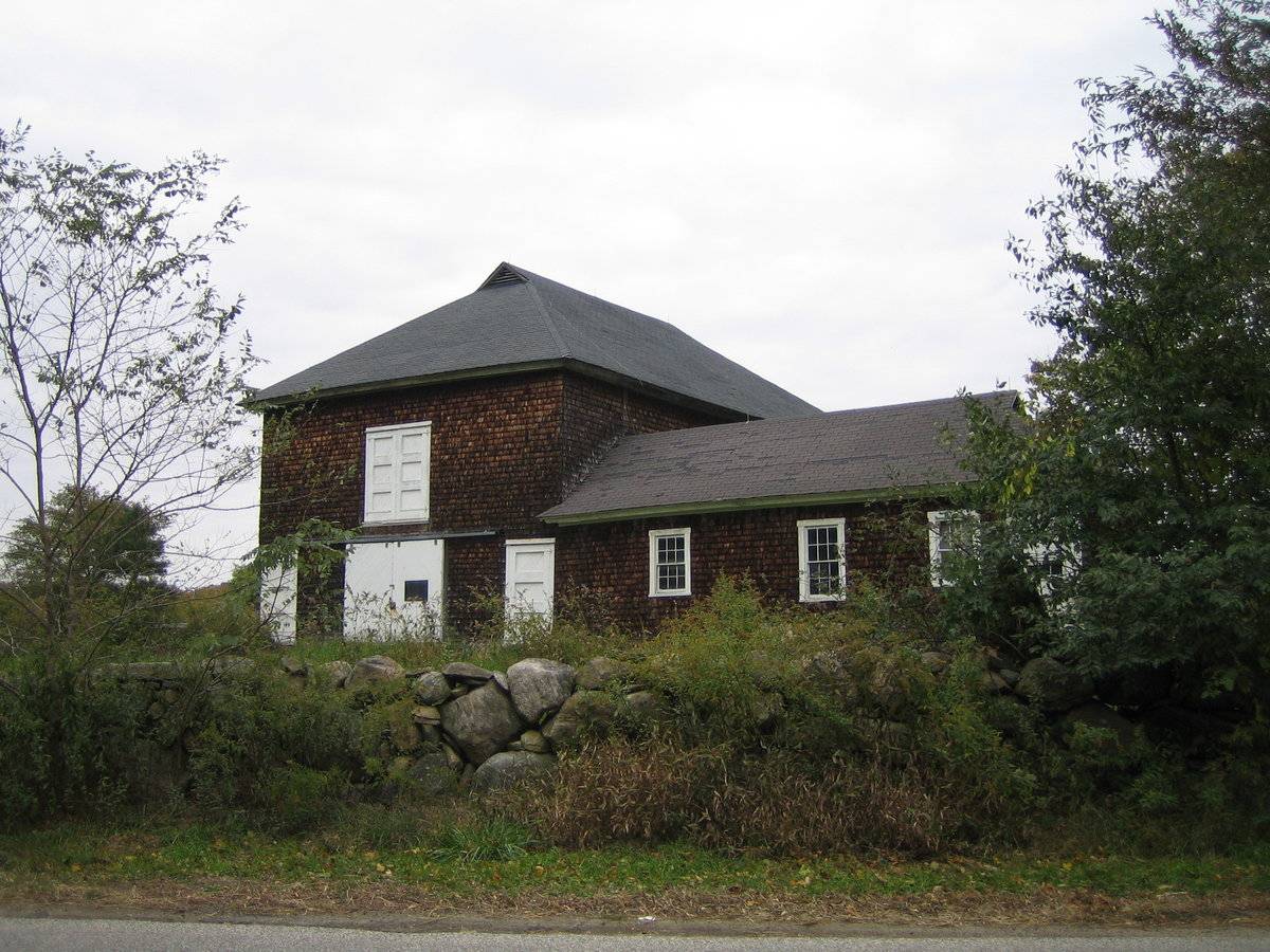
The main barn on this site is a 2 ½-story gable-entry barn with a hipped roof. The ridgeline is on an east to west axis. A single-story L shaped addition projects to the south from the western end of the south eave-side. The primary façade of the barn is the west gable-end, which faces Farmholme Road. The main entry on the façade consists of a pair of first-story centered sliding doors, of wooden construction, mounted on an overhead track. These are flanked by a wood panel pass-through door to each side at the outer corners. A pair of hinged wood panel doors are centered above the main entry doors on the second story. The north eave-side features many window openings on the first story. Nearest the northwest corner are two rectangular openings, followed by three slightly-higher small window openings. The eastern half includes five evenly-spaced window openings. The second-story appears blank.
The east gable-end appears to mirror the façade on the first-story, with a centered pair of sliding doors with a wood panel pass-through door to each side at the corner. Directly above the centered entry is a large opening which is covered by wood sheet, with four rectangular panels spanning the full width of this sheet just beneath the roof eave. The south eave-side contains several openings on the first-story. From the southeast corner working west, there are a series of five rectangular window openings, followed by a pass-through door, and another rectangular window opening. Projecting to the south from the western portion of the south eave-side is a 1-story hipped-roof addition. The east eave-side of this addition appears to have four unevenly-spaced window openings. The south gable-end of the addition appears to have two symmetrically-spaced window openings. The west eave-side, which is flush with the façade, includes three unevenly-spaced six-over-six double-hung windows, the center slightly taller than the outer two.
The exterior of this barn and addition is faced with wooden shingles. The roof surfaces are covered with asphalt shingle. Small triangular shaped louvered vents are located atop the gable-ends on the east and west ends.
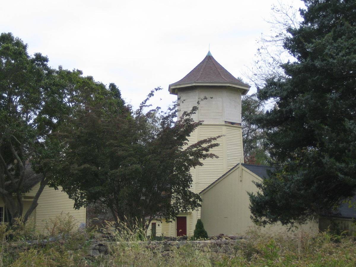
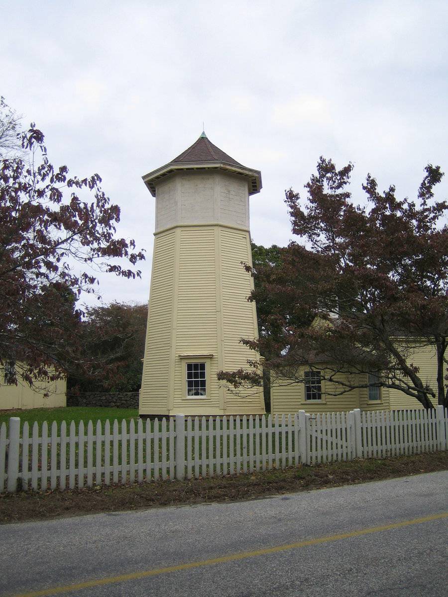
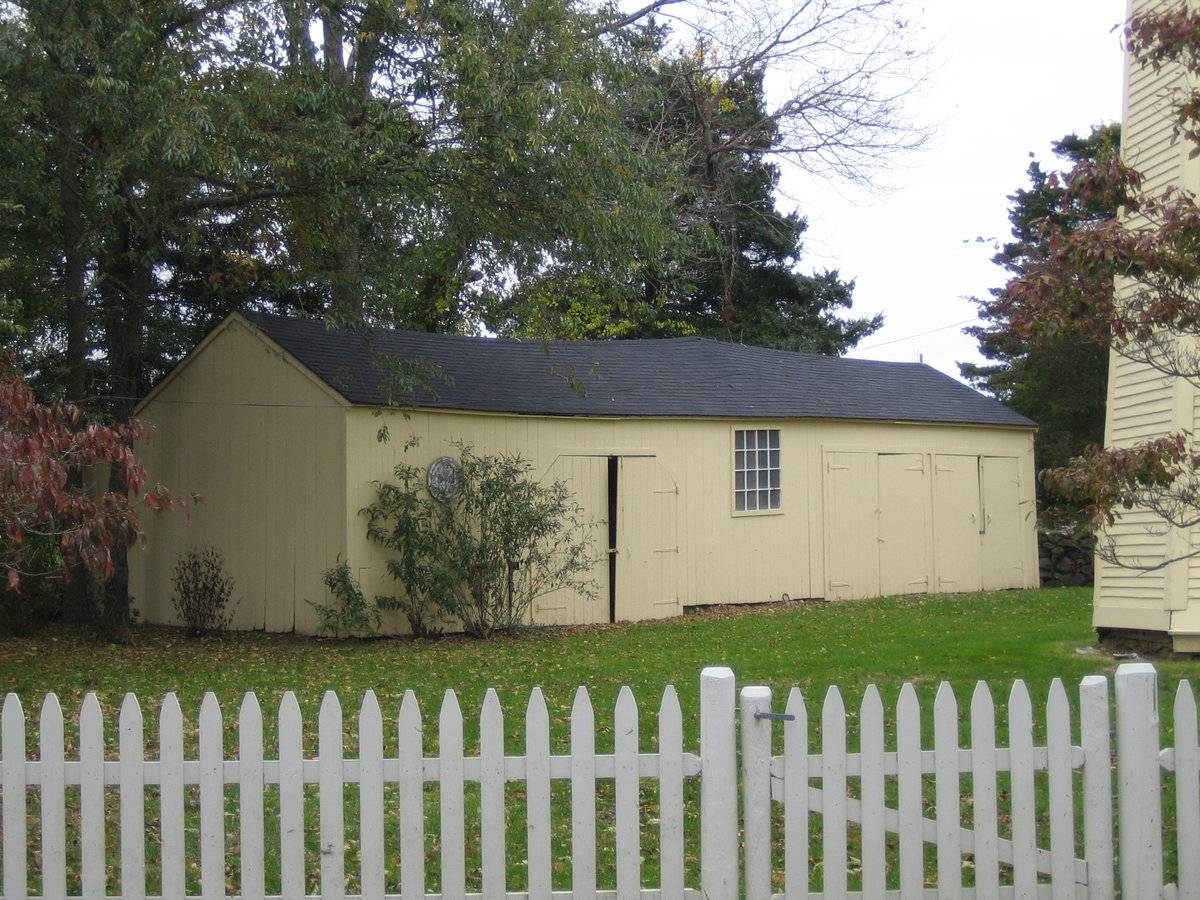
The remaining other agricultural structures on this site are all located to the southeast of the main barn. Aside from the large Federal-style farmhouse at the south end, also located on this site is the stand-alone former windmill tower, a wagon-shed, and two smaller outbuildings. All are unified by a common light cream paint color and some variety of wooden siding.The windmill tower is the central building of the complex. It is an eight-sided structure four-stories in height. The lower three stories are conical in shape, gently narrowing toward the top. The fourth-story is not conical and is faced with a different type of siding. The roof is an eight-sided pyramid rising to a center axis point, topped by a copper tip. The eaves of this roof are flared slightly.
The exterior faces of this windmill tower are generally blank. The east side features a wooden pass-through door on the first-story, with decorative wood moldings. The south, west, and north sides each feature a six-over-six double-hung window opening on the first-story, also with decorative trim. The lower three-stories are faced with wooden clapboard siding. The fourth-story is faced with horizontal wooden siding. The roof is clad with asphalt shingles.
To the immediate southwest of the mill tower is Shed I, a small 1-story building with a pyramidal roof. A centered wooden pass-through door is located on the southeast side. A six-over-six double-hung window appears to be centered in each the southwest, northwest, and northeast sides. This shed is faced with horizontal wooden clapboard siding.
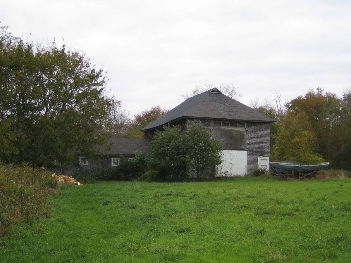
To the north of the windmill tower is a 1-story five-bay wagon-shed, with an east to west oriented ridgeline. The primary façade of this wagon-shed is the south eave-side. The eastern two bays each have a pair of hinged doors of wood-plank construction opening to the stalls within. The center bay contains an off-center sixteen pane window. The west-central bay contains another pair of hinged wooden doors; these are slightly shorter than the others and have clipped upper corners. The western bay contains a circular decorative element. The west gable-end is blank. The east gable-end is also blank. The north eave-side is not visible for the purposes of an Historic Resource Inventory. The exterior of this wagon-shed is faced with vertical wooden flush-board siding. The roof is of asphalt shingle cladding.
An additional shed on this property (Shed II) is situated to the west of the wagon-shed and the northwest of the windmill tower, but is not clearly visible for the purposes of an Historic Resource Inventory.
Historical significance:
The New England barn or gable front barn was the successor to the English barn and relies on a gable entry rather than an entry under the eaves. The gable front offers many practical advantages. Roofs drain off the side, rather than flooding the dooryard. With the main drive floor running parallel to the ridge, the size of the barn could be increased to accommodate larger herds by adding additional bays to the rear gable end. Although it was seen by many as an improvement over the earlier side-entry English Barn, the New England barn did not replace its predecessor but rather coexisted with it, as both types continued to be built.
Distinguished by the long shed or gable roof and the row of large openings along the eave side, the typical wagon shed was often built as a separate structure or as a wing connected to the farmhouse or the barn. These open-bay structures protect farm vehicles and equipment from the weather and provide shelter for doing small repairs and maintenance.
Field Notes
n/a
- Use & Accessibility
Use (Historic)
Use (Present)
Exterior Visible from Public Road?
Yes
Demolished
n/a
Location Integrity
Unknown
- Environment
Related features
Environment features
Relationship to surroundings
The structures on this site are divided into two groups. The main house associated with this property is surrounded to the north and northwest by the two sheds, and windmill tower, and the wagon-shed. These are all situated within a pentagonal-shaped yard, ringed by stone walls and tree lines in many cases. A white picket fence lines Farmholme Road along the property’s west side. Farmholme Road passes this site at a northwest to southeast angle. In addition to these various outbuildings, a modern garage is located to the northeast of the farmhouse, outside the stone wall. This garage is accessed by a gravel driveway which passes southwest to the point where it meets the road immediately in front of the house. The house and with all mentioned out-buildings are clad in some type of wooden siding, and all are painted a shade of cream. The second group consists of the main barn and its L-shaped addition, which are situated to the northwest of the first group. An old wooden sailboat hull, on blocks, is located to the east of the east gable-side, with a large tree growing through it. The barn is immediately surrounded by an agricultural field to the north and east. Additional agricultural fields and open land are located across Farmholme Road from this property to the south and west. Woodland surrounds these fields on all sides. Scattered dwellings are intermixed with the woodland and open space along Farmholme Road.
- Typology & Materials
-
Building Typology
Materials
Structural System
n/a
Roof materials
Roof type
Approximate Dimensions
n/a
- Source
-
Date Compiled
06/26/2011
Compiled By
N. Nietering & T. Levine, reviewed by CT Trust
Sources
Photographs by Lynn Friedman. lynnfrie123@yahoo.com
Sexton, James, PhD; Survey Narrative of the Connecticut Barn, Connecticut Trust for Historic Preservation, Hamden, CT, 2005, http://www.connecticutbarns.org/history.
Visser, Thomas D., Field Guide to New England Barns and Farm Buildings,
University Press of New England, 1997, 213 pages.Map of Stonington, CT, retrieved on June 24, 2011 from website www.bing.com.
Stonington Assessor’s Records - Southeastern Connecticut Council of Governments online - http://host.appgeo.com/sccog/Map.aspx
- PhotosClick on image to view full file
-