Barn Record Kent
RETURN TO ‘FIND BARNS’- Building Name (Common)
- Rock Cobble Farm Part 2 of 5
- Building Name (Historic)
- Rock Cobble Farm
- Address
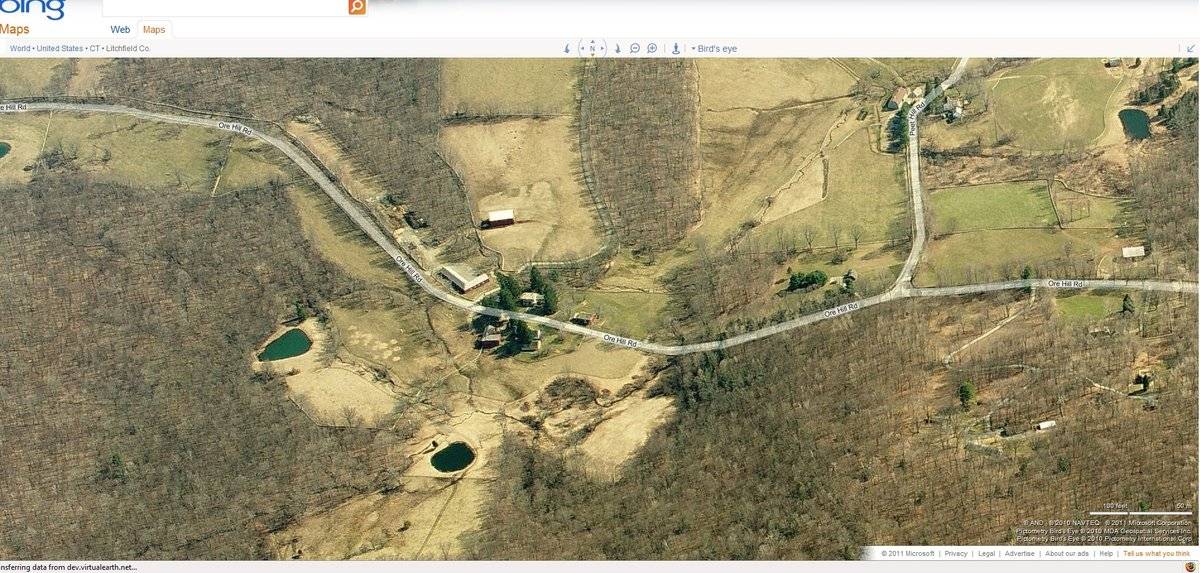
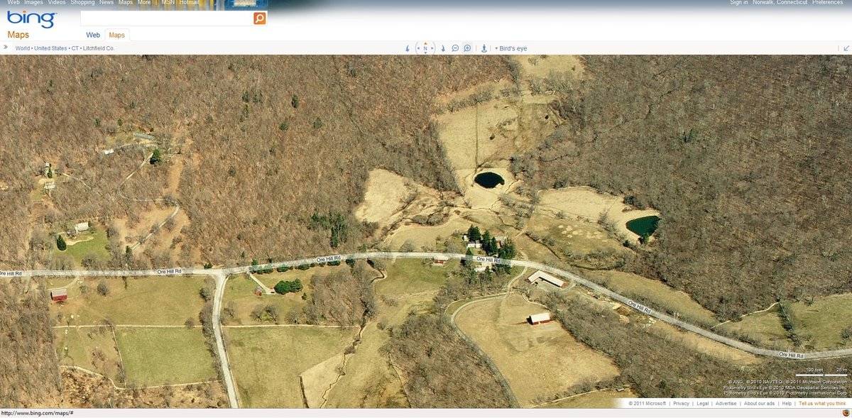
- 100 Ore Hill Road, Kent
- Typology

- Overview
-
Designations
n/a
Historic Significance
Architectural description:
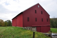
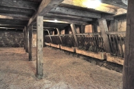
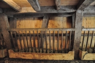
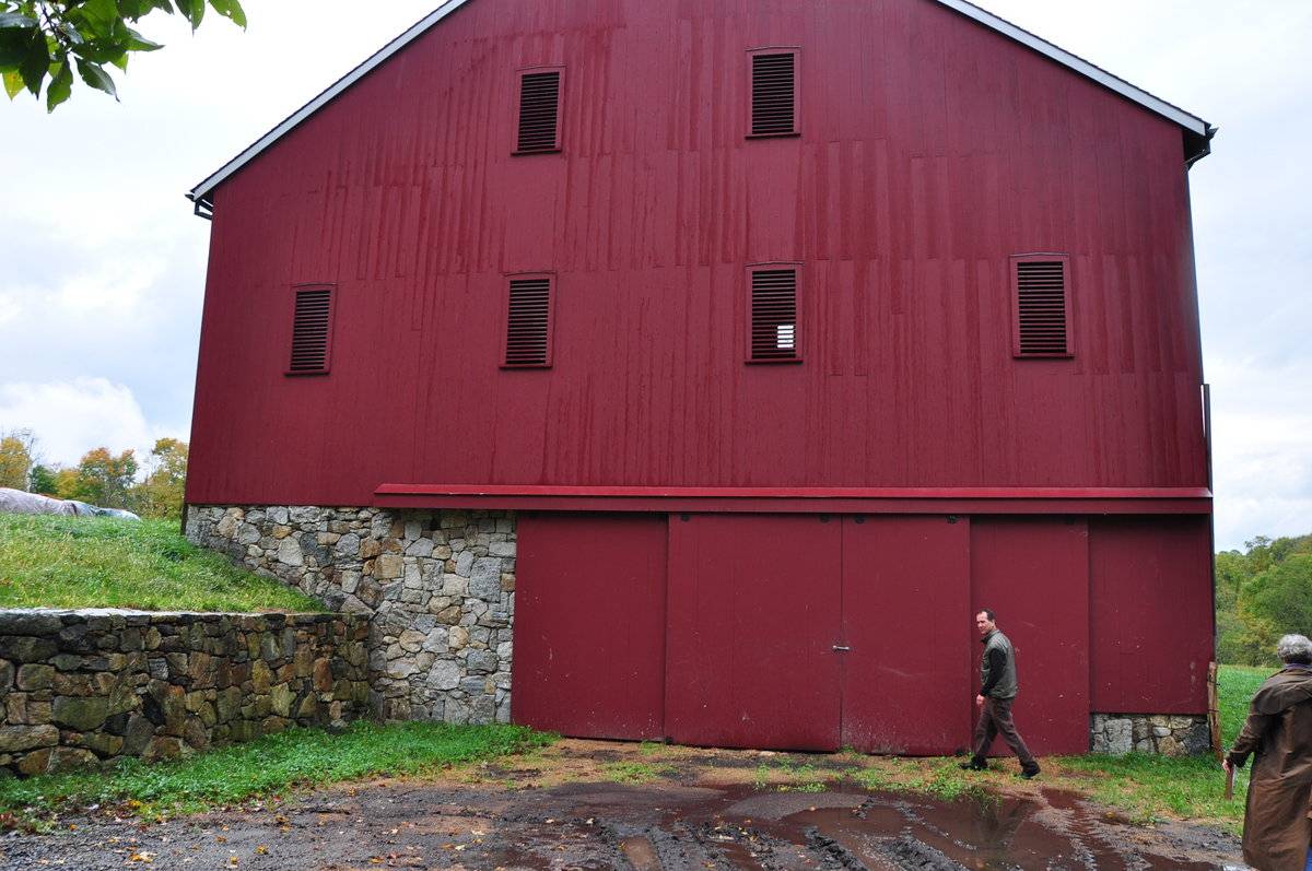
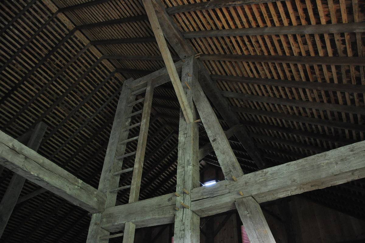
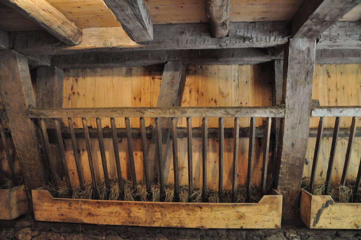
This is a 1 1/2-story eave-entry barn clad in vertical siding with the main facade facing predominantly south away from Ore Hill Road. The ridge line runs predominantly east-west, somewhat perpendicular to Ore Hill Road which at this point takes a brief diagonal turn running from northwest to southeast. The main entry of the south facade is a pair of sliding double doors mounted on an exterior track located in the central bay. The west gable-side elevation appears to be similar to the east elevation access to the basement level. The north eave-side elevation appears to have windows only. The grade decreases sharply toward the north eave-side of the barn so that the fieldstone foundation is exposed on the southern bay of the east and west gable-ends. On the northern half of the east gable-end, basement level are a pair of sliding double doors mounted on an exterior track. On the main level are four evenly spaced narrow vertical louvered windows. In the gable attic are two narrow vertical louvered windows directly above the two center louvered windows on the main level. Beneath the apex of the roof is a six-pane window centered in the gable. The vertical siding is painted red with white trim and the roof is clad in wood shingles. The structure of the barn is square rule construction with hardwood pegs with an integral ladder built into the framework. The barn sits on a fieldstone base which also serves as the basement wall on the southern half of the building. Integral hayracks for livestock are still intact in the basement area.
Historical significance:The oldest barns still found in the state are called the “English Barn,” “side-entry barn,” “eave entry,” or a 30 x 40. They are simple buildings with rectangular plan, pitched gable roof, and a door or doors located on one or both of the eave sides of the building based on the grain warehouses of the English colonists’ homeland. The name “30 by 40” originates from its size (in feet), which was large enough for 1 family and could service about 100 acres. The multi-purpose use of the English barn is reflected by the building’s construction in three distinct bays - one for each use. The middle bay was used for threshing, which is separating the seed from the stalk in wheat and oat by beating the stalks with a flail. The flanking bays would be for animals and hay storage.
Historical background:
From Kent Historical Society: “Ore Hill - the steep road that goes up (southeast) from the foot of Geer Mt. Road. There was the Spaulding Farm off the first steep part, on the right; up a little further, on the left where the Standens live, is an old Chase farmhouse that I don’t remember as a working farm, but the lands were extensive. The Benedict farm was located where Ore Hill Road turns to dirt (and eventually joins Treasure Hill Road). Turn around there, and go back & take a left down Peet Hill Road - (the one-room schoolhouse was smack in the middle of the intersection of Ore Hill Road & Peet Hill Road - torn down in the 50s). I remember the Hoffmans, who were tenant farmers for the old Samuel Peet Farm (the big stone house is still there, on the right) - but I can’t remember who owned it when the Hoffmans worked there. Bill Litwin bought the barn on the left and converted it into a house (now Ann Bass). I think Hoffman’s house (also on the left) was razed. Further down Peet Hill was (is) Bud Chase’s farm - he & wife Caroline were part of Triple A Ranch group who played country music & square dances. Caroline’s family, the Smyrskis, also had a farm at the end of Peet Hill Road right before it joins West Meetinghouse Road (the New Milford end of Camps Flat Road).”Also according to the Kent Historical Society many farmers in the area were tobacco farmers. Among those mentioned in the above article listed as tobacco farmers were the Benedict, Chase, and Peet families.
Many of these farms in the area were purchased in the late 1990’s and early 2000’s by Ann Bass the ex-wife of an oil billionaire from Texas who purchased a number of these farms and consolidated them to form “Rock Cobble Farm” which all together equal over 1000 acres. According to a newspaper article, in an effort to “restore her land to the condition it was in during the 18th century” Ms. Bass “tore down the houses and destroyed all the history” - two different perspectives. Point being, the barns and other structures on these properties may have been moved or altered. This barn was moved here from Monroeville, Pennsylvania.
Field Notes
Monroeville Barn Pennsylvania English Bank Barn 40 X 70 vertical siding post and beam wood shingle roof reconstructed on site. Used for cattle and hay storage.
- Use & Accessibility
Use (Historic)
Use (Present)
Exterior Visible from Public Road?
Yes
Demolished
n/a
Location Integrity
Moved
- Environment
Related features
Environment features
Relationship to surroundings
This property is located to the southwest of Kent among rolling hills, in a rural residential area with a few scattered farms. The barn is located on a 120.81-acre parcel that consists mainly of woodlands and open fields, a house and several agricultural structures. The barn is set back approximately 340 from and somewhat perpendicular to Ore Hill Road with its east gable-end sited toward the road with a large parking area and a thick stand of trees separating the barn from the road. Approximately 300 feet to the northeast of and located off of this same parking area is a large “L”- shaped shed sited closer to Ore Hill Road. The main ridgeline of this shed is parallel to the road with the secondary ridgeline perpendicular to the road. There are other small auxiliary farm structures sited in this parking area. Closer to Ore Hill Road and approximately 400 feet to the northwest is the 2-story main house, built in 1840 and Colonial in style. The ridge of the house’s gabled roof runs parallel to Ore Hill Road and its main facade faces north. The walls are clad in clapboard and the roof is clad in wood shingles. Adjacent to the house is a garage whose ridgeline runs parallel to the road. Running between the garage and the shed is a long driveway which leads to a tennis court (about 1500 from the house). Further west of the house along Ore Hill Road is a small barn which has been converted to a studio. Its ridgeline is parallel to the road. All of these buildings are set in a mixture of open pasture and stands of deciduous trees.
Map 12, Block 33, Lot 9- Typology & Materials
-
Building Typology
Materials
Structural System
Roof materials
Roof type
Approximate Dimensions
3080 sq. ft., 40 x 70
- Source
-
Date Compiled
02/23/2011
Compiled By
R. Rothbart & T. Levine, reviewed by CT Trust
Sources
Field notes and photographs by Dick Lindsey date 10/5/2010.
Vision Appraisal Online Database. http://data.visionappraisal.com/KentCT
Aerial Mapping:
Google Earth: 3/301991 - 8/30/2010http://maps.google.com
http://www.bing.com/maps accessed 02/23/2010.Sexton, James, PhD, Survey Narrative of the Connecticut Barn, Connecticut Trust for Historic Preservation, Hamden, CT, 2005, http://www.connecticutbarns.org/history.
Visser, Thomas D., Field Guide to New England Barns and Farm Buildings, University Press of New England, 1997.
Kent Historical Society Article on Agriculture: http://www.kenthistoricalsociety.org/the-history-of-agriculture-in-kent.htm
Kent Historical Society Article on Tobacco Growing: http://www.kenthistoricalsociety.org/tobacco-growing-in-the-housatonic-valley.htmNew York Times Article on Ann Bass, date 5/18/2007: http://www.nytimes.com/2007/05/18/nyregion/18bass.html
Kent Good Times Dispatch Article on Randall Cattle: http://www.randallcattleregistry.org/page10G.html, date 12/2/2005 - PhotosClick on image to view full file
-