Barn Record Bethel
RETURN TO ‘FIND BARNS’- Building Name (Common)
- n/a
- Building Name (Historic)
- n/a
- Address
- 79 Putnam Park Road (Rte 58), Bethel
- Typology

- Overview
-
Designations
n/a
Historic Significance
Architectural description:
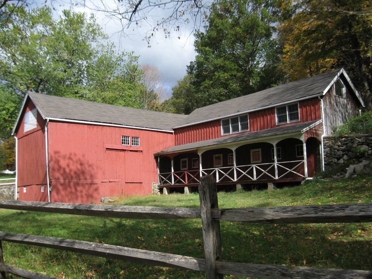
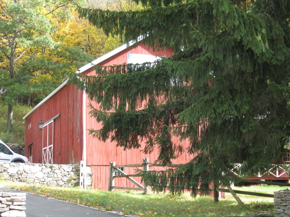
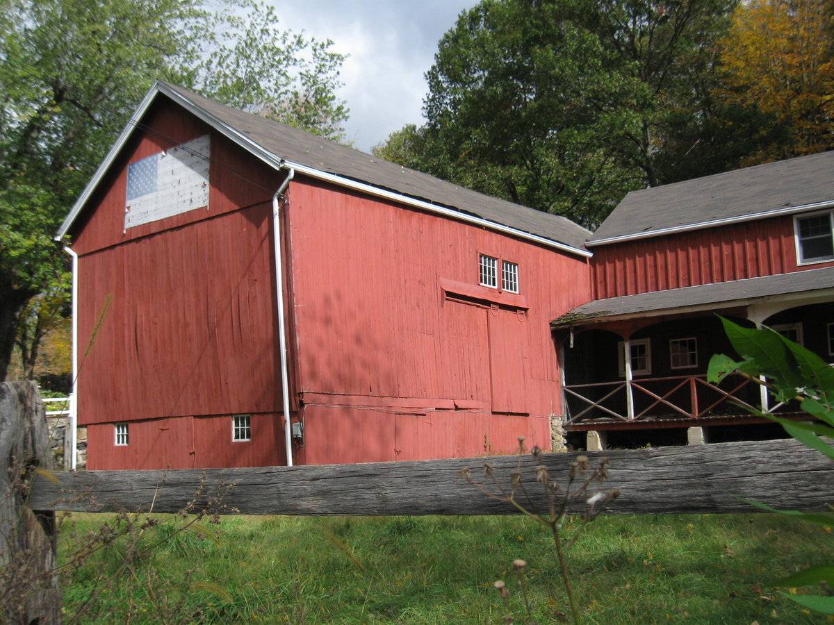
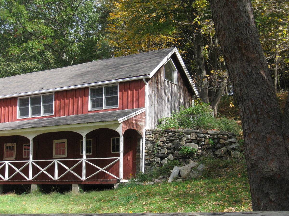
This is a L-shaped barn complex comprising of a 1 ½ - story three-bay eave-entry bank barn with an intersecting gable-roof addition on its south eave-side. The ridge line of the main barn runs east-west perpendicular to Putnam Park Road while that of the gable-roof addition runs north-south. The west gable-end of the main barn and the west eave-side of the intersecting gable-roof addition face the road. The three-bay north eave-side of the barn is the main façade of the complex with the main entrance centered in the middle bay through a pair of double-height X-braced hooded sliding wagon doors. The façade has a second entrance in the first bay from the east which appears to be through a pair of X-braced hinged wagon doors with a paired window centered above it, just below the eave level. The grade level along the main north eave-façade drops towards the west with the loose earth retained by un-coursed field-stone masonry foundation. The low grade level wraps around the barn to form the bank level along its west gable-end and the south eave-side. The bank level of the west gable-end of the barn is separated by a distinct siding divide line and has a hinged pass-through door at the center flanked by a six-pane window on either side. The first floor level of the west gable-end is blank with a distinct dropped girt siding divide line separating the gable attic. The gable attic lined by deep soffit has the national flag of USA displayed at the center. The bank level of the south eave-side of the barn has a hinged pass-through door towards the west. The first floor level of the south eave-side has an exterior-hung horse-shoe track sliding hay door at the center with two paired twelve-pane windows above. The west eave-side of the intersecting gable-roof addition has a semi-open shed-roof porch encompassing the entire length. The arcade porch is supported on six concrete piers and has X-braced railing. The first floor level of the gable-roof addition has seven six-pane windows, with trim around the first, third and the fifth windows from the north. The west eave-side of the gable-roof addition above the shed-roof porch has three closely spaced six-over-six double-hung sash windows at the center and two closely spaced six-over-six double-hung sash windows towards the south. The gable attic of the south gable-end of the gable-roof addition is lined by deep soffit and has a window at the center taking the profile of the apex of the roof.
The wooden frame of the main barn is supported on un-coursed field stone masonry foundation. The barn has asphalt shingles roofing and red painted vertical siding walls. The wooden frame of the intersecting gable-roof addition is supported on combination of concrete and field stone masonry foundation. The gable-roof addition also has asphalt shingles roofing but red painted board-and-batten siding on walls.
Historical significance:
The oldest barns still found in the state are called the “English Barn,” “side-entry barn,” “eave entry,” or a 30 x 40. They are simple buildings with rectangular plan, pitched gable roof, and a door or doors located on one or both of the eave sides of the building based on the grain warehouses of the English colonists’ homeland. The name “30 by 40” originates from its size (in feet), which was large enough for 1 family and could service about 100 acres. The multi-purpose use of the English barn is reflected by the building’s construction in three distinct bays - one for each use. The middle bay was used for threshing, which is separating the seed from the stalk in wheat and oat by beating the stalks with a flail. The flanking bays would be for animals and hay storage.
The 19th century saw the introduction of a basement under the barn to allow for the easy collection and storage of a winter’s worth of manure from the animals sheltered within the building. The bank barn is characterized by the location of its main floor above grade, either through building into a hillside or by raising the building on a
foundation. This innovation, aided by the introduction of windows for light and ventilation, would eventually be joined by the introduction of space to shelter more animals under the main floor of the barn.Field Notes
n/a
- Use & Accessibility
Use (Historic)
Use (Present)
Exterior Visible from Public Road?
Yes
Demolished
n/a
Location Integrity
Unknown
- Environment
Related features
Environment features
Relationship to surroundings
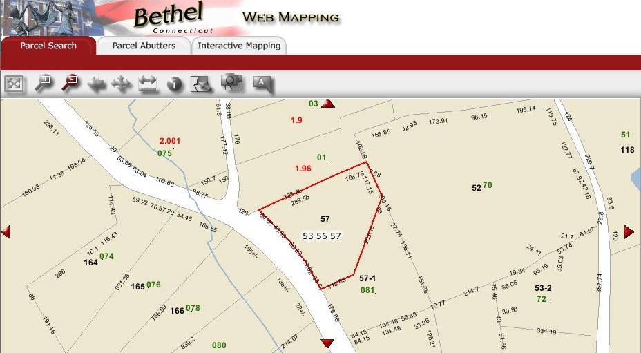
The 2.18 acres property, Account Number- R02629 and Map-block-lot number- 53 56 57, is located towards the east of Putnam Park Road, Route 58. The property is located in a pre-dominantly residential area of rural character with individual plots separated by woodland. Residential plots can be seen towards the north, east, south and the west of the property across the road.
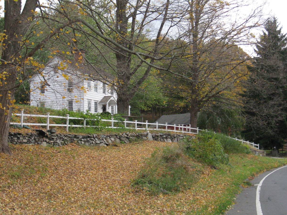
The L-shaped barn complex is located in the southwest corner of the property, abutting to Putnam Park Road. The ridge line of the main barn of the complex runs east-west, almost perpendicular to this portion of the road. The circa 1740 old style main residence of the property is located towards its north, separated by a driveway. A garage is located towards the northeast of the barn. A small pond is located towards the north of the main residence while a swimming pool can be seen towards the northeast. Dense woodland covers the area towards the south and the east.
- Typology & Materials
-
Building Typology
Materials
Structural System
Roof materials
Roof type
Approximate Dimensions
Barn: 10X20 Sqft, Circa 1900; Barn: 20X22 Sqft, Circa 1900; Barn: 24X50 Sqft, Circa 1900; Barn: 20X43 Sqft, Circa 1900; Pool: 16X35 Sqft, Circa 1900;
- Source
-
Date Compiled
06/13/2011
Compiled By
T. Levine and M. Patnaik, reviewed by CT Trust
Sources
Field notes and photographs provided by: Charlotte Hitchcock, 10/18/2010.
Assessors’ records retrieved on June 13th, 2011 from website http://bethel.univers-clt.com/
GIS Map/ information retrieved on June 13th, 2011 from website http://hosting.tighebond.com/bethelct/main.htm
Photograph/Information retrieved on June 13th, 2011 from website http://www.google.com
Photograph/Information retrieved on June 13th, 2011 from website http://www.bing.com.
Photograph/Information retrieved on June 13th, 2011 from website http://www.zillow.com.
Sexton, James, PhD; Survey Narrative of the Connecticut Barn, Connecticut Trust for Historic Preservation, Hamden, CT, 2005, http://www.connecticutbarns.org/history
Visser, Thomas D.,Field Guide to New England Barns and Farm Buildings, University Press of New England, 1997.
- PhotosClick on image to view full file
-