Barn Record Torrington
RETURN TO ‘FIND BARNS’- Building Name (Common)
- Wright's Barn Antiques & Flea Market
- Building Name (Historic)
- Wright, John W. and Belle, Dairy Farm; Wright's Country Club
- Address
- 104 Wright Road, Torrington
- Typology

- Overview
-
Designations
Historic Significance
Architectural description:
Barn I:
The main barn is a 2 ½-story Dutch gambrel-roofed ground level stable type barn, 37’ x 120’ with mortared fieldstone lower walls up to the window sills of the ground floor and horizontal Dutch lap wood siding. The barn was built as a large dairy barn and later converted to a teen dance club. Later it was converted again, to an antiques and flea market, which it remains at present.
Exterior:
The ground floor has 16 double-hung windows along each of the eave-side walls; these appear to be replacements for the original nine-paned steel sash, two of which remain on the east gable end. Above every second window is a projecting metal ventilator hood. The roof eave line is approximately six feet above the loft floor level. The south eave-side has an egress door cut in at the loft level near the west end, and a porch and stair leading to grade.
The west gable-end has a 1-story shed addition across the full width, and there are two small window openings high on the wall spaced apart. The north eave-side has a small gambrel-roofed addition projecting north near the west end, used as a pump room. At the east gable-end near the south corner there is a 1 ½-story gambrel-roofed addition, 14’ x 20’, originally the milk room; this has its ridge-line oriented east-west and is off-set southward so that it projects beyond the south wall of the main barn. These two wings appear to be original, as their style is consistent with the main barn structure.
The east gable-end also has a 1 ½-story shed-roofed addition spanning across the full width and extending beyond the north side wall, encompassing another shed-roofed addition off the north eave-side wall, containing the boiler room for the heating system. The two shed additions appear to date from the 1960s or later, being in a style not consistent with the gambrel roofs of the original construction. The east ground level façade has two entrance doors with triple panels of double-hung windows filling the remainder of the wall above a stone base. Above the roof a shed-roofed portion projects from the east gable-end wall of the main barn, housing a stair accessing the loft level. The upper gable-end wall of the barn has a pair of enormous hay doors with x-bracing and small windows in each leaf. These doors operated by sliding diagonally downward on a pulley system, retained by a spacer bar at the sill.
The roof has a projecting hay hood over the hay doors and two metal ventilators on the ridge. A brick chimney projects from the ridge; this vents a fireplace at the ground level, added during the barn’s use as a teen night club.Interior:
The interior of the ground floor is finished and occupied by a series of flea market rental areas. Near the east wall along the south side is a soda fountain area and on the north side a fireplace with a diagonal stone facing. Two rows of steel columns running longitudinally support girders, which carry the loft level floor structure. Walls and ceiling are finished and painted.
The interior of the upper, or loft level, is also finished, with a ceiling suspended just above the purlin level. At the west end, triangular trusses supporting the gable-end wall are exposed; the remainder of the structure is concealed by wall finishes.
The eastern shed addition encloses an area that was used as a lobby for the dance club and now contains a stair to the upper level as well as a double door entry to the ground floor.
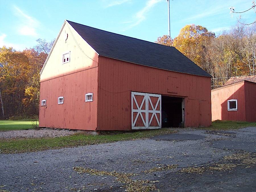
Barn II, Horse barn:
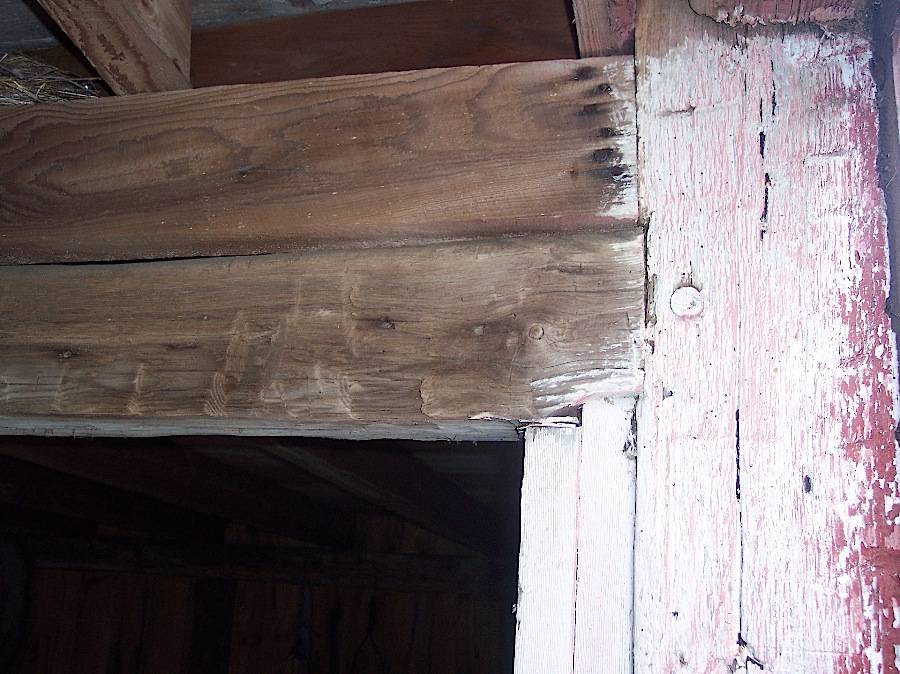
This is a three-bay English barn approximately 25’ x 35’, oriented with its ridge-line north-south and its east eave-side facing the road. A sliding barn door in the east gable-end is the primary entrance. A pair of hinged door in the north bay appears to be a later construction. A small hay door is above the center doorway, and three stable windows are in the south gable-end. The exterior is vertical board siding painted red. The roof is asphalt shingles. The foundation is not exposed to view.The interior has a square rule post and beam frame. The attic has hewn common rafters mortised into a ridge pole, random width wide board decking, and an old hay track rod suspended below the ridge. The bents have dropped tie girts and one interior post at the center of each bent. The rafters span from eave to ridge without any purlins or posts. The south bay has been altered by converting it to horse stables. For this purpose, the center post in the southern interior bent was truncated and its function replaced by a series of steel columns offset toward the north. The interior of the stall area is divided into three stalls with metal grilles in the upper part; the ceiling and upper walls are whitewashed. Some of the metal hardware such as column caps, has the name “Jamesway” cast into the surfaces, indicating the iron fittings were purchased from the Jamesway Company, providers of much agricultural equipment in the early 1900s.
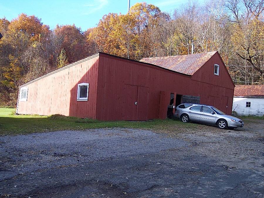
Barn III:
This is a roughly 30’ x 60’ structure consisting of a gable-roofed barn with its ridge-line oriented east-west, and a shallow-pitched shed roof wing attached to the south side. The gable-roofed section has three pairs of hinged doors in the east side. The shed-roofed section has two bays and two pairs of doors.
The gable-roofed portion has pressed metal shingle roofing while the shed-roofed portion has asphalt shingles. Siding is vertical boards painted red. There are several small window openings with beveled head trim, the trim painted white. The shed-roofed portion has noticeable deflection visible from the west view.
The interior of the gable-roofed section is a square rule post and beam structure with two bays. The original structure has been reinforced and patched. The roof has two longitudinal purlin plates with hewn rafters. Some members have been replaced with dimension lumber. The interior of the south wing has a shallow truss running in a north-south direction, supporting the rafters at mid-span. Most of the material is sawn dimension lumber with some heavy timbers. Barn III appears to have been used for equipment storage and repair.Historic significance:
By the early 20th century agricultural engineers developed a new approach to dairy barn design: the ground-level stable barn, to reduce the spread of tuberculosis bacteria by improving ventilation, lighting, and reducing the airborne dust of manure. A concrete slab typically serves as the floor for the cow stables. Many farmers converted manure basements in older barns into ground-level stables with concrete floors. Some older barns were jacked up and set on new first stories to allow sufficient headroom. With the stables occupying the entire first story, the space above serves as a hayloft. By the 1920s most ground-level stable barns were being constructed with lightweight balloon frames using two-by-fours or two-by-sixes for most of the timbers. Novelty or tongue-and-groove beveled siding is common on the walls, although asbestos cement shingles also were a popular sheathing. Some barns have concrete for the first-story walls, either poured in place or built up out of blocks.
The gambrel roof design was universally accepted as it enclosed a much greater volume than a gable roof did, and its shape could be formed with trusses.Historical background:
The barn and its farmstead setting are significant for the excellent integrity of the building and setting, as representing the peak period of Connecticut dairy farming from the 1930s to the 1950s. The barn is also uniquely significant for its history as the Wright’s Country Club, a popular local institution during the period of the 1960s. John J. and Mildred Wright provided an important social center for youth during that period, and received public appreciation, including a Torrington High School yearbook dedication in 1972.
Torrington was settled in the 18th century by residents from Windsor; property-owning residents were given the townships to divide among themselves, and assignment of land to the proprietors was by lot. Following the division of land, the areas that were first settled were the uplands to the west and east of the Naugatuck River, where the land was most suitable for farming. Settlement occurred to the east at Torringford and to the west in the West Side (Highland Avenue) area and at Torrington Green, located at today’s intersection of University Drive and Hodges Hill Road. The road now called Wright Road, formerly turned eastward just north of the Farmhouse and extended downslope across Nickel Mine Brook to meet the north-south road in Torrington Green, now University Drive.The Beers Map of 1868 shows A. Whiting at this site; Alonzo and Rebecca Whiting are listed in the 1870 census in sequence with M. Burns and S. Barber, the neighbors per the map. Hence it may be inferred that the Farmhouse was in existence prior to 1868. Barn II and part of Barn III likely date from the 19th century as well.
By the early 20th century, Clark Weed and his wife Bertha are at the site, and in 1936 they sold the farm to John W. and Belle Wright. As told by the current owner, Jim Wright, Weed was a gentleman farmer who had remodeled the Farmhouse, turning it 90 degrees (to face south instead of toward the road and barns), removing the center chimney, and adding the stone-walled porch.
The Wrights had previously lived in Barkhamsted Hollow but were bought out in 1936 for the construction of the reservoir. At that time they purchased the Weed farm and moved here. During the early 1940s there were so-called “state boys,” foster children, placed on the farm as workers. One of these boys burned the barn and another building, the original home of the first pastor of the church at Torrington Green. The present barn was built in 1941 as a replacement.The Wright family, including John W. and Belle and their son John J. Wright and his wife Mildred Blackman Wright, operated the dairy farm, with Guernsey cows, for almost two decades longer. There were two silos along the southwest corner and a manure pit to the west of the barn. In 1958 the dairy operation was ended and the cows were sold. Of the Wrights’ three children, John, Jill, and James (Jim), the youngest, Jim, has remained in Torrington and now owns the property.
In 1963 a new use was devised for the barn. John J. and Mildred Wright renovated the ground floor with the help of local youth as a teen dance club, “Wright’s Country Club,” adding a soda fountain and fireplace near the east end and tables along the south wall. Popular bands played on weekends, providing a social center for area teens for ten years until in 1972 the legal drinking age in Connecticut was changed from 21 to 18 (it was raised again in 1985). With older teens able to attend adult venues, the viability of the club collapsed.Subsequently, the Wrights converted the barn into an antiques and flea market, finishing the loft interior with a ceiling and wall finishes as well as egress doors and stairs. The building now functions as a market, open weekends, with vendors renting space along the central aisles of the ground and upper levels.
Architectural significance:
The barn and its farmstead setting are significant for the excellent integrity of the building and setting, as representing the peak period of Connecticut dairy farming from the 1930s to the 1950s. This is a large structure with originally a fully-developed ground level, hay loft, and milk processing facility. The barn is also uniquely significant for its history as the Wright’s Country Club, a popular local institution during the period of the 1960s. John J. and Mildred Wright provided an important social center for youth during that period, and received public appreciation, including a Torrington High School yearbook dedication in 1972. The unique re-use of this structure, first as a dance club and later as a retail facility, reflect the potential of these barn structures to continue in productive use.Field Notes
Listed on the State Register of Historic Places 9/04/2013. This former dairy barn was converted into a teenage dance club which served Litchfield County youth from 1965-1975. In 1980 John & Millie Wright opened the flea market and soon expanded to include a second floor. Now managed by Jim Wright, the flea market has over 40 spaces available with many dealers occupying multiple spaces. Currently 20 dealers have been at the barn from 2 to 20 years. Other dealers may come from week-to-week and all vendors constantly display new items. Vendors tend to specialize in various antiques and collectibles uncluding: furniture, jewelry, paper goods, books, china and glassware; Victorian-style artwork and furniture. Find tools, garden implements, reproduction period pieces from the 20's-60's. So if you collect salt and pepper shakers, hummels, antique pins, movie posters, magazines, or Wallace Nutting prints, come to Wright's Barn.
- Use & Accessibility
- Environment
Related features
Environment features
Relationship to surroundings
The site is located northwest of the center of Torrington near the top of a southeast-facing hillside in an area that was among the first to be settled by English colonists moving from Windsor. Wright Road extends northward from Goshen Road (Route 4); the road originally turned eastward and connected through to University Drive (formerly Town Farm Road). A historic site, the birthplace of abolitionist John Brown, is nearby to the north. Nickel Mine Brook runs down to the Naugatuck River in the valley to the east. The area is a mix of open former farmland, woods (now water supply land), and recent residential development. The ruins of old nickel mines, factory sites, and old homesteads are vanishing into second growth forests.
The earliest areas of Torrington to be settled included the uplands on both sides of the Naugatuck River. Historic properties on the west side include the Strong House at 1167 Highland Avenue, listed on the State Register of Historic Places, and the John Brown birthplace, listed on the Connecticut Freedom Trail; the area was the site of the earliest English settlements. Also included in this thematic nomination to the State Register is the nearby Mount Pleasant Farm at 505 University Drive. East of the river, the Torringford National Register Historic District along Torringford Road (Route 183) includes historic homes, a number of which have associated barns, as this was the best farmland in the town. In the 19th century, the focus of development shifted to the river valley where industries arose and thrived. Several historic districts and properties are located in the downtown area.
This site includes several parcels on both the west and east sides of Wright Road. On the west, from south to north, are Barn I, a large gambrel-roofed ground level stable-type barn; Barn II, a small English barn; and Barn III, a small barn with a shed addition. On the east side of the road there is a Farmhouse and several other residential structures.The Farmhouse is a mid-19th-century 2 ½-story gable-roofed building with its ridge-line oriented east-west. The main block is 27’ x 34’ and a wing extends to the north. The main entry is in the five-bay south-facing eave-side, which has a 2-story columned porch across the center three bays. The porch has a foundation and low perimeter wall of rusticated stone blocks, slender Doric-style columns, and a hip roof with a shallow pediment over the center of three bays. The gable-end facing the road has a pedimented attic with a pair of double-hung windows. The lower floors each have three double-hung windows. Siding is vinyl and windows have been replaced. Roofing is asphalt shingles.
- Typology & Materials
-
Building Typology
Materials
Structural System
Roof materials
Roof type
Approximate Dimensions
37' x 120'
- Source
-
Date Compiled
08/23/2011
Compiled By
C. Hitchcock, reviewed by CT Trust
Sources
Photographs and field notes by Jim Wright, 8/23/2011, Charlotte Hitchcock, 7/11/2012.
Interview with Jim Wright, 7/11/2012, at the site; photographs and scrapbook clippings courtesy of Jim Wright.Map resources:
Town of Torrington Assessor’s Record http://www.equalitycama.com/tvweb/Details.aspx?city=Torrington&uid=15375 Parcel ID: 214/002/012
Aerial views from:
http://maps.google.com/ 8/08/2012 and http://www.bing.com/maps/ accessed 6/21/2011.Historical aerial photography and maps accessed at UConn MAGIC:
http://magic.lib.uconn.edu/mash_up/1934.html
http://magic.lib.uconn.edu/historical_maps_connecticut_towns.html .
Bailey, O.H., View of Wolcottville Conn, O.H. Bailey, Boston, 1875-8.
Bailey, O.H., Bird’s Eye View of Torrington Conn, Hughes & Bailey, New York, 1907.
Beers, F.W., Atlas of Litchfield County, F.W. Beers & Co., 1874.
Norris, George E., Torrington Conn. 1889, Geo. E. Norris, Brockton Mass, 1889.USGS Historical Maps accessed 6/22/2012 at http://historical.mytopo.com/ .
UTM coordinates: http://itouchmap.com/latlong.html .
Print and internet resources:
Andrews, Gregory E., Torringford Street National Register Historic District No. 91000991, National Park Service, 1991.
Connecticut Monuments, John Brown Birthplace, http://ctmonuments.net , accessed 8/03/2013.
James Manufacturing Co., The James Way, Fort Atkinson, Wisconsin, 1919 (Cornell University Library).
McEachern, Mark, & Clapp, Carol, Strong, Jacob, Jr., House State Register Nomination, Torrington Historical Society & Connecticut State Historic Preservation Office, Hartford CT, 2012.
Sexton, James, PhD; Survey Narrative of the Connecticut Barn, Connecticut Trust for Historic Preservation, Hamden, CT, 2005, http://www.connecticutbarns.org/history.
Reilly, Megan, State of Connecticut Office of Legislative Research, “Lowering the drinking age,” 2009, www.cga.ct.gov/2009/rpt/2009-R-0081.htm .
U.S. Federal Census, accessed at http://persi.heritagequestonline.com/hqoweb/library/do/census/search/basic .
Visser, Thomas D., Field Guide to New England Barns & Farm Buildings, University Press of New England, 1997.
- PhotosClick on image to view full file
-