Barn Record Waterbury
RETURN TO ‘FIND BARNS’- Building Name (Common)
- Hobart Victory Welton Carriage Shed (the Arch)
- Building Name (Historic)
- Hobart Victory Welton Carriage Shed
- Address
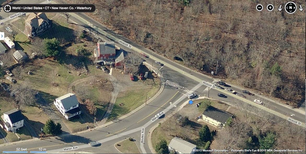
- 0 Manor Avenue and Wolcott Street, Waterbury
- Typology

- Overview
-
Designations
Historic Significance
Architectural description:
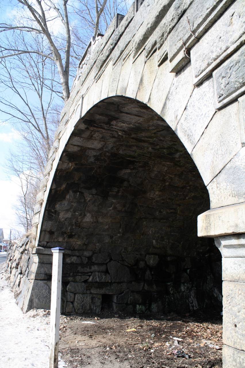
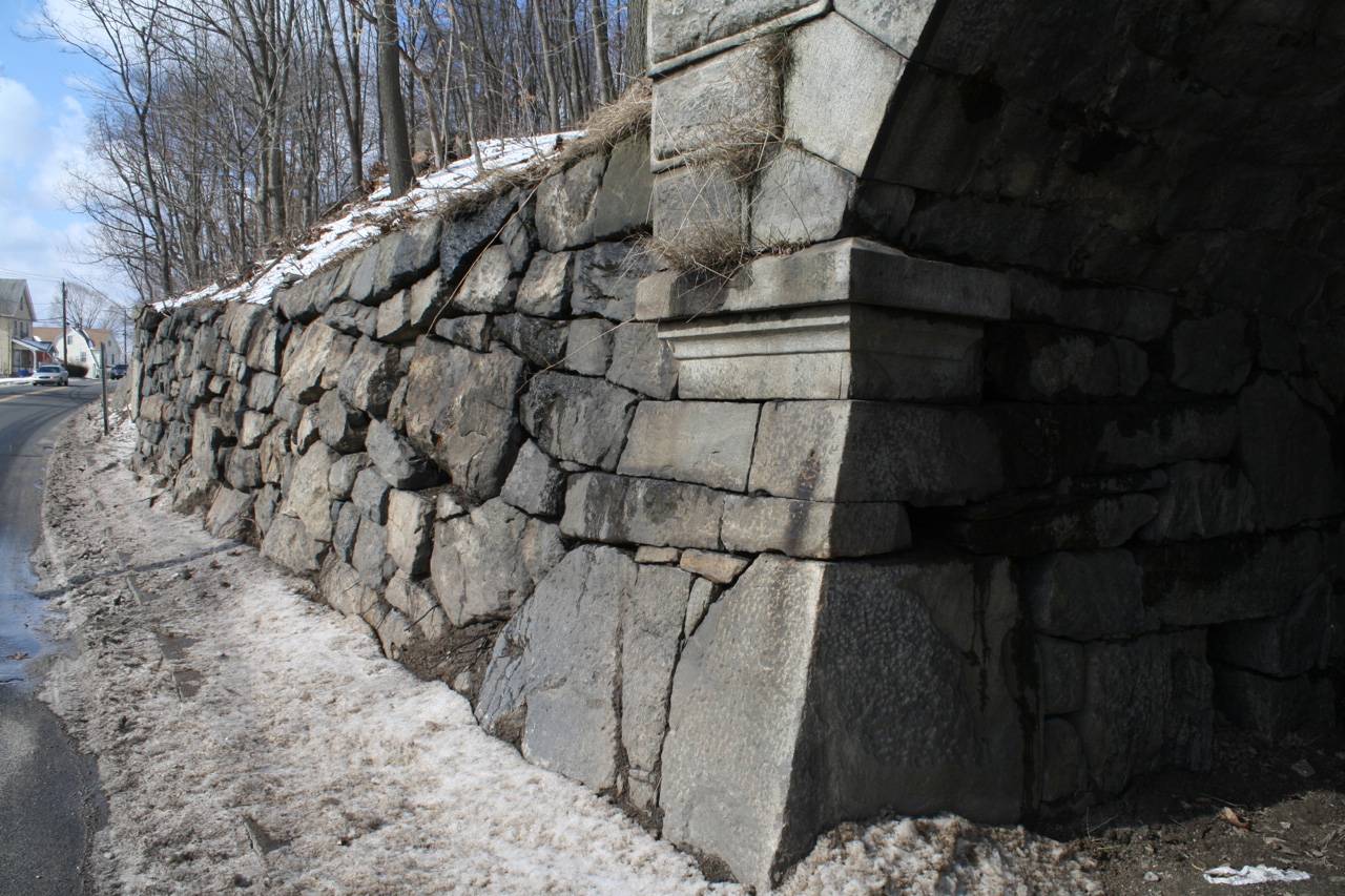
This is a barrel-vaulted masonry structure approximately 20’ wide, 20’ deep, and 14’ high. The vault is oriented east-west, banked into a hill which rises to the west. The east end is open to the street, abutting the sidewalk line of the modern roadway. The west end is formed of exposed natural rock, while the sides and roof are formed by a fieldstone masonry vault. The east façade surrounding the vault is formed of dressed ashlar masonry which blends into massive fieldstone retaining walls extending north and south along the sidewalk line. To the north the wall tapers down to grade while to the south the wall is approximately six feet high extending to meet the banked foundation wall to the south. Beyond this ruined foundation is a steep bedrock slope; historical photographs indicated that the retaining wall extended further south and that a series of terraces and ramps provided access to the hillside.
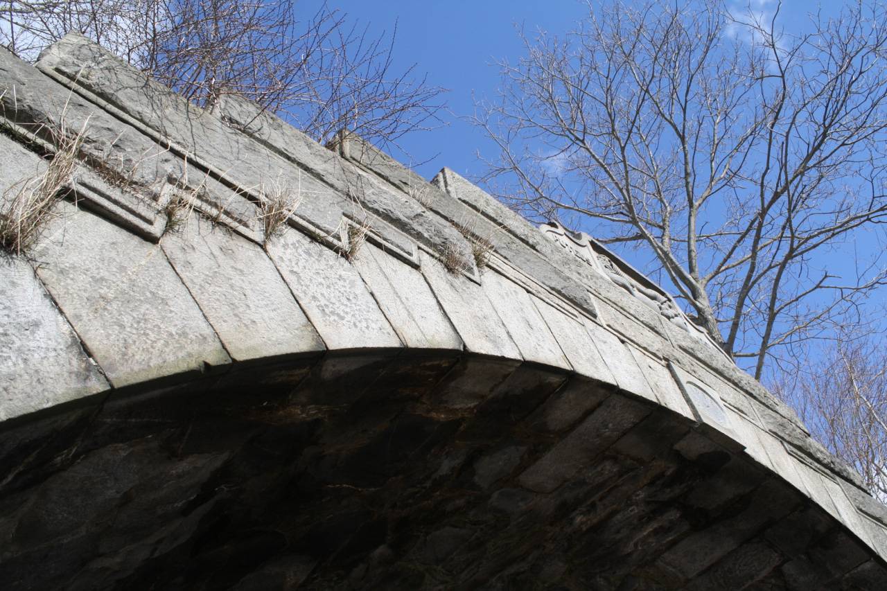
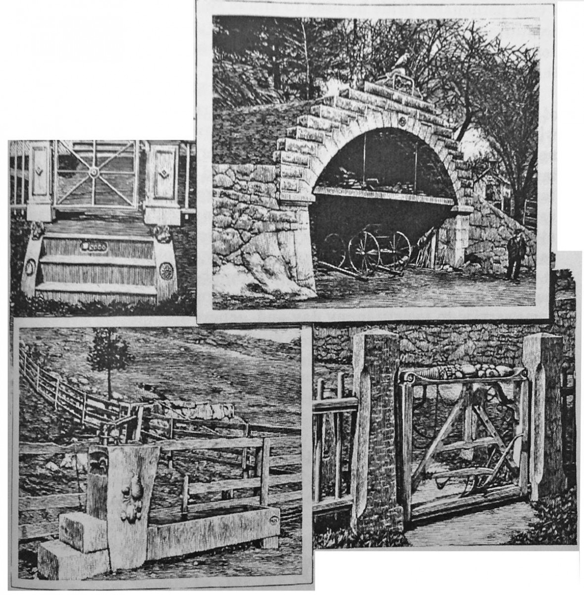
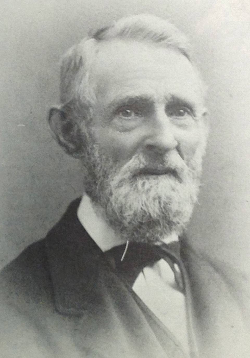
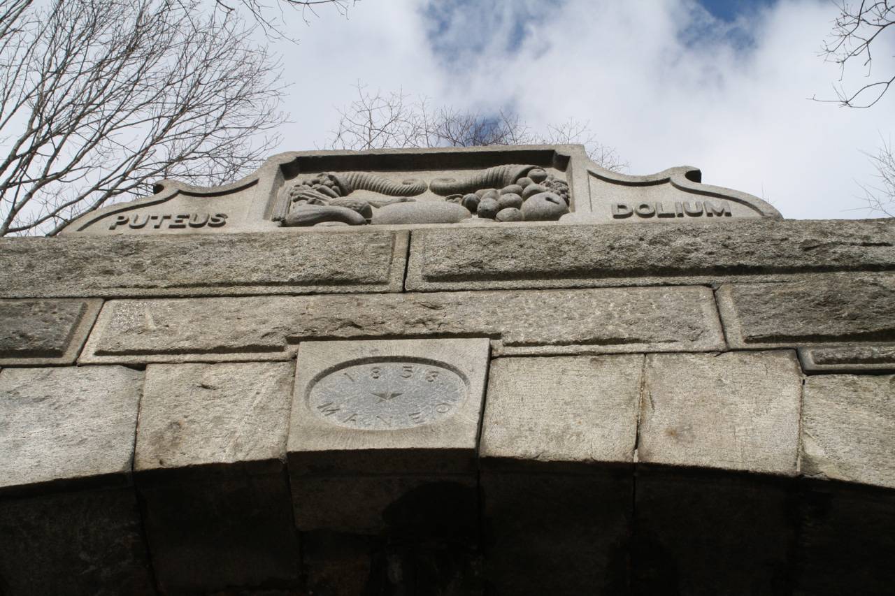
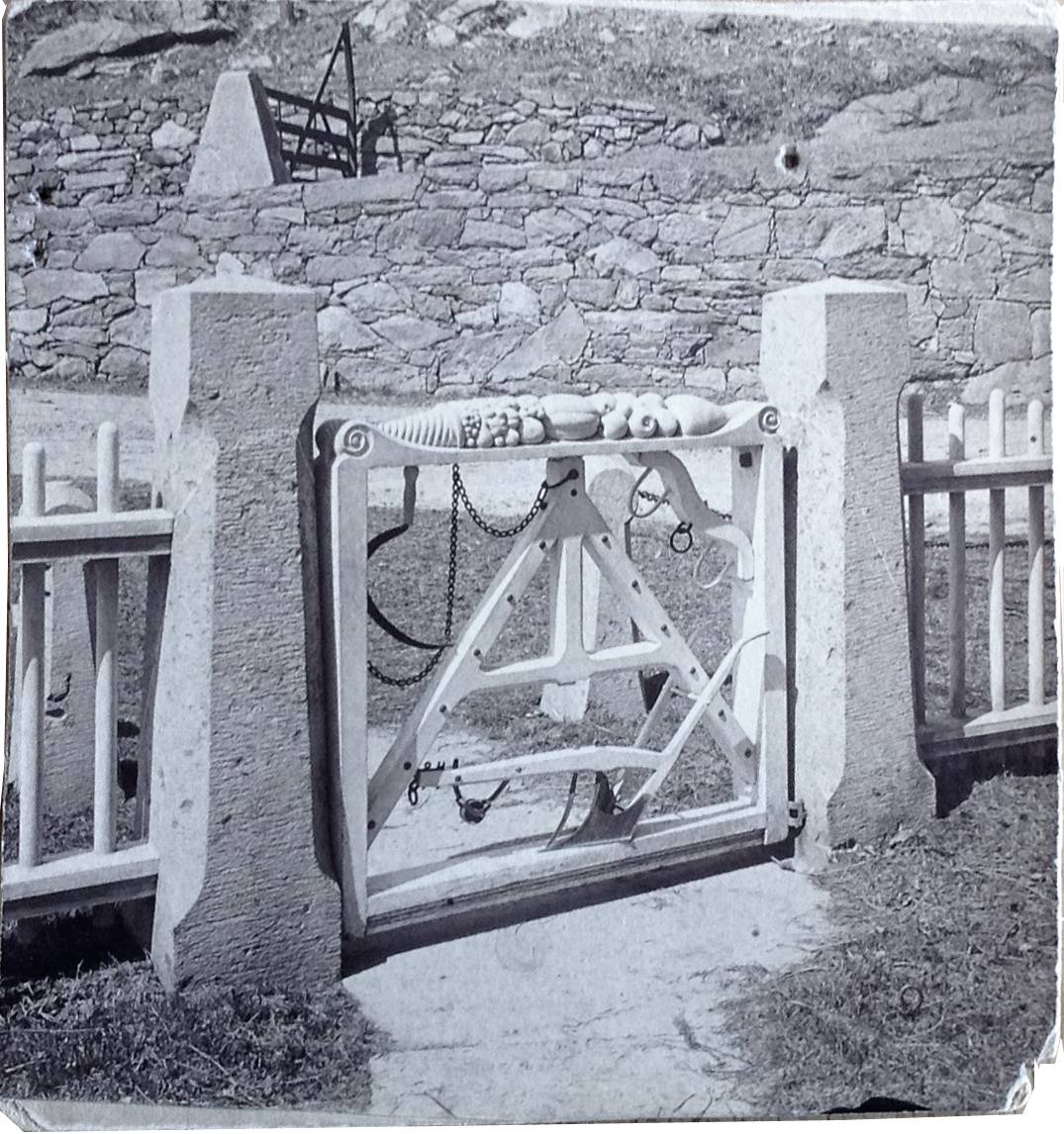
The east façade of the vaulted shed consists of wide corner piers approximately five feet high, slightly battered and topped by projecting water tables which form the spring lines for the arch. The arch is faced with dressed stone voussoirs with a textured surface. Surrounding the voussoirs is a course of rusticated blocks with exaggerated joints, stepping up to the top of the arch. The keystone is inscribed with the date 1858 and the Latin word “MANEO” (I endure) and an ornamental cap carved with a bas relief of horns of harvest fruits and vegetables. Originally a carved stone bird set atop the cap. Flanking the central panel are the words “PUTEUS” (well) and “DOLIUM” (cask or tun) forming a pun on the family name of the owner, Hobart Victory Welton.
The interior is a cave-like space lined with fieldstone masonry and with exposed bedrock at the back wall. The floor is earth. A historical image shows that there was a loft level platform, now gone, and that carriages were stored in the ground level area.
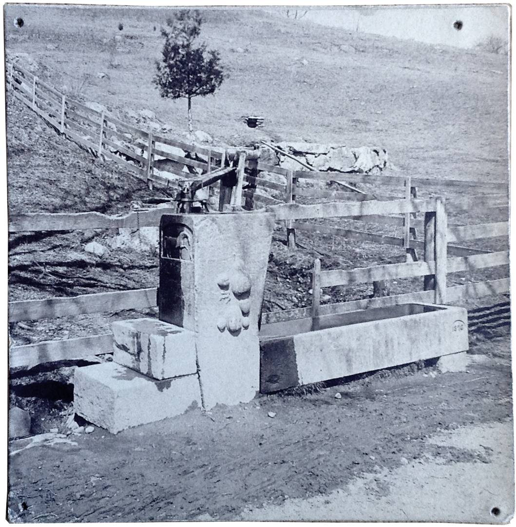
Historical significance:The Hobart V. Welton Carriage shed is an exceptional and unique structure in intact condition, significant because of the excellence of design and construction as a stone vault banked into the hill, with elegant classically-inspired details. It is unique as folk art, constructed to serve a simple farm function but created with extraordinary artistic and technical skill and with humor which is reflected both in the Latin pun incorporated into the stone decoration and the over-scaled stonework of the walls and vaulting. The juxtaposition of the stone vault and other embellishments to the site such as the gate and fountain, with the unpretentious Colonial-style house which was the Welton Farmstead, highlights his remarkable artistry in creating a sculptural environment for public enjoyment outside his front door. The Carriage shed derives additional significance from the association with the Welton family, descendants of one of the first proprietors of Mattatuck Plantation, and in particular as the most visible legacy of Hobart V. Welton, a prominent citizen, engineer, and artist.
Field Notes
Listed on the State Register of Historic Places 11/06/2013. Wolcott Street and Manor Avenue (Parcel ID: 0298-0098-0083) unusual banked carriage tunnel http://www.freewebs.com/waterbury-ct/outeast.htm
- Use & Accessibility
Use (Historic)
Use (Present)
Exterior Visible from Public Road?
Yes
Demolished
n/a
Location Integrity
Original Site
- Environment
Related features
Environment features
Relationship to surroundings
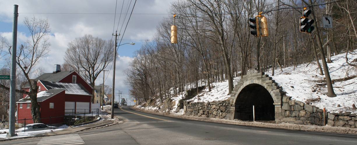
This unusual vaulted stone carriage shed is located on the west side of Wolcott Street, which curves around the toe of Long Hill on a route from the center of Waterbury toward the northeast to Wolcott. The stone vault of the shed has its open end abutting the sidewalk line and its interior banked into a steep hillside which rises toward the west. To the south there is an adjacent three-sided fieldstone foundation retaining wall indicating a former structure which was also banked into the hill. To the north a spring formerly had a piped outlet and functioned as a public fountain until the late 1950s.
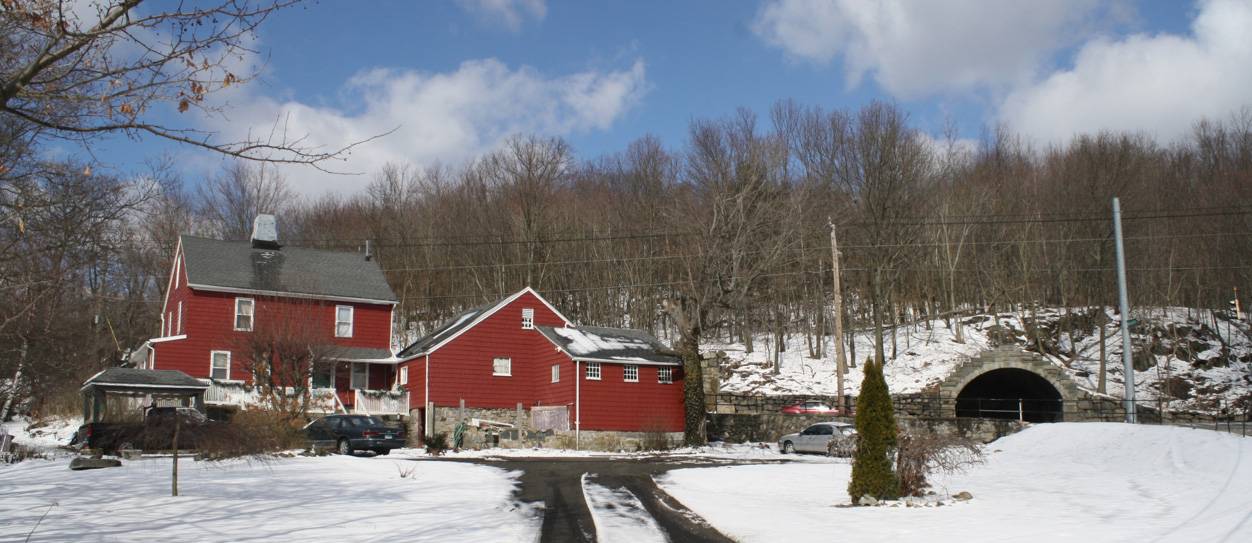
On the east side of the road across from the carriage shed is a c. 1819 Colonial-style house at 342 Wolcott Street, formerly associated with the carriage shed and other barns which are no longer extant. The house is sited at an oblique angle to the road, facing toward the west. The house is a 2 ½-story center-chimney gable-roofed house with its entry in the west-facing eave-façade. The west side is a four-bay façade in the manner of a half-house of the Colonial period; the entry door off-center toward the south, has a vernacular Federal-style surround with pilasters, lintel and four-light transom above the door. This is in the same bay as the center chimney. To the left are two bays with double-hung windows at the first and second floor levels, with simple trim including a shallow cornice. To the right of the door is a single window on each level. The house is 30’ x 30’ and has an attached garage and shed extending eastward. A shallow 1-story porch across the south gable-end has an open section and a small enclosed portion toward the east.. Siding is wood shingles and roof is asphalt shingles. The front yard elevation is below the sidewalk, indicating that in addition to being widened, the road has been raised up over the years.
Manor Avenue intersects Wolcott Street at the north border of the property. The carriage shed and its 2.7-acre site are owned by the State of Connecticut and the house at 342 Wolcott Street is privately-owned. However both were part of a single farmstead in the 19th century, along with a considerable acreage to the north and east. To the east is a densely built-up residential neighborhood of the mid-20th century, on land sloping down to the Mad River, which runs generally southward to meet the Naugatuck River. Several 19th-century factory sites along the river have been recently redeveloped as commercial shopping areas.
- Typology & Materials
-
Building Typology
Materials
Structural System
Roof materials
Roof type
Approximate Dimensions
14' x 20'
- Source
-
Date Compiled
03/18/2013
Compiled By
Charlotte Hitchcock, reviewed by CT Trust
Sources
Waterbury Time Machine web site:
http://www.freewebs.com/waterbury-ct/outeast.htm accessed 3/18/2013.Photographs and field notes by Charlotte Hitchcock 4/10/2013.
Interview with Mike Forina and Dr. Cynthia Roznoy of the Mattatuck Museum, 4/24/2013.Ancestry.com web site: http://records.ancestry.com/Hobart_Victory_Welton_records.ashx?pid=44127135
City of Waterbury Assessor’s Records http://www.equalitycama.com/tvweb/PropertyResults.aspx?city=Waterbury+2012+Revaluation
Parcel ID: 0298-0098-0083 .City of Waterbury
Map Viewer http://gis.waterburyct.org/GIS/Maps_Assessor.asp/City Landmarks: http://www.waterburyct.org/content/9586/10404/13826.aspx.
Aerial views from: http://maps.google.com/ and http://www.bing.com/maps/ accessed 4/10/2013.
Historical aerial photography accessed at UConn MAGIC: http://magic.lib.uconn.edu/mash_up/1934.html .
USGS Historical Maps at http://historical.mytopo.com/ accessed 4/10/2013.
UTM coordinates: http://itouchmap.com/latlong.html .
Anderson, Joseph, Ed., Prichard, Sarah J., The Town and City of Waterbury, Connecticut: from the aboriginal period to the year eighteen hundred and ninety-five, Price and Lee, New Haven, 1896.
Bronson, Henry, M.D., The History of Waterbury Connecticut, Bronson Brothers, Waterbury, 1858, accessed via Google Books, https://play.google.com/store/books/.
Connecticut Roads web site: http://www.kurumi.com/roads/ct/ct69.html .
Mattatuck Museum, Online collections datbase at http://www.mattatuckcollections.org/PRT0*9$116*98075 .
Museum archives including photographs, correspondence, and artifacts.Mattatuck Museum, Waterbury 1674-1974: a Pictorial History, Pequot Press, Chester, 1974.
Pape, William Jamison, Ed., History of Waterbury and the Naugtuck Valley, S.J. Clarke, New York, 1918, accessed via Google Books, https://play.google.com/store/books/.
Sexton, James, PhD; Survey Narrative of the Connecticut Barn, Connecticut Trust for Historic Preservation, Hamden, CT, 2005, http://www.connecticutbarns.org/history.
U.S. Federal Census, accessed at http://persi.heritagequestonline.com/hqoweb/library/do/census/search/basic
Visser, Thomas D., Field Guide to New England Barns & Farm Buildings, University Press of New England, 1997.
- PhotosClick on image to view full file
-